Rock
No
No
No
Fish and Aquatic Life
Overview
Rock River Water Quality Management Plan, Lower Rock River Appendix. WT-668-2002. South Central Region, WDNR.
Gibbs Lake is a small, hard water, drainage lake in Rock County, which drains through Gibbs Creek to the Yahara River. It has a surface area of 72 acres and a maximum depth of 20 feet. A popular county park surrounds two-thirds of the lake. A small dam was constructed in the 1960’s to control water levels and prevent the downstream movement of northern pike. The pike traveled downstream (instead of upstream) to spawn on a wetland area. The wetland often dried up and farmers would illegally harvest the fish with pitchforks. In the past, the lake was used by migrating and nesting waterfowl. The dam continues to hold the lake at a higher than normal level (about two feet) and prevents the unintentional downstream migration of northern pike.
Today, it has extensive vegetation with a large population of panfish. Extensive nutrient loads from non-point source pollution have caused occasional winterkill, nuisance aquatic growth and algae problems. Eurasian watermilfoil dominates the lake and water clarity is poor. The lake was the site of littoral zone research focusing on Eurasian watermilfoil. Secchi disk readings during 1986 indicated poor to very poor water clarity. Secchi disk readings from 1988 indicated good water clarity. One possible explanation for the differences between the readings is the lower rainfall, particularly in the spring of 1988, which may have reduced sediment and nutrients entering the lake. Agricultural runoff from the two-square-mile drainage area also affects the lake's water quality. Local interest in lake management and control of polluted runoff is high. Efforts to control soil erosion in this watershed should be made a priority. This lake would benefit from the identification of sources of polluted runoff and excess stormwater and the implementation of best management practices.
Controls have been imposed in an attempt to increase the fishery health of the lake. A weed-cutting project conducted by the University of Wisconsin served to cut predator lanes through the weedy patches. This increased panfish predation has helped to raise the overall size of bluegill by decreasing population pressure. This was effective only in the short term and was discontinued due to the high expense. A size limit for bass was also imposed, thereby increasing predators. In addition, walleye, northern pike and northern catfish have been stocked in this lake.
Agricultural runoff in this portion of the watershed affects the Gibbs Lake fishery. Siltation has caused loss of habitat and rough fish populations are a problem. Gibbs Lake is a panfish fishery and commonly found species include northern pike, common carp, golden shiner, white sucker, black bullhead, yellow bullhead, brown bullhead, green sunfish, pumpkinseed, bluegill, largemouth bass, yellow perch, walleye, black crappie. Access to the lake can be gained via Gibbs Lake Park.
Date 2002
Author Aquatic Biologist
Overview
The wetland area between Little Gibbs Lake and Gibbs Lake primarily shrub carr with some areas of wet meadows. The primary vegetation is cattails, reed canary grass and red-osier dogwood. The presence of reed canary grass is an indicator of disturbed wetland areas. Little detailed information is available on these wetlands. Gibbs Lake Park encompasses the wetlands between the lakes and around Gibbs Lake and improved information may interest the park’s visitors.
Date 2002
Author Aquatic Biologist
Historical Description
Source: 1970, Surface Water Resources of Rock County Gibbs Lake, T4N, R11E, Section 27
A hard water, drainage fed, natural lake connected to lake 34-5 (sometimes called Lower Gibbs Lake) by a small stream. The water level of Gibbs Lake is controlled by a low head dam at the outlet, which is the headwater of Gibbs Creek. The fish population was chemically eradicated in the summer of 1968 and the lake was restocked at a later time. Gibbs Lake should offer an excellent fishery in the near future. Shoreline development includes 1 boat rental and 11 dwellings. Unimproved public access is provided by a county park which includes two-thirds of the shoreline. The lake is commonly used by migrating and nesting waterfowl and there are no restrictions on hunting other than local ordinance.
Surface Acres = 72, S.D.F. = 1.10, Maximum Depth = 20 feet
Date 1970
Author Surface Water Inventory Of Wisconsin
Condition
Wisconsin has over 84,000 miles of streams, 15,000 lakes and milllions of acres of wetlands. Assessing the condition of this vast amount of water is challenging. The state's water monitoring program uses a media-based, cross-program approach to analyze water condition. An updated monitoring strategy (2015-2020) is now available. Compliance with Clean Water Act fishable, swimmable standards are located in the Executive Summary of Water Condition in 2018. See also the 'monitoring and projects' tab.
Reports
Management Goals
Wisconsin's Water Quality Standards provide qualitative and quantitative goals for waters that are protective of Fishable, Swimmable conditions [Learn more]. Waters that do not meet water quality standards are considered impaired and restoration actions are planned and carried out until the water is once again fishable and swimmable
Management goals can include creation or implementation of a Total Maximum Daily Load analysis, a Nine Key Element Plan, or other restoration work, education and outreach and more. If specific recommendations exist for this water, they will be displayed below online.
Monitoring
Monitoring the condition of a river, stream, or lake includes gathering physical, chemical, biological, and habitat data. Comprehensive studies often gather all these parameters in great detail, while lighter assessment events will involve sampling physical, chemical and biological data such as macroinvertebrates. Aquatic macroinvertebrates and fish communities integrate watershed or catchment condition, providing great insight into overall ecosystem health. Chemical and habitat parameters tell researchers more about human induced problems including contaminated runoff, point source dischargers, or habitat issues that foster or limit the potential of aquatic communities to thrive in a given area. Wisconsin's Water Monitoring Strategy was recenty updated.
Grants and Management Projects
| Project Name (Click for Details) | Year Started |
|---|
|
|
Monitoring Projects
| WBIC | Official Waterbody Name | Station ID | Station Name | Earliest Fieldwork Date | Latest Fieldwork Date | View Station | View Data |
|---|
| 799200 | Gibbs Lake | 10017708 | Gibbs Lake -- Access | 8/16/2011 | 8/16/2011 | Map | Data |
| 799200 | Gibbs Lake | 10045236 | Phragmites Occurrence - Gibbs Lake | | | Map | Data |
| 799200 | Gibbs Lake | 10007849 | Gibbs Lake | 8/28/1968 | 6/19/2023 | Map | Data |
| 799200 | Gibbs Lake | 10045237 | Phragmites Occurrence - Gibbs Lake | | | Map | Data |
| 799200 | Gibbs Lake | 10017707 | Gibbs Lake -- Access | 6/7/2005 | 6/22/2026 | Map | Data |
| 798800 | Gibbs Creek | 10045236 | Phragmites Occurrence - Gibbs Lake | | | Map | Data |
| 799200 | Gibbs Lake | 544001 | Gibbs Lake - Gibbs Lake | 8/30/1979 | 7/3/2018 | Map | Data |
| 798800 | Gibbs Creek | 10045237 | Phragmites Occurrence - Gibbs Lake | | | Map | Data |
| 799200 | Gibbs Lake | 543263 | Gibbs Lake - Deep Hole | 7/3/1986 | 7/18/2005 | Map | Data |
|
Watershed Characteristics
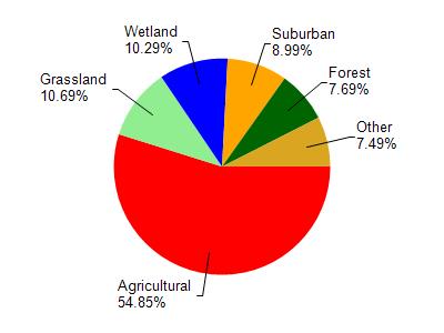
Gibbs Lake is located in the Yahara River and Lake Kegonsa watershed which is 126.33 mi². Land use in the watershed is primarily agricultural (54.90%), grassland (10.70%) and a mix of wetland (10.30%) and other uses (24.20%). This watershed has 145.73 stream miles, 3,600.04 lake acres and 6,832.19 wetland acres.
Nonpoint Source Characteristics
This watershed is ranked Medium for runoff impacts on streams, Low for runoff impacts on lakes and High for runoff impacts on groundwater and therefore has an overall rank of High. This value can be used in ranking the watershed or individual waterbodies for grant funding under state and county programs.This water is ranked High Lake for individual Lakes based on runoff problems and the likelihood of success from project implementation.