Dane
No
No
No
Fish and Aquatic Life
Overview
The Dunkirk Dam is located 2.9 miles downstream of the Stoughton Dam in Dunkirk. The first structure was authorized in 1843. In 1915, the Dunkirk Dam was destroyed by a washout caused by a large storm and was rebuilt the following year. In 1926, the City of Stoughton installed the necessary equipment to generate electrical power and generated power from 1926 to 1973. The dam was transferred from the City of Stoughton Electric Utility to the Wisconsin Edison Company in 1974. The Wisconsin Edison transferred the dam to the Dunkirk Dam Lake District in 1997, which currently owns the dam. The 20 foot dam holds a 13 foot hydraulic head and no longer produces power.
The DNR established the maximum level of the Dunkirk Pond at 832.30 feet and the minimum at 831.70 feet, MSL datum, in April 1985 with the idea of reducing the range of water level fluctuations in the pond and minimizing adverse impacts to wildlife, wetlands, and riparian landowners. The minimum flow passed through the dam is 25 cubic feet per second at all times.
Date 2002
Author Aquatic Biologist
Overview
Rock River Water Quality Management Plan, Lower Rock River Appendix. WT-668-2002. South Central Region, WDNR.
Dunkirk Dam is in need of major repair or removal. The DNR would like to remove the Dunkirk dam to improve fish and water quality on the Yahara. The effects of the removal are expected to be similar to improvements seen after the 1993 removal of Fulton Dam further downstream. Property owners around the impoundment formed the Dunkirk Dam Lake District to maintain the dam. The Dunkirk Dam Lake District recently turned down an offer by the DNR to buy their dam because the purchase would lead to the removal of the dam. Instead, the group of property owners voted 38-2 to go forward with reconstruction or replacement of the former hydropower dam. Repair costs are estimated at more than $300,000, half of which could come from a DNR grant if a fish passage was included in the construction. Removal costs would be considerably less often a third to a fifth of the repair costs.
The Lake District has partnered with Thomas Reiss of Dunkirk Water Power to begin generating power at the dam. An exemption has been approved by the Federal Energy Regulatory Commission. FERC is now the lead regulatory authority and is not requiring a fish passage to be constructed. The Lake District can cooperate with the department on the fish passage and receive the grant or can comply with FERC, not construct the passage but not receive the department cost sharing grant. The District has decided to not construct a fish passage.
An incident of an alleged failure to operate the dam occurred in March of 2000. The alleged violation caused the impoundment to fall below the established water levels on March 18 and 19, 2000. In addition, the alleged water level violation occurred at a very critical time in the fish spawning season likely harming reproduction. See Water Level Management for other possible impacts to the fishery. The Dunkirk Dam was opened to allow for repairs to be made in 2000. However, high water limited the amount of work that could be accomplished.
The Stebbinsville Dam is located approximately 4 miles downstream of Dunkirk in Rock County. The 19 foot high dam, with a 12 foot hydraulic head, is the most downstream dam on the Yahara River since the Fulton Dam was removed in 1993. The drainage area at the dam is about 430 sq. miles.
Built in 1917, the Stebbinsville Dam stopped generating power in 1996 and due to cracks in the left abutment wall and other structural problems, it has been drawn down since 1998. The dam owner, Wisconsin Edison Company, would need to repair the dam and apply for a FERC license or exemption before recommencing hydrogeneration.
The exposed lands behind the deteriorated dam have revegetated and some local residents are increasingly interested in having the dam removed. The Stebbinsville impoundment is highly silted and supports high densities of carp, which exacerbates turbidity and sedimentation problems in the river. Removal of the dam would open up an additional 4 miles of warm water fish habitat and could benefit over 50 species of fish found in the Yahara and Rock rivers. Repair or removal estimates have not been determined. However, according to a 1996 UW Extension report, dam repairs typically cost 3 to 5 times more than the one-time cost of dam removal. If it is repaired, provision must be made for an adequate fish passage around the dam.
Date 2002
Author Aquatic Biologist
Overview
Built in 1841, the Fulton dam was drawn down in 1986 and removed in 1993 due to its poor physical condition. The dam created a shallow, heavily silted, 49-acre pond and has functioned as a saw mill, grist mill, and has generated hydroelectric power. The drainage area of the former dam is 530 sq. miles.Carp dominated the pond s fishery prior to the drawdown and sport fish included black crappies, white bass, northern pike, bullheads and channel catfish. With the removal of the dam, walleye have begun moving upstream. Prior to drawdown about 40 acres of cattail-dominated wetland adjoined the impoundment. This wetland area is being replaced by fresh (wet) meadows dominated by grasses, such as red-top grass and reed canary grass, and by forbs such as goldenrod and aster. The former pond bed is covered by a colony of stinging nettle up to 8 feet high, which supports little wildlife. Down cutting of the old lakebed also occurred as the Yahara returned to its channel and reaches equilibrium.
Date 2002
Author Aquatic Biologist
Condition
Wisconsin has over 84,000 miles of streams, 15,000 lakes and milllions of acres of wetlands. Assessing the condition of this vast amount of water is challenging. The state's water monitoring program uses a media-based, cross-program approach to analyze water condition. An updated monitoring strategy (2015-2020) is now available. Compliance with Clean Water Act fishable, swimmable standards are located in the Executive Summary of Water Condition in 2018. See also the 'monitoring and projects' tab.
Recommendations
Lake Classification
Dane County Lake Classification-Phase 2: The Phase 1 classification grant classified all county lakes and streams. This grant will take the next step by developing a management program based on the classification.
Lake Classification
Dane County Department of Planning and Development will hire a project staff in order to develop a Lake Classification project, which is seen as the first step toward developing a consistent set of county-wide standards and procedures to protect Dane County Waters.
Management Goals
Wisconsin's Water Quality Standards provide qualitative and quantitative goals for waters that are protective of Fishable, Swimmable conditions [Learn more]. Waters that do not meet water quality standards are considered impaired and restoration actions are planned and carried out until the water is once again fishable and swimmable
Management goals can include creation or implementation of a Total Maximum Daily Load analysis, a Nine Key Element Plan, or other restoration work, education and outreach and more. If specific recommendations exist for this water, they will be displayed below online.
Monitoring
Monitoring the condition of a river, stream, or lake includes gathering physical, chemical, biological, and habitat data. Comprehensive studies often gather all these parameters in great detail, while lighter assessment events will involve sampling physical, chemical and biological data such as macroinvertebrates. Aquatic macroinvertebrates and fish communities integrate watershed or catchment condition, providing great insight into overall ecosystem health. Chemical and habitat parameters tell researchers more about human induced problems including contaminated runoff, point source dischargers, or habitat issues that foster or limit the potential of aquatic communities to thrive in a given area. Wisconsin's Water Monitoring Strategy was recenty updated.
Grants and Management Projects
Monitoring Projects
| WBIC | Official Waterbody Name | Station ID | Station Name | Earliest Fieldwork Date | Latest Fieldwork Date | View Station | View Data |
|---|
|
|
Watershed Characteristics
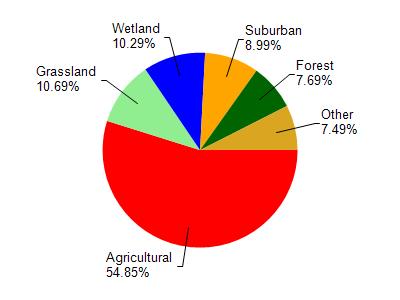
Unnamed is located in the Yahara River and Lake Kegonsa watershed which is 126.33 mi². Land use in the watershed is primarily agricultural (54.90%), grassland (10.70%) and a mix of wetland (10.30%) and other uses (24.20%). This watershed has 145.73 stream miles, 3,600.04 lake acres and 6,832.19 wetland acres.
Nonpoint Source Characteristics
This watershed is ranked Medium for runoff impacts on streams, Low for runoff impacts on lakes and High for runoff impacts on groundwater and therefore has an overall rank of High. This value can be used in ranking the watershed or individual waterbodies for grant funding under state and county programs.However, all waters are affected by diffuse pollutant sources regardless of initial water quality. Applications for specific runoff projects under state or county grant programs may be pursued. For more information, go to surface water program grants.