Dane
No
No
No
Fish and Aquatic Life
Overview
Rock River Water Quality Management Plan, Lower Rock River Appendix. WT-668-2002. South Central Region, WDNR.
Keenan Creek enters Lower Mud Lake on its southwestern shore. The creek drains approximately 3.6 square miles, which is largely agricultural in the northern portions and is adjoined by 400 acres of wetland in the southern reaches of the watershed. The creek is nearly 4.5 miles long and has a surface area of 2.1 acres. It has a gradient of 25 feet/mile and a baseflow of 1.3 cfs. The creek’s wetland area contains small springs and is valuable as waterfowl habitat. There are also wet meadows and shallow marshes further upstream. Small warm water forage fish are present, but the potential for the development of a more valuable fishery is low. The brook stickleback is the most commonly found fish species. A stream survey is needed to improve the level of data for Keenan Creek.
Date 2002
Author Aquatic Biologist
Historical Description
Keenan Creek -T6N, RI0E, Sec. 10, Surface acres = 2.1, Length = 4.4 miles, Stream order = I, Gradient = 25 ft/mile, Base discharge = 1.3 cfs.
Keenan Creek is a small tributary to the Yahara River system whIch flows through 400 acres of wetlands before entering Lower Mud Lake on its southwestern shore. This wetland area contains many small springs and is valuable as waterfowl habitat. There are also fresh meadows and shallow marshes further upstream. Small warm water forage fish are present, but the potential for the development of a more valuable fishery is low. Access is avaIlable at three road crossings and from the Yahara River system. Fish species: brook stickleback.
From: Day Elizabeth A.; Grzebieniak, Gayle P.; Osterby, Kurt M.; and Brynildson, Clifford L., 1985. Lake and Stream Classification Project. Surface Water Inventory of Dane County. Wisconsin Department of Natural Resources, Madison, WI
Date 1985
Author Surface Water Inventory Of Wisconsin
Impaired Waters
The 2018 assessments of Keenans Creek (WBIC 803500) showed impairment by phosphorus; new total phosphorus sample data overwhelmingly exceeded the 2018 WisCALM listing criteria for the Fish and Aquatic Life use. However, no biological data (i.e. no macroinvertebrate or fish Index of Biotic Integrity (IBI) scores) were available to assess biological impairment. Based on the most updated information, this water was proposed for the impaired waters list.
Date 2017
Author Ashley Beranek
Condition
Wisconsin has over 84,000 miles of streams, 15,000 lakes and milllions of acres of wetlands. Assessing the condition of this vast amount of water is challenging. The state's water monitoring program uses a media-based, cross-program approach to analyze water condition. An updated monitoring strategy (2015-2020) is now available. Compliance with Clean Water Act fishable, swimmable standards are located in the Executive Summary of Water Condition in 2018. See also the 'monitoring and projects' tab.
Reports
Management Goals
Wisconsin's Water Quality Standards provide qualitative and quantitative goals for waters that are protective of Fishable, Swimmable conditions [Learn more]. Waters that do not meet water quality standards are considered impaired and restoration actions are planned and carried out until the water is once again fishable and swimmable
Management goals can include creation or implementation of a Total Maximum Daily Load analysis, a Nine Key Element Plan, or other restoration work, education and outreach and more. If specific recommendations exist for this water, they will be displayed below online.
Monitoring
Monitoring the condition of a river, stream, or lake includes gathering physical, chemical, biological, and habitat data. Comprehensive studies often gather all these parameters in great detail, while lighter assessment events will involve sampling physical, chemical and biological data such as macroinvertebrates. Aquatic macroinvertebrates and fish communities integrate watershed or catchment condition, providing great insight into overall ecosystem health. Chemical and habitat parameters tell researchers more about human induced problems including contaminated runoff, point source dischargers, or habitat issues that foster or limit the potential of aquatic communities to thrive in a given area. Wisconsin's Water Monitoring Strategy was recenty updated.
Grants and Management Projects
| Project Name (Click for Details) | Year Started |
|---|
|
|
Monitoring Projects
| WBIC | Official Waterbody Name | Station ID | Station Name | Earliest Fieldwork Date | Latest Fieldwork Date | View Station | View Data |
|---|
|
|
Watershed Characteristics
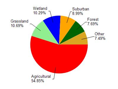
Keenans Creek is located in the Yahara River and Lake Kegonsa watershed which is 126.33 mi². Land use in the watershed is primarily agricultural (54.90%), grassland (10.70%) and a mix of wetland (10.30%) and other uses (24.20%). This watershed has 145.73 stream miles, 3,600.04 lake acres and 6,832.19 wetland acres.
Nonpoint Source Characteristics
This watershed is ranked Medium for runoff impacts on streams, Low for runoff impacts on lakes and High for runoff impacts on groundwater and therefore has an overall rank of High. This value can be used in ranking the watershed or individual waterbodies for grant funding under state and county programs.However, all waters are affected by diffuse pollutant sources regardless of initial water quality. Applications for specific runoff projects under state or county grant programs may be pursued. For more information, go to surface water program grants.