Dane
No
No
No
Fish and Aquatic Life
Overview
Lake Barney Wetlands Complex is a fresh meadow and marsh complex that stretches for a little more than one mile south of Dane County Highway M. Barney lake is a popular migratory waterfowl and songbird stopover, and at one time supported whistling swans which regularly used the west end of the complex. Polluted runoff, grazing and cultivation have; however, degraded water quality and habitat over the years. Swans no longer use the area due to polluted runoff and recent dry years. Projected development in the area remains the greatest threat to the wetlands. Still, Lake Barney remains a popular waterfowl area.
The U.S. Department of the Interior owns the wetlands complex west of Lake Barney. The complex has been identified as a Priority I wetland for management and protection by the Dane County Regional Planning Commission. Eighty acres immediately adjacent to Lake Barney are owned and managed by the Department of Corrections. Cattle and horses have grazed the wetland banks; fencing is needed to prevent the trampling and grazing of wetlands. Shoreline fencing to exclude grazing from all but a small portion of the wetlands' shoreline would allow regeneration of degraded areas and reduce erosion.
Date 2002
Author Aquatic Biologist
Historical Description
Source: 1985, Surface Water Resources of Dane County,WI: WI-DNR Barney Lake T6N, R9E, Sec. 34 Surface acres 27, SDF = 1.15, Maximum depth = 6 ft.
Barney Lake is a small, shallow, land-locked drift basin lake completely surrounded by land owned by the State Department of Health and Social Services. The watershed is largely agricultural though the shoreline is undeveloped and relatively undisturbed. A small fresh meadow adjoins the lake on the south end and provides some waterfowl habitat. Water quality is good, the bottom is sand and muck, and macrophytes are abundant. The lake has some aesthetic value but little recreational potential. This lake was once managed by the Department of Natural Resources as a warm water game fish rearing pond but is no longer used due to Its fluctuating water level. Winterkill conditions are severe though a few forage fish may survive. Public access is not available.
Date 1985
Author Surface Water Inventory Of Wisconsin
Condition
Wisconsin has over 84,000 miles of streams, 15,000 lakes and milllions of acres of wetlands. Assessing the condition of this vast amount of water is challenging. The state's water monitoring program uses a media-based, cross-program approach to analyze water condition. An updated monitoring strategy (2015-2020) is now available. Compliance with Clean Water Act fishable, swimmable standards are located in the Executive Summary of Water Condition in 2018. See also the 'monitoring and projects' tab.
Reports
Recommendations
Lake Classification
Dane County Lake Classification-Phase 2: The Phase 1 classification grant classified all county lakes and streams. This grant will take the next step by developing a management program based on the classification.
Lake Classification
Dane County Department of Planning and Development will hire a project staff in order to develop a Lake Classification project, which is seen as the first step toward developing a consistent set of county-wide standards and procedures to protect Dane County Waters.
Management Goals
Wisconsin's Water Quality Standards provide qualitative and quantitative goals for waters that are protective of Fishable, Swimmable conditions [Learn more]. Waters that do not meet water quality standards are considered impaired and restoration actions are planned and carried out until the water is once again fishable and swimmable
Management goals can include creation or implementation of a Total Maximum Daily Load analysis, a Nine Key Element Plan, or other restoration work, education and outreach and more. If specific recommendations exist for this water, they will be displayed below online.
Monitoring
Monitoring the condition of a river, stream, or lake includes gathering physical, chemical, biological, and habitat data. Comprehensive studies often gather all these parameters in great detail, while lighter assessment events will involve sampling physical, chemical and biological data such as macroinvertebrates. Aquatic macroinvertebrates and fish communities integrate watershed or catchment condition, providing great insight into overall ecosystem health. Chemical and habitat parameters tell researchers more about human induced problems including contaminated runoff, point source dischargers, or habitat issues that foster or limit the potential of aquatic communities to thrive in a given area. Wisconsin's Water Monitoring Strategy was recenty updated.
Grants and Management Projects
Monitoring Projects
| WBIC | Official Waterbody Name | Station ID | Station Name | Earliest Fieldwork Date | Latest Fieldwork Date | View Station | View Data |
|---|
| 777300 | Lake Barney | 10001226 | Lake Barney | 7/27/1999 | 9/22/2017 | Map | Data |
| 777300 | Lake Barney | 10060469 | TEST | | | Map | Data |
| 777300 | Lake Barney | 10037627 | Lake Barney | 8/9/2012 | 6/17/2025 | Map | Data |
| 777300 | Lake Barney | 10037696 | Lake Barney nearshore | 8/9/2012 | 8/9/2012 | Map | Data |
|
Watershed Characteristics
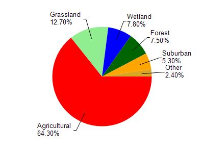
Lake Barney is located in the Badfish Creek watershed which is 84.21 mi². Land use in the watershed is primarily agricultural (64.30%), grassland (12.70%) and a mix of wetland (7.80%) and other uses (15.20%). This watershed has 78.94 stream miles, 217.98 lake acres and 3,799.54 wetland acres.
Nonpoint Source Characteristics
This watershed is ranked Medium for runoff impacts on streams, Not Ranked for runoff impacts on lakes and High for runoff impacts on groundwater and therefore has an overall rank of High. This value can be used in ranking the watershed or individual waterbodies for grant funding under state and county programs.However, all waters are affected by diffuse pollutant sources regardless of initial water quality. Applications for specific runoff projects under state or county grant programs may be pursued. For more information, go to surface water program grants.