")
9.02 Miles
0 - 9.02
Cool-Cold Mainstem, Cool-Warm Mainstem
2015
Good
Lincoln
No
No
No
Fish and Aquatic Life
Overview
Copper River - Creek 2-12, in the Copper River Watershed, is a 9.51 mile river that falls in Lincoln County. This river is managed for fishing and swimming and is currently not considered impaired.
Date 2011
Author Aquatic Biologist
Condition
Wisconsin has over 84,000 miles of streams, 15,000 lakes and milllions of acres of wetlands. Assessing the condition of this vast amount of water is challenging. The state's water monitoring program uses a media-based, cross-program approach to analyze water condition. An updated monitoring strategy (2015-2020) is now available. Compliance with Clean Water Act fishable, swimmable standards are located in the Executive Summary of Water Condition in 2018. See also the 'monitoring and projects' tab.
Reports
Management Goals
Wisconsin's Water Quality Standards provide qualitative and quantitative goals for waters that are protective of Fishable, Swimmable conditions [Learn more]. Waters that do not meet water quality standards are considered impaired and restoration actions are planned and carried out until the water is once again fishable and swimmable
Management goals can include creation or implementation of a Total Maximum Daily Load analysis, a Nine Key Element Plan, or other restoration work, education and outreach and more. If specific recommendations exist for this water, they will be displayed below online.
Monitoring
Monitoring the condition of a river, stream, or lake includes gathering physical, chemical, biological, and habitat data. Comprehensive studies often gather all these parameters in great detail, while lighter assessment events will involve sampling physical, chemical and biological data such as macroinvertebrates. Aquatic macroinvertebrates and fish communities integrate watershed or catchment condition, providing great insight into overall ecosystem health. Chemical and habitat parameters tell researchers more about human induced problems including contaminated runoff, point source dischargers, or habitat issues that foster or limit the potential of aquatic communities to thrive in a given area. Wisconsin's Water Monitoring Strategy was recenty updated.
Grants and Management Projects
| Project Name (Click for Details) | Year Started |
|---|
|
|
Monitoring Projects
| WBIC | Official Waterbody Name | Station ID | Station Name | Earliest Fieldwork Date | Latest Fieldwork Date | View Station | View Data |
|---|
| 1494700 | Copper River | 353369 | Alexander Flowage - 00 T31r6e S5 | | | Map | Data |
| 1494700 | Copper River | 10021832 | Copper River At Cth-E | 10/10/2007 | 1/1/2015 | Map | Data |
| 1494700 | Copper River | 353111 | Copper R at Cth M | 5/1/1979 | 1/1/2015 | Map | Data |
|
Watershed Characteristics
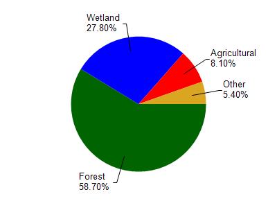
Copper River is located in the Copper River watershed which is 103.05 mi². Land use in the watershed is primarily forest (58.70%), wetland (27.80%) and a mix of agricultural (8.10%) and other uses (5.40%). This watershed has 187.03 stream miles, 64.93 lake acres and 15,346.42 wetland acres.
Nonpoint Source Characteristics
This watershed is ranked Not Ranked for runoff impacts on streams, Low for runoff impacts on lakes and Low for runoff impacts on groundwater and therefore has an overall rank of Low. This value can be used in ranking the watershed or individual waterbodies for grant funding under state and county programs.However, all waters are affected by diffuse pollutant sources regardless of initial water quality. Applications for specific runoff projects under state or county grant programs may be pursued. For more information, go to surface water program grants.
Copper River - Creek 2-12 is considered a Cool-Cold Mainstem, Cool-Warm Mainstem under the state's Natural Community Determinations.
Natural communities (stream and lake natural communities) represent model results and DNR staff valiation processes that confirm or update predicted conditions based on flow and temperature modeling from historic and current landscape features and related variables. Predicated flow and temperatures for waters are associated predicated fish assemblages (communities). Biologists evaluate the model results against current survey data to determine if the modeled results are corect and whether biological indicators show water quaity degradation. This analysis is a core component of the state's resource management framework. Wisconsin's Riverine Natural Communities.
Cool (Cold-Transition) Mainstem streams are moderate-to-large but still wadeable perennial streams with cold to cool summer temperatures. Coldwater fishes are common to uncommon, transitional fishes are abundant to common, and warm water fishes are uncommon to absent. Headwater species are common to absent,
mainstem species are abundant to common, and river species are common to absent.