Langlade
No
No
No
Fish and Aquatic Life
Overview
Antigo Lake is 32 acres in size and is comprised of a series of four interconnected basins. Maximum depth is 16 feet with an average depth is 7 feet. The drainage area of Antigo Lake is approximately 34.3 square miles. Spot checks of dissolved oxygen conditions in the lake during algal blooms show super saturated levels above 20 mg/L at the waters surface and under 3 mg/L only a few feet below the surface. These dissolved oxygen levels reveal that the summer algal blooms are having adverse chemical effects on the lake, which in turn effects the lake’s fish population.
Antigo Lake offers a diverse recreational resource, but has a history of water quality problems including algae blooms, and excess levels of sediment, nutrients and organic matter which limit its use.
Date 2002
Author Aquatic Biologist
Historical Description
Source: 1977, Surface Water Resources of Langlade County Kellog Pond T-31-N, R-11-E, Sec. 29, Surface Acres = 32.3, Maximum Depth = 7 feet, Secchi Disk = 4 feet.
A hard water drainage lake (impoundment) having slightly alkaline, clear water of low transparency. This impoundment is located on Spring Brook Creek within the city limits of Antigo. Its primary purpose is to control flood waters. A water control structure of approximately 3 head feet is present. The fish population within the impounded area is unknown, however, Spring Brook Creek above Kellog Pond is a classified trout stream. Public access is available at several road crossings. Of the 2.19 miles of shoreline, 0.65 mile is public.
Date 1977
Author Surface Water Inventory Of Wisconsin
Condition
Wisconsin has over 84,000 miles of streams, 15,000 lakes and milllions of acres of wetlands. Assessing the condition of this vast amount of water is challenging. The state's water monitoring program uses a media-based, cross-program approach to analyze water condition. An updated monitoring strategy (2015-2020) is now available. Compliance with Clean Water Act fishable, swimmable standards are located in the Executive Summary of Water Condition in 2018. See also the 'monitoring and projects' tab.
Reports
Recommendations
Shoreland Monitoring, Assessment, Inventory
Grant LPL-1363-10 - Shoreland Assessment, Inventory or Monitoring
Lake Management Plan Development
34945314
Lake Management Plan Development
34945317
Comprehensive Planning Studies
34945314
Comprehensive Planning Studies
34945317
Develop/Distribute Newsletter
Stormwater Planning, Implementation
Educate the public concerning the impacts of stormwater to Antigo Lake and Spring Brook.
Management Goals
Wisconsin's Water Quality Standards provide qualitative and quantitative goals for waters that are protective of Fishable, Swimmable conditions [Learn more]. Waters that do not meet water quality standards are considered impaired and restoration actions are planned and carried out until the water is once again fishable and swimmable
Management goals can include creation or implementation of a Total Maximum Daily Load analysis, a Nine Key Element Plan, or other restoration work, education and outreach and more. If specific recommendations exist for this water, they will be displayed below online.
Monitoring
Monitoring the condition of a river, stream, or lake includes gathering physical, chemical, biological, and habitat data. Comprehensive studies often gather all these parameters in great detail, while lighter assessment events will involve sampling physical, chemical and biological data such as macroinvertebrates. Aquatic macroinvertebrates and fish communities integrate watershed or catchment condition, providing great insight into overall ecosystem health. Chemical and habitat parameters tell researchers more about human induced problems including contaminated runoff, point source dischargers, or habitat issues that foster or limit the potential of aquatic communities to thrive in a given area. Wisconsin's Water Monitoring Strategy was recenty updated.
Grants and Management Projects
Monitoring Projects
| WBIC | Official Waterbody Name | Station ID | Station Name | Earliest Fieldwork Date | Latest Fieldwork Date | View Station | View Data |
|---|
| 1441100 | Antigo Lake (Kellog Pond) | 10042051 | Antigo Lake - EastBasin [Herbicide Monitoring Site 3] | 8/18/2009 | 10/20/2014 | Map | Data |
| 1441100 | Antigo Lake (Kellog Pond) | 10003215 | Antigo Lake | 7/27/1999 | 7/27/2017 | Map | Data |
| 1441100 | Antigo Lake (Kellog Pond) | 343073 | Kellog Pond - Deep Hole | 8/8/1985 | 8/23/2010 | Map | Data |
| 1441100 | Antigo Lake (Kellog Pond) | 10031332 | Antigo Lakes - Middle Basin (Basin 2) - Deepest Spot | 6/28/2010 | 4/9/2019 | Map | Data |
| 1441100 | Antigo Lake (Kellog Pond) | 10020136 | Antigo Lake -- Access | | | Map | Data |
| 1441100 | Antigo Lake (Kellog Pond) | 10021013 | Antigo Lake At Watson Road | 9/14/1989 | 9/14/1989 | Map | Data |
| 1441100 | Antigo Lake (Kellog Pond) | 10031333 | Antigo Lakes - Lower Basin (Basin 1) - Deepest Spot Near Dam | 6/28/2010 | 5/20/2026 | Map | Data |
| 1441100 | Antigo Lake (Kellog Pond) | 10022874 | Spring Brook Above Bridge At The End Of Virginia St. | 7/24/2012 | 7/24/2012 | Map | Data |
| 1441100 | Antigo Lake (Kellog Pond) | 10042050 | Antigo Lake - Mid Basin [Herbicide Monitoring Site 2] | 6/5/2014 | 7/2/2014 | Map | Data |
| 1440800 | Spring Brook | 10022874 | Spring Brook Above Bridge At The End Of Virginia St. | 7/24/2012 | 7/24/2012 | Map | Data |
| 1441100 | Antigo Lake (Kellog Pond) | 10042049 | Antigo Lake - West Basin [Herbicide Monitoring Site 1] | 6/5/2014 | 7/2/2014 | Map | Data |
|
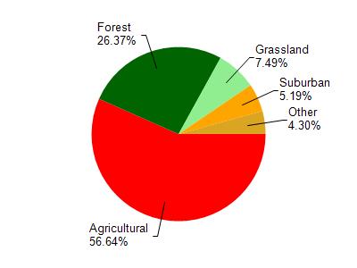
Watershed Characteristics
Antigo Lake (Kellog Pond) is located in the Springbrook Creek watershed which is 69.77 mi². Land use in the watershed is primarily agricultural (56.70%), forest (26.40%) and a mix of grassland (7.50%) and other uses (9.50%). This watershed has 99.73 stream miles, 65.96 lake acres and 977.95 wetland acres.
Nonpoint Source Characteristics
This watershed is ranked High for runoff impacts on streams, Medium for runoff impacts on lakes and High for runoff impacts on groundwater and therefore has an overall rank of High. This value can be used in ranking the watershed or individual waterbodies for grant funding under state and county programs.However, all waters are affected by diffuse pollutant sources regardless of initial water quality. Applications for specific runoff projects under state or county grant programs may be pursued. For more information, go to surface water program grants.