Iowa
No
No
Yes
Fish and Aquatic Life
Overview
Mill Creek is a tributary to the Wisconsin River at Tower Hill State Park. It is a Class II trout
stream for 4.5 miles of its length. One 4-mile section of trout water is downstream from Twin
Valley Lake, the other 0.5 mile stretch is downstream from the mouth of Trout Creek. Below
the last stretch of trout water, Mill Creek is considered a warm water sport fishery stream. A
rare aquatic species has been found in the creek in past surveys. The stream historically had
problems with flooding as a result of intensive agriculture and lumbering. Flood control
structures were put into place in the watershed to help lessen the problem. Two of these
structures formed Twin Valley and Cox Hollow Lakes in the upstream portion of Mill Creek.
These lakes are used primarily for fish, wildlife and recreational purposes. The creek below
the lakes and upstream from Trout Creek can have problems with cattle grazing and in-stream
sedimentation appears to be a problem.
From: Ripp, Coreen, Koperski, Cindy and Folstad, Jason. 2002. The State of the Lower Wisconsin River Basin.
PUBL WT-559-2002. Wisconsin Department of Natural Resources, Madison, WI.
Date 2002
Author Cynthia Koperski
Historical Description
Mill Creek is a tributary to the Wisconsin River at Tower Hill State Park. It is a Class II
trout stream for 4.5 miles of its length (WDNR, 1980). Below the last atretch of trout
water it is considered a warm water sport fishery stream (Schlesser, 1991-1992). In-
stream sedimentation appears to be a problem (WDNR, 1991). There are areas of
excessive cattle grazing in the upper reaches of the stream between Trout Creek and
Twin Hollow Lake (WDNR, 1991)
Date 1994
Author Surface Water Inventory Of Wisconsin
Historical Description
Mill Creek - Mouth location T8N R4E Section 20 -12, Gradient = 11.1 feet per mile, Total alkalinity = 240.0 mg/l, Volume of flow = 35.2 cfs.
The basic source of water of Mill Creek is springs on the Niagara escarpment of the Southwestern Uplands, but it also receives a considerable amount from runoff and ground seepage. Originally it began at springs in Cox Hollow (now Cox Hollow and Twin Valley Lakes) about 2.5 miles north of Dodgeville and flowed in a northeasterly direction to the Wisconsin River. The past history of this watershed shows that flooding was common and costly for farmers, the stream fishery, roads, and the soils of the basin. Pre-settlement times saw most of the watershed forested. The chief industry of early settlers, who moved into the area shortly after the Indian wars about the mid-nineteenth century, was lumbering.
Soon after, lumbering gave way to farming, first, in the form of wheat and then dairying. Cheese factories became common until modern transporation and refrigeration enabled milk to be safely transporated to distant markets. As of 1961 only one sawmill and four cheese factories remained. With the advent of intensive farming the choice land was cleared for crops and serious erosion followed. This was a common occurrence until recently when the Twin Parks Watershed plan was prepared by the Iowa Co. Soil Conservation District with the assistance of the USDA, USDI, and WDNR. The basic objectives of this plan included the installation of 10 floodwater structures and 4.5 miles of channel improvements. Eight of these are designed specifically for erosion control and three for fish and wildlife -Twin Valley, Birch, and Cox Hollow Lakes. Three others maintain a permanent pool deep enough to support a fishery but this is incidental to their primary purposes of flood control. Other works of improvement include land treatment measures such as contour farming and strip cropping, waterways, streambank protection and grade stabilization structures. The practices and structures completed to date have reduced severe flooding in this watershed. Some of the structures have reduced or eliminated the trout fishery in several tributary streams but the erosion control brought about by reduced flooding should enhance the fishery assets of the mainstream.
Principal tributaries include two of the best trout streams in the county in Love and Trout Creeks. Other streams of importance are Cutler, Ryan, and Hubbard Creeks. The total flow of these streams contributes about 56 percent of the base flow of Mill Creek. The most prized fishery in the watershed is for trout; however, the mainstream is managed for smallmouth bass and channel catfish. Other game fish species also present are largemouth bass, northern pike, rainbow trout and brown trout. Panfish include brown bullheads and bluegills. Forage and rough fish species include hornyhead
and creek chubs; redbelly and blacknose dace; stoneroller and fathead minnows; emeral shiners, carp, quillback carpsuckers, redhorse, white suckers, and sheepshead. There are at least 12 farm ponds in the watershed which support either largemouth bass-panfish or trout fisheries and are a major contributor to the overall fisheries resources of the area.
Aquatic game assets consist of ducks and beaver in lower sections and muskrats throughout its length.
Public access is available from Governor Dodge State Park but otherwise public lands are absent throughout the immediate drainage basin. Limited access is possible from 16 public road crossings.
From: Piening, Ronald and Threinen, C.W., 1968. Lake and Stream Classification Project. Surface Water Resources of Iowa County, Wisconsin Department of Natural Resources, Madison, WI.
Date 1968
Author Surface Water Inventory Of Wisconsin
Impaired Waters
Mill Creek (1242200) from its mouth to CTH H was placed on the impaired waters list for total phosphorus in 2012. The 2016 assessments showed continued impairment by phosphorus; total phosphorus sample data exceed 2016 WisCALM listing criteria for the Fish and Aquatic Life use, however, available biological data do not indicate impairment (i.e. no macroinvertebrate or fish Index of Biotic Integrity (IBI) scored in the "poor" condition category). This water was also assessed for temperature and sample data did not exceed 2016 WisCALM listing criteria for the Fish and Aquatic Life use. Based on the most updated information, no change in existing impaired waters listing is needed.
Date 2015
Author Aaron Larson
Condition
Wisconsin has over 84,000 miles of streams, 15,000 lakes and milllions of acres of wetlands. Assessing the condition of this vast amount of water is challenging. The state's water monitoring program uses a media-based, cross-program approach to analyze water condition. An updated monitoring strategy (2015-2020) is now available. Compliance with Clean Water Act fishable, swimmable standards are located in the Executive Summary of Water Condition in 2018. See also the 'monitoring and projects' tab.
Reports
Recommendations
Restore Wetlands
Restore Wetlands
Restore Wetlands
Restore Wetlands
Restore Wetlands
Restore Wetlands
Management Goals
Wisconsin's Water Quality Standards provide qualitative and quantitative goals for waters that are protective of Fishable, Swimmable conditions [Learn more]. Waters that do not meet water quality standards are considered impaired and restoration actions are planned and carried out until the water is once again fishable and swimmable
Management goals can include creation or implementation of a Total Maximum Daily Load analysis, a Nine Key Element Plan, or other restoration work, education and outreach and more. If specific recommendations exist for this water, they will be displayed below online.
Monitoring
Monitoring the condition of a river, stream, or lake includes gathering physical, chemical, biological, and habitat data. Comprehensive studies often gather all these parameters in great detail, while lighter assessment events will involve sampling physical, chemical and biological data such as macroinvertebrates. Aquatic macroinvertebrates and fish communities integrate watershed or catchment condition, providing great insight into overall ecosystem health. Chemical and habitat parameters tell researchers more about human induced problems including contaminated runoff, point source dischargers, or habitat issues that foster or limit the potential of aquatic communities to thrive in a given area. Wisconsin's Water Monitoring Strategy was recenty updated.
Grants and Management Projects
Monitoring Projects
| WBIC | Official Waterbody Name | Station ID | Station Name | Earliest Fieldwork Date | Latest Fieldwork Date | View Station | View Data |
|---|
| 1242200 | Mill Creek | 10017907 | Wisconsin River -- Tower Hill State Park Landing | 8/18/2009 | 6/12/2025 | Map | Data |
| 1242200 | Mill Creek | 10030075 | Mill Creek at CTH C | 6/2/2009 | 10/31/2023 | Map | Data |
| 1242200 | Mill Creek | 10048502 | Mill Creek at Amacher Hollow Road | 6/8/2018 | 10/31/2023 | Map | Data |
| 1242200 | Mill Creek | 10056287 | Mill Creek at CTH H | 5/13/2022 | 10/22/2024 | Map | Data |
|
Watershed Characteristics
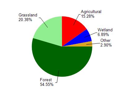
Mill Creek is located in the Mill and Blue Mounds Creek watershed which is 186.74 mi². Land use in the watershed is primarily forest (54.60%), grassland (20.40%) and a mix of agricultural (15.30%) and other uses (9.80%). This watershed has 382.87 stream miles, 106.91 lake acres and 6,596.99 wetland acres.
Nonpoint Source Characteristics
This watershed is ranked Medium for runoff impacts on streams, Low for runoff impacts on lakes and High for runoff impacts on groundwater and therefore has an overall rank of High. This value can be used in ranking the watershed or individual waterbodies for grant funding under state and county programs.However, all waters are affected by diffuse pollutant sources regardless of initial water quality. Applications for specific runoff projects under state or county grant programs may be pursued. For more information, go to surface water program grants.