Dane
No
Yes
No
Fish and Aquatic Life
Overview
Deer Creek rises on the southeast edge of Mount Horeb and flows southeast, joining with Fryes Feeder to become Mount Vernon Creek. Deer Creek is an exceptional resource water (ERW) and redside dace, a rare aquatic species, has been found in the creek. Deer Creek currently supports a Class II trout fishery as brook trout are readily abundant.
Water quality problems stemmed from runoff from barnyards and cultivated fields, excessive grazing, and increased residential development. Stream stabilization (fencing) projects have helped the stream’s trout fishery. In addition, Mt. Horeb, with assistance from the Dane County Land Conservation Department, developed a comprehensive stormwater management plan. Stream and habitat restoration projects have also recently (when?) been completed on the creek with funding from the state’s Targeted Runoff Management program. Re-write with Mike Sorge.1999 and 2000 baseline monitoring Re-write with Mike Sorge
Date 2002
Author Aquatic Biologist
Historical Description
Deer Creek -T6N, R7E Sec. 33, Surface acres = 4, Length = 5 miles, Stream order = I, Gradient = 42 ft/mile,
Base discharge = 1.7 cu. ft./sec.
This small stream joins Fryes Feeder to form Mount Vernon Creek. Its watershed is extensively pastured, stream bank cover is minimal, and summer water temperatures are quite high. Water quality is generally good, but turbidity and stream bank erosion are problems in pastured areas. The stream supports a good diversity of forage fish species, but has little potential to support a trout fishery. It has minimal value to wildlife or for recreational activities. Access is available at three road crossings and from Mount Vernon Creek. Fish species: stoneroller, redside and southern redbelly dace, creek chub, white sucker, brook stickleback, and mottled sculpln.
From: Day Elizabeth A.; Grzebieniak, Gayle P.; Osterby, Kurt M.; and Brynildson, Clifford L., 1985. Lake and Stream Classification Project. Surface Water Resources of Dane County, Wisconsin Department of Natural Resources, Madison, WI.
Date 1985
Author Surface Water Inventory Of Wisconsin
General Condition
Deer Creek (Mouth to first Highway 92 crossing below US 18-151) was assessed during the 2018 listing cycle; new biological (fish Index of Biotic Integrity (IBI) scores) and temperature sample data were clearly below the 2018 WisCALM listing thresholds for the Fish and Aquatic Life use. This water was meeting this designated use and was not considered impaired.
Date 2017
Author Ashley Beranek
Condition
Wisconsin has over 84,000 miles of streams, 15,000 lakes and milllions of acres of wetlands. Assessing the condition of this vast amount of water is challenging. The state's water monitoring program uses a media-based, cross-program approach to analyze water condition. An updated monitoring strategy (2015-2020) is now available. Compliance with Clean Water Act fishable, swimmable standards are located in the Executive Summary of Water Condition in 2018. See also the 'monitoring and projects' tab.
Reports
Recommendations
Citizen-Based Stream Monitoring
Collect chemical, physical, and/or biological water quality data to assess the current overall stream health. The data can inform management decisions and may be used to identify impaired waters for biennial lists.
Citizen-Based Stream Monitoring
Collect chemical, physical, and/or biological water quality data to assess the current overall stream health. The data can inform management decisions and may be used to identify impaired waters for biennial lists.
Management Goals
Wisconsin's Water Quality Standards provide qualitative and quantitative goals for waters that are protective of Fishable, Swimmable conditions [Learn more]. Waters that do not meet water quality standards are considered impaired and restoration actions are planned and carried out until the water is once again fishable and swimmable
Management goals can include creation or implementation of a Total Maximum Daily Load analysis, a Nine Key Element Plan, or other restoration work, education and outreach and more. If specific recommendations exist for this water, they will be displayed below online.
Monitoring
Monitoring the condition of a river, stream, or lake includes gathering physical, chemical, biological, and habitat data. Comprehensive studies often gather all these parameters in great detail, while lighter assessment events will involve sampling physical, chemical and biological data such as macroinvertebrates. Aquatic macroinvertebrates and fish communities integrate watershed or catchment condition, providing great insight into overall ecosystem health. Chemical and habitat parameters tell researchers more about human induced problems including contaminated runoff, point source dischargers, or habitat issues that foster or limit the potential of aquatic communities to thrive in a given area. Wisconsin's Water Monitoring Strategy was recenty updated.
Grants and Management Projects
Monitoring Projects
| WBIC | Official Waterbody Name | Station ID | Station Name | Earliest Fieldwork Date | Latest Fieldwork Date | View Station | View Data |
|---|
| 886900 | Deer Creek | 10054019 | Deer Cr @ HWY 92 3rd Upstream Crossing | | | Map | Data |
|
Watershed Characteristics
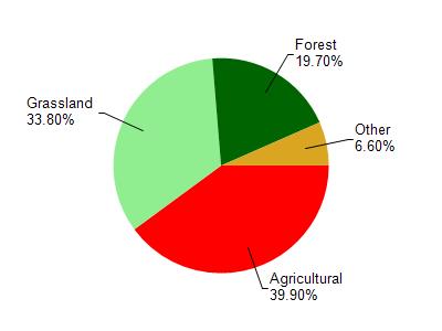
Deer Creek is located in the West Branch Sugar River - Mt. Vernon Cre watershed which is 66.74 mi². Land use in the watershed is primarily agricultural (39.90%), grassland (33.80%) and a mix of forest (19.70%) and other uses (6.60%). This watershed has 156.64 stream miles, 9.41 lake acres and 1,131.91 wetland acres.
Nonpoint Source Characteristics
This watershed is ranked High for runoff impacts on streams, Not Ranked for runoff impacts on lakes and High for runoff impacts on groundwater and therefore has an overall rank of High. This value can be used in ranking the watershed or individual waterbodies for grant funding under state and county programs.However, all waters are affected by diffuse pollutant sources regardless of initial water quality. Applications for specific runoff projects under state or county grant programs may be pursued. For more information, go to surface water program grants.