La Crosse
Yes
No
No
Fish and Aquatic Life
Historical Description
Mormon Coulee Creek is a backwater area of the Mississippi River. There is spring seepage and there is a continuous flow of water to the river from the pond. It has hard, alkaline, and clear water with a high transparency. Northern pike, perch, and bullhead dominate the fish species. The pond has a history of winterkill. There is access with parking. Beaver are present and muskrats are significant. Wood duck, mallard, and teal nesting takes place and migrant puddle ducks use the pond.
Source: 1976, Surface Water Resources of Buffalo County Lizzie Paul Pond, T21N, R12W, S29 Surface Acres = 44.0, S.D.F. = 1.08, Maximum depth = 4.0 feet.
Date 2002
Author Cynthia Koperski
General Condition
Mormon Coulee Creek (miles 0.84-17.67) was assessed during the 2018 listing cycle; new biological (fish Index of Biotic Integrity (IBI) scores) sample data were clearly below the 2018 WisCALM listing thresholds for the Fish and Aquatic Life use. This water was meeting this designated use and was not considered impaired.
Date 2017
Author Ashley Beranek
General Condition
The lower end of Mormon Coulee Creek is located on the south end of the City of La Crosse and the Town of Shelby. The stream has a fairly wide valley here surrounded by steep hills. The major land use was agriculture until fairly recently. Due to the close proximity to the City of La Crosse and beautiful landscape, numerous housing developments have been built in the lower end of the Mormon Coulee Creek watershed and more are planned. Trout streams in urban areas are rare due to the detrimental effects of stormwater runoff. Stormwater from areas with impervious surfaces such as roofs, sidewalks and streets generate more runoff of rainwater than vegetated areas. This added volume of runoff is often times warmer than the cold temperatures healthy trout streams require. When this warm water is discharged to trout streams and their tributaries, warming of the stream creates conditions which stress trout. The accumulation of these subdivisions eventually will produce stormwater volumes that exceed what agricultural lands previously generated. Additional volume of stormwater can reduce in-stream habitat through its scouring and erosive action. Infiltration of stormwater reduces surface water volume fluctuations in the stream during both dry and wet periods by returning the stormwater to groundwater, as was the case with natural vegetation or agricultural crops. Rain and snow that percolates through the ground, rather than over the land surface, is much cooler once it reaches the stream. All new subdivisions in the Mormon Coulee Creek watershed should detain and infiltrate their stormwater. To reduce the costs of stormwater systems and reduce the affects of stormwater to the stream, the City of La Crosse and the Town of Shelby should create a stormwater plan for the Mormon Coulee Creek watershed with costs shared by new subdivision developments.
Date 2011
Author Lisa Helmuth
Condition
Wisconsin has over 84,000 miles of streams, 15,000 lakes and milllions of acres of wetlands. Assessing the condition of this vast amount of water is challenging. The state's water monitoring program uses a media-based, cross-program approach to analyze water condition. An updated monitoring strategy (2015-2020) is now available. Compliance with Clean Water Act fishable, swimmable standards are located in the Executive Summary of Water Condition in 2018. See also the 'monitoring and projects' tab.
Reports
Recommendations
Restore Hydrology, Morphology
The Coulee Region Chapter of Trout Unlimited proposes to restore 1000 feet of streambank along Mormon Creek in the Town of Greenfield in La Crosse County. Major project elements to include: 1) reshaping and stabalization of streambanks, 2) dredging of silted-in pools, 3) placement of lunker structures.
Monitor Fish Community
The WDNR should survey Mormon Coulee Creek in the near future to determine if the introduction of wild brown trout develops into a self sustaining population.
Stormwater Planning, Implementation
The City of La Crosse and the Town of Shelby should create a stormwater plan for the Mormon Coulee Creek drainage area, with costs shared by new subdivision developments
Monitor Targeted Area
The La Crosse County Land Conservation Department should continue baseflow sampling of Mormon Coulee Creek to determine water quality trends.
Management Goals
Wisconsin's Water Quality Standards provide qualitative and quantitative goals for waters that are protective of Fishable, Swimmable conditions [Learn more]. Waters that do not meet water quality standards are considered impaired and restoration actions are planned and carried out until the water is once again fishable and swimmable
Management goals can include creation or implementation of a Total Maximum Daily Load analysis, a Nine Key Element Plan, or other restoration work, education and outreach and more. If specific recommendations exist for this water, they will be displayed below online.
Monitoring
Monitoring the condition of a river, stream, or lake includes gathering physical, chemical, biological, and habitat data. Comprehensive studies often gather all these parameters in great detail, while lighter assessment events will involve sampling physical, chemical and biological data such as macroinvertebrates. Aquatic macroinvertebrates and fish communities integrate watershed or catchment condition, providing great insight into overall ecosystem health. Chemical and habitat parameters tell researchers more about human induced problems including contaminated runoff, point source dischargers, or habitat issues that foster or limit the potential of aquatic communities to thrive in a given area. Wisconsin's Water Monitoring Strategy was recenty updated.
Grants and Management Projects
Monitoring Projects
| WBIC | Official Waterbody Name | Station ID | Station Name | Earliest Fieldwork Date | Latest Fieldwork Date | View Station | View Data |
|---|
| 1648300 | Mormon Creek | 10008619 | Mormon Coulee Creek #1 | 8/10/2011 | 9/13/2014 | Map | Data |
| 1648300 | Mormon Creek | 10008928 | Mormon Coulee Creek #6 - Bridge at Cth Yy | | | Map | Data |
| 1648300 | Mormon Creek | 10014117 | Mormon Coulee Creek Station 2 - Upper Half Of Rundahl Property | | | Map | Data |
| 1648300 | Mormon Creek | 10030753 | Mormon Creek in Mormon Coulee Park | 6/16/2003 | 1/1/2015 | Map | Data |
| 1648300 | Mormon Creek | 10008931 | Mormon Coulee Creek #10- Mouth Of Trib On Hartners Property | | | Map | Data |
| 1648300 | Mormon Creek | 10008660 | Mormon Coulee Creek #2 | | | Map | Data |
| 1648300 | Mormon Creek | 10008933 | Mormon Coulee Creek #8 - Hwy M Bridge | | | Map | Data |
| 1648300 | Mormon Creek | 10013524 | Mormon Coulee Creek St. 6 - 140 Meters Downstream Confluence Stream On Harter Property | 1/1/2015 | 1/1/2015 | Map | Data |
| 1648300 | Mormon Creek | 10020741 | Mormon Creek-North Off Hwy 14-61 | 9/13/2014 | 9/13/2014 | Map | Data |
| 1648300 | Mormon Creek | 10014114 | Mormon Coulee Creek Station 9 - 1000 Ft Below Kriebich Coulee Rd. Bridge Crossing | | | Map | Data |
| 1648300 | Mormon Creek | 10008923 | Mormon Coulee Creek #3 - Bridge Below Potato King | 1/1/2015 | 1/1/2015 | Map | Data |
| 1648300 | Mormon Creek | 10014110 | Mormon Coulee Creek Station 2 - Old Town Hall Rd. Bridge Crossing | | | Map | Data |
| 1648300 | Mormon Creek | 10008929 | Mormon Coulee Creek #7 - Schmitz Rd Bridge | | | Map | Data |
| 1648300 | Mormon Creek | 10008930 | Mormon Coulee Creek #9 - Kreibich Coulee Rd Bridge | 5/14/2009 | 6/30/2021 | Map | Data |
| 1648300 | Mormon Creek | 10044136 | Mormon Creek - Breidel Coulee Rd. Bridge | 7/23/2015 | 7/23/2015 | Map | Data |
| 1648300 | Mormon Creek | 10021340 | Mormon Coulee Creek - Cth Nn Bridge | 1/1/2015 | 1/1/2015 | Map | Data |
| 1648300 | Mormon Creek | 323003 | Mormon Creek - Bl Brookvw Trailer Stp | 5/23/2001 | 5/23/2001 | Map | Data |
| 1648300 | Mormon Creek | 10013523 | Mormon Coulee Creek St. 5 - Aprox. 200 Meters Upstream Nn Bridge | | | Map | Data |
| 1648300 | Mormon Creek | 10008927 | Mormon Coulee Creek #5 - Walking Bridge | 1/1/2015 | 1/1/2015 | Map | Data |
| 1648300 | Mormon Creek | 10013522 | Mormon Coulee Creek St. 4 - Farm Crossing At Roesler Farm | | | Map | Data |
| 1648300 | Mormon Creek | 323002 | Mormon Creek - Above Brookvw Trailer Stp | | | Map | Data |
| 1648300 | Mormon Creek | 323146 | Mormon Creek at Sth 35 | | | Map | Data |
| 1648300 | Mormon Creek | 10014111 | Mormon Coulee Creek Station 6 - 900 Feet Downstream Of Schmaltz Rd. | | | Map | Data |
| 1648300 | Mormon Creek | 10014112 | Mormon Coulee Creek Station 8 - 900 Ft Downstream Of Cth M Bridge Crossing | | | Map | Data |
| 1648300 | Mormon Creek | 10021338 | Mormon Coulee Creek Above Schmaltz Rd | 1/1/2015 | 1/1/2015 | Map | Data |
| 1648300 | Mormon Creek | 10013519 | Mormon Creek-150 Meters Below Cty Mm Bridge | 10/15/2004 | 10/13/2005 | Map | Data |
| 1648300 | Mormon Creek | 10033579 | Mormon Coulee Creek at machine crossing in T15NR6WS27SWNE | | | Map | Data |
| 1648300 | Mormon Creek | 323088 | Mormon Creek - Nw1/4 Of Sw1/4 Sec 26 | 4/29/1980 | 7/10/2006 | Map | Data |
| 1648300 | Mormon Creek | 10008917 | Mormon Coulee Creek #4 | | | Map | Data |
| 1648300 | Mormon Creek | 10014116 | Mormon Coulee Creek Station 1 - Lower End Of Rundahl Property Line | | | Map | Data |
| 1648300 | Mormon Creek | 323138 | Mormon Coulee Creek at CTH Nn Near St Joseph WI | 6/21/2001 | 10/17/2001 | Map | Data |
| 1648300 | Mormon Creek | 10013520 | Mormon Creek 3 - 50 Meters Downstream Walking Bridge In Mormon Coulee Park | 10/12/2004 | 10/13/2005 | Map | Data |
|
Volunteer Monitoring
Three Volunteer Stream Monitoring stations have been monitored by five volunteers from 2005 through 2010 in the Coon Creek Watershed. All stations are monitored using Water Action Volunteer (WAV) Level 1 procedures and are entered into the WAV database (http://www.uwex.edu/erc/wavdb/). On average, stations were monitored monthly from May through October with a total of seventeen fieldwork events entered for the watershed. All stations were monitored for biotic index, flow, dissolved oxygen, instantaneous temperature and transparency.
Volunteers collect macroinvertebrates twice a year to determine a biotic index for each stream monitored. Streams are considered in poor quality if biotic index is between 1.0-2.0, fair quality if between 2.1-2.5, and in good quality if the index is between 2.6-3.5. Generally, biotic index values rated streams in the watershed to be in poor quality (ranging from 1.3-1.8) in the spring and fair to good quality (ranging from 2.2-3.1) in the fall.
Stream flow varied between the three streams. Flow in Mormon Creek at Mormon Coulee Park Bridge, CBSM-10030753 and Mormon Creek, 1/2 mi. N. Kriebach Coulee Rd bridge, CBSM-10008930 averaged of 10-15 cubic feet per second (cfs), while Timber Coulee Creek near Moen Lane, CBSM-10032014 averaged 36 cfs. From 2005 through 2010, volunteers recorded dissolved oxygen levels in the watershed ranging from 7.4-12.4 mg/l, all of which are suffi cient to sustain aquatic life.
Temperature measurements, used to classify streams as cold, cool or warm water habitats, and which are indicative of the ability of a habitat to sustain aquatic species, were manually recorded at all three stations. Maximum instantaneous temperatures were below 25 C for all streams, suggesting they may be cold water streams.
Stream transparency measurements primarily indicated good water quality with 94% of measurements less than 10 NTU. Only one field event resulted in a measurement above this level. It was recorded on 7/27/2005 at Mormon Creek at Mormon Coulee Park Bridge, CBSM-10030753 with a measurement of 27 NTU.
Date 2011
Author Aquatic Biologist
Watershed Characteristics
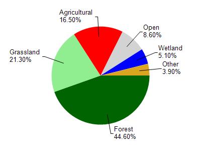
Mormon Creek is located in the Coon Creek watershed which is 238.20 mi². Land use in the watershed is primarily forest (44.60%), grassland (21.30%) and a mix of agricultural (16.50%) and other uses (17.60%). This watershed has 574.90 stream miles, 4,342.05 lake acres and 6,052.31 wetland acres.
Nonpoint Source Characteristics
This watershed is ranked High for runoff impacts on streams, Not Ranked for runoff impacts on lakes and Medium for runoff impacts on groundwater and therefore has an overall rank of Medium. This value can be used in ranking the watershed or individual waterbodies for grant funding under state and county programs.This water is ranked Medium Stream for individual Rivers based on runoff problems and the likelihood of success from project implementation.