Fond Du Lac
No
No
No
Fish and Aquatic Life
Overview
Mullet Creek State Wildlife Area, Fond du Lac County (WBICs 56000 and 5563544)
Around 1968, two dams were placed on Mullet Creek in Fond du Lac County west of CTH “G” to restore wetlands lost by drainage practices. Fish passage has not been addressed and so the dam presents a barrier to fish migration, most of the year. Fish passage occurs during high spring flows and heavy rainfall events via the emergency spillways and water control structures. Fish passage also occurs when full draw-downs are performed on the impoundments. No recent water quality data exist for this portion of the river.
Mullet Creek State Wildlife Area is a 2,217 acre property located in east-central Fond du Lac County. The wildlife area is located 15 miles east of Fond du Lac, and 10 miles west of Plymouth on Hwy 23. Travel south of Hwy. 23 on County Trunk G for one mile to the northeast corner of the wildlife area. This is where Mullet Creek flows under County Trunk G.
Mullet Creek State Wildlife Area consists of a rich array of wetland, forest, grassland and farmland. Mullet Creek flows through the entire property, eventually becoming the Mullet River and joining the Sheboygan River. The central portion of this property consists of shallow open water with submergent vegetation and cattail wetland totaling over 700 acres. Sedge, reed canary grass, willow, dogwood, swamp conifers and swamp hardwoods occur in the lowland areas. Oak, aspen and grass fields occur onthe upland sites.
Hybrid cattail, reed canary grass, garlic mustard, dame’s rocket, sptted knapweed, phragmites, and black locust present challenges to preserving the integrity of the natural communities found here.
Mullet Creek State Wildlife Area is located in the Middle to North Kettle Moraine Priority Conservation Opportunity Area - a terrestrial opportunity area of continental significance within the Southeast Glacial Plain Ecological Landscape.
T15N R19E Sec. 24, Surface Acres = 344, Maximum Depth = unknown
Date
Author Laurel Last
Condition
Wisconsin has over 84,000 miles of streams, 15,000 lakes and milllions of acres of wetlands. Assessing the condition of this vast amount of water is challenging. The state's water monitoring program uses a media-based, cross-program approach to analyze water condition. An updated monitoring strategy (2015-2020) is now available. Compliance with Clean Water Act fishable, swimmable standards are located in the Executive Summary of Water Condition in 2018. See also the 'monitoring and projects' tab.
Reports
Recommendations
Restore Wetlands
Restore Wetlands
Monitor Targeted Area
Increase invasive species monitoring and control at the Mullet Creek State Wildlife Area.
Fish Management, Access
Consider methods to improve fish passage at Mullet Creek State Wildlife Area, and if deemed desirable, secure funding for fish passage restoration
Master Planning
Ensure that issues and recommendations from the 2010 Mullet River Watershed Plan are considered during master planning and annual property planning for the Mullet Creek State Wildlife Area.
Management Goals
Wisconsin's Water Quality Standards provide qualitative and quantitative goals for waters that are protective of Fishable, Swimmable conditions [Learn more]. Waters that do not meet water quality standards are considered impaired and restoration actions are planned and carried out until the water is once again fishable and swimmable
Management goals can include creation or implementation of a Total Maximum Daily Load analysis, a Nine Key Element Plan, or other restoration work, education and outreach and more. If specific recommendations exist for this water, they will be displayed below online.
Monitoring
Monitoring the condition of a river, stream, or lake includes gathering physical, chemical, biological, and habitat data. Comprehensive studies often gather all these parameters in great detail, while lighter assessment events will involve sampling physical, chemical and biological data such as macroinvertebrates. Aquatic macroinvertebrates and fish communities integrate watershed or catchment condition, providing great insight into overall ecosystem health. Chemical and habitat parameters tell researchers more about human induced problems including contaminated runoff, point source dischargers, or habitat issues that foster or limit the potential of aquatic communities to thrive in a given area. Wisconsin's Water Monitoring Strategy was recenty updated.
Grants and Management Projects
Monitoring Projects
| WBIC | Official Waterbody Name | Station ID | Station Name | Earliest Fieldwork Date | Latest Fieldwork Date | View Station | View Data |
|---|
| 56000 | Mullet Marsh 15 Reservoir | 10002484 | Mullet Marsh | 7/27/1999 | 9/22/2017 | Map | Data |
|
Watershed Characteristics
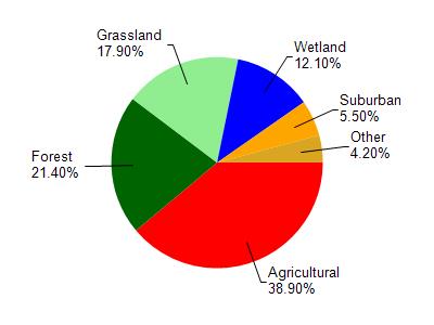
Mullet Marsh 15 Reservoir is located in the Mullet River watershed which is 88.19 mi². Land use in the watershed is primarily agricultural (38.90%), forest (21.40%) and a mix of grassland (17.90%) and other uses (21.80%). This watershed has 97.54 stream miles, 789.87 lake acres and 6,609.38 wetland acres.
Nonpoint Source Characteristics
This watershed is ranked High for runoff impacts on streams, Not Ranked for runoff impacts on lakes and High for runoff impacts on groundwater and therefore has an overall rank of High. This value can be used in ranking the watershed or individual waterbodies for grant funding under state and county programs.However, all waters are affected by diffuse pollutant sources regardless of initial water quality. Applications for specific runoff projects under state or county grant programs may be pursued. For more information, go to surface water program grants.