Price
No
No
No
Fish and Aquatic Life
Overview
Long Lake, in the Elk River Watershed, is a 419.40 acre impoundment that falls in Price County. This impoundment is managed for fishing and swimming and is currently considered impaired.
Date 2011
Author Aquatic Biologist
Historical Description
Source: 1983, Surface Water Resources of Price County Long Lake, T37N, RIE-RIW, Section 7, 12, 13
Long Lake is a soft water, drainage lake up on the Elk River with a 9-ft head dam (Jobes Dam) on its outlet. The purpose of the dam is level control and recreation. The upper end of the lake is within the city limits of Phillips and the lake has an outlet flow of 82.4 ft(3)sec. Besides the Elk River, the lake receives flow from Wilson Lake. These two lakes are separated by County Highway W. As its name implies, this lake is long and it also has a very irregular shape. There are 13 islands located within Long Lake. Its fish population consists of muskellunge, walleyes, largemouth bass, smallmouth bass, bluegills, black crappies, rock bass, pumpkinseeds, white suckers, redhorse, burbot and minnows. The lake is surrounded by upland and has steep bank on 70% of the shoreline. Its littoral bottom is made up of mainly sand and gravel with small areas of rubble and muck. Aquatic vegetation is scattered throughout the lake, with a few bays heavily weeded. The lake is used by nesting ducks, and other ducks and geese use the lake during their spring and fall migrations. Furbearer use is light and unimportant. Private development consists of 7 resorts and 126 cottages or homes on or near the lake. A small public access is provided off County Highway W. There is no other public frontage.
Surface Area = 418.3 acres, Maximum Depth = 54 ft, MPA = 30 ppm, Secchi disk = 4 ft
Date 1983
Author Surface Water Inventory Of Wisconsin
Condition
Wisconsin has over 84,000 miles of streams, 15,000 lakes and milllions of acres of wetlands. Assessing the condition of this vast amount of water is challenging. The state's water monitoring program uses a media-based, cross-program approach to analyze water condition. An updated monitoring strategy (2015-2020) is now available. Compliance with Clean Water Act fishable, swimmable standards are located in the Executive Summary of Water Condition in 2018. See also the 'monitoring and projects' tab.
Reports
Recommendations
Monitor Fish Tissue
Protect Riparian or Shorelands
Price County is sponsoring a project to restore 250 feet of shoreline habitat along the Elk River. There is an unstable 25 foot face that is actively eroding and needs to be stabilized. Fish- wildlife habitat and water quality will be improved. Project goals: 1) Reduce sediment and nutrient delivery; 2) Reduce instream sedimentation to improve fish spawning habitat; 3) Restore shore land habitat for wildlife; 4) Improve water quality; 5) Protect existing resources.
Management Goals
Wisconsin's Water Quality Standards provide qualitative and quantitative goals for waters that are protective of Fishable, Swimmable conditions [Learn more]. Waters that do not meet water quality standards are considered impaired and restoration actions are planned and carried out until the water is once again fishable and swimmable
Management goals can include creation or implementation of a Total Maximum Daily Load analysis, a Nine Key Element Plan, or other restoration work, education and outreach and more. If specific recommendations exist for this water, they will be displayed below online.
Monitoring
Monitoring the condition of a river, stream, or lake includes gathering physical, chemical, biological, and habitat data. Comprehensive studies often gather all these parameters in great detail, while lighter assessment events will involve sampling physical, chemical and biological data such as macroinvertebrates. Aquatic macroinvertebrates and fish communities integrate watershed or catchment condition, providing great insight into overall ecosystem health. Chemical and habitat parameters tell researchers more about human induced problems including contaminated runoff, point source dischargers, or habitat issues that foster or limit the potential of aquatic communities to thrive in a given area. Wisconsin's Water Monitoring Strategy was recenty updated.
Grants and Management Projects
Monitoring Projects
| WBIC | Official Waterbody Name | Station ID | Station Name | Earliest Fieldwork Date | Latest Fieldwork Date | View Station | View Data |
|---|
| 2239300 | Long Lake | 10005205 | Long Lake | 8/29/2000 | 10/17/2019 | Map | Data |
| 2236500 | Elk River | 513038 | Big Elk River - Sth 13 Phillips | 2/10/1975 | 9/16/2020 | Map | Data |
| 2239300 | Long Lake | 513094 | Long Lake - Deepest Spot (37 01e 12) | 6/19/1990 | 2/11/2020 | Map | Data |
| 2239300 | Long Lake | 513134 | Long Lake - North Central Basin (37 01w 12) | 5/1/2003 | 5/1/2003 | Map | Data |
|
Watershed Characteristics
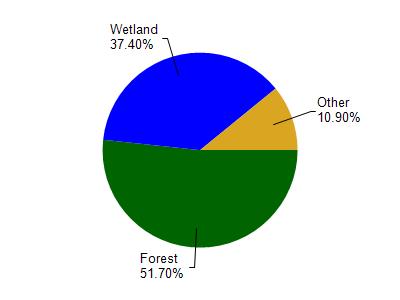
Long Lake is located in the Elk River watershed which is 261.12 mi². Land use in the watershed is primarily forest (51.70%), wetland (37.40%) and a mix of grassland (4.70%) and other uses (6.20%). This watershed has 254.00 stream miles, 2,883.84 lake acres and 49,382.72 wetland acres.
Nonpoint Source Characteristics
This watershed is ranked Not Ranked for runoff impacts on streams, Low for runoff impacts on lakes and Low for runoff impacts on groundwater and therefore has an overall rank of Low. This value can be used in ranking the watershed or individual waterbodies for grant funding under state and county programs.However, all waters are affected by diffuse pollutant sources regardless of initial water quality. Applications for specific runoff projects under state or county grant programs may be pursued. For more information, go to surface water program grants.