Vernon
Yes
Yes
No
Fish and Aquatic Life
Overview
Timber Coulee Creek, located in north central Vernon County, flows in a westerly direction for approximately 8.2 miles before reaching Coon Creek northeast of Coon Valley. This stream has a gradient of 40 feet per mile and drains steep forested hillsides and agricultural valley land. Timber Coulee Creek is a Class I trout stream for its entire length. Timber Coulee Creek is also an Outstanding Resource Water in Vernon County.
Date 2011
Author Cynthia Koperski
Historical Description
Timber Coulee Creek is a clear hard water tributary of Coon Creek flows in a westerly direction. It is managed as a brown trout stream, with a portion of it rated as Class II water and the remainder as Class III. A large variety of forage fish are present, as are brook lampreys. During the winter aerial groundwater survey, scattered open water areas were observed throughout the stream length. Though a rubble bottom type is dominant, there is considerable sand, and small amounts of silt, bedrock, gravel, boulder, and detritus. Access is provided from three road crossings, a county wayside, and from land under State control. There are about three acres of adjoining wetland. Muskrat are significant and beaver are present. Teal and wood duck broods are raised along the stream, and use is made of the water by migrant puddle ducks.
T14N, R5W, Section 4. Surface Acres = 13.9, Miles = 8.2, Gradient = 40.0 feet per mile.
From: Klick, Thomas A. and Threinen, C.W., 1973. Lake and Stream Classification Project. Surface Water Resources of Vernon County, Department of Natural Resources, Madison, WI.
Surveys of this stream first began in 1950. Trout were found but bank erosion was severe. In 1966, a P.L.566 flood detention project was installed in the watershed upstream of Timber Coulee Creek to alleviate flooding, but flash flooding still occurred, affecting the survival of trout in the stream. In 1955, the Wisconsin Conservation Department (now the WDNR) initiated a fishery habitat demonstration project along Bohemian Valley, Timber Coulee and Rullands Coulee Creeks. The purpose of this project was to develop and perfect in-stream habitat restoration techniques. This pioneering project resulted in restoration methods that are still used today in coulee region streams. Streambank erosion was reduced and fish cover increased by the installation of large rocks, root masses, log and rock deflectors.
The most recent stream survey, completed in 1999, found cold, clear water that carried a low suspended silt load. The streambed consisted of gravel, silt, rubble, and sand with lesser amounts of boulder, bedrock and detritus. Approximately 60% of in-stream fish cover consisted of LUNKER structures, while the remaining cover types were submergent vegetation, overhanging vegetation, boulders, woody debris, and natural undercut banks. A variety of aquatic insects have been documented through annual sampling. Six different forage fish species were collected in the 1999 survey as well as a fairly large mottled sculpin population, which are usually found only in very cold water. Both brook and brown trout were collected, however brown trout outnumber brook trout approximately 85:1. The brown trout population of Timber Coulee Creek was estimated at approximately 2000 fish per mile in 1999. Brown trout from Timber Coulee are collected on an as needed basis for brood stock to propagate wild brown trout for stocking statewide. These fish are then returned to the stream after the eggs and milt have been acquired.
Date 1973
Author Aquatic Biologist
General Condition
Timber Coulee Creek was assessed during the 2018 listing cycle; new biological (macroinvertebrate and fish Index of Biotic Integrity (IBI) scores) sample data were clearly below the 2018 WisCALM listing thresholds for the Fish and Aquatic Life use. This water was meeting this designated use and was not considered impaired.
Date 2017
Author Ashley Beranek
General Condition
The massive flooding that occurred in 2007 and 2008 in this watershed caused only minor damage to Timber Coulee Creek itself. The streambank and instream habitat work removed trees and reconnected the creek to its floodplain. These changes allowed the high water to come out of its normal banks without causing erosion. However, damage did occur at many road crossings where debris would pile up and block flood flows.
Macroinvertebrate surveys in the past few years ranged from fair to excellent quality. Excellent values were found at Coon Creek at HWY 61. Generally fair to good values were found at sites throughout the river system.
Date 2011
Author Lisa Helmuth
Condition
Wisconsin has over 84,000 miles of streams, 15,000 lakes and milllions of acres of wetlands. Assessing the condition of this vast amount of water is challenging. The state's water monitoring program uses a media-based, cross-program approach to analyze water condition. An updated monitoring strategy (2015-2020) is now available. Compliance with Clean Water Act fishable, swimmable standards are located in the Executive Summary of Water Condition in 2018. See also the 'monitoring and projects' tab.
Reports
Management Goals
Wisconsin's Water Quality Standards provide qualitative and quantitative goals for waters that are protective of Fishable, Swimmable conditions [Learn more]. Waters that do not meet water quality standards are considered impaired and restoration actions are planned and carried out until the water is once again fishable and swimmable
Management goals can include creation or implementation of a Total Maximum Daily Load analysis, a Nine Key Element Plan, or other restoration work, education and outreach and more. If specific recommendations exist for this water, they will be displayed below online.
Monitoring
Monitoring the condition of a river, stream, or lake includes gathering physical, chemical, biological, and habitat data. Comprehensive studies often gather all these parameters in great detail, while lighter assessment events will involve sampling physical, chemical and biological data such as macroinvertebrates. Aquatic macroinvertebrates and fish communities integrate watershed or catchment condition, providing great insight into overall ecosystem health. Chemical and habitat parameters tell researchers more about human induced problems including contaminated runoff, point source dischargers, or habitat issues that foster or limit the potential of aquatic communities to thrive in a given area. Wisconsin's Water Monitoring Strategy was recenty updated.
Grants and Management Projects
| Project Name (Click for Details) | Year Started |
|---|
|
|
Monitoring Projects
| WBIC | Official Waterbody Name | Station ID | Station Name | Earliest Fieldwork Date | Latest Fieldwork Date | View Station | View Data |
|---|
| 1646300 | Timber Coulee Creek | 10013680 | Timber Coulee Cr. St. 6 - 1981 Lower Line Fence | | | Map | Data |
| 1646300 | Timber Coulee Creek | 10022914 | Timber Coulee Cr Off Of Lars Hill Rd | 4/18/2007 | 1/1/2015 | Map | Data |
| 1646300 | Timber Coulee Creek | 10033504 | Timber Coulee Creek at Westby Rod and Gun Club | | | Map | Data |
| 1646300 | Timber Coulee Creek | 10013683 | Timber Coulee Cr. St. 5a - 1992 Lars Hill Rd. Upstream | | | Map | Data |
| 1646300 | Timber Coulee Creek | 10013679 | Timber Coulee Cr. St. 5 - 1981 1000 Ft. Downstream Of Lars Hill Rd. | | | Map | Data |
| 1646300 | Timber Coulee Creek | 10010628 | Timber Coulee Creek - 2 | | | Map | Data |
| 1646300 | Timber Coulee Creek | 10013682 | Timber Coulee Cr. St. 8 - 1984 1000 Ft. Downstream Of Junction Of Streams | | | Map | Data |
| 1646300 | Timber Coulee Creek | 10009099 | Timber Coulee Creek #6 Lower Fenceline Burke Property | 1/1/2015 | 1/1/2015 | Map | Data |
| 1646300 | Timber Coulee Creek | 10009100 | Timber Coulee Creek #7 Cth P Bridge At Golf Course | 1/1/2015 | 1/1/2015 | Map | Data |
| 1646300 | Timber Coulee Creek | 10015445 | Timber Coulee 2 | | | Map | Data |
|
Watershed Characteristics
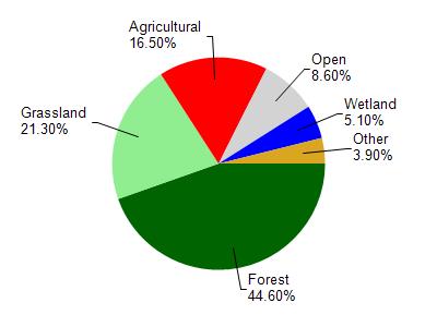
Timber Coulee Creek is located in the Coon Creek watershed which is 238.20 mi². Land use in the watershed is primarily forest (44.60%), grassland (21.30%) and a mix of agricultural (16.50%) and other uses (17.60%). This watershed has 574.90 stream miles, 4,342.05 lake acres and 6,052.31 wetland acres.
Nonpoint Source Characteristics
This watershed is ranked High for runoff impacts on streams, Not Ranked for runoff impacts on lakes and Medium for runoff impacts on groundwater and therefore has an overall rank of Medium. This value can be used in ranking the watershed or individual waterbodies for grant funding under state and county programs.This water is ranked Medium Stream for individual Rivers based on runoff problems and the likelihood of success from project implementation.