Green
No
Yes
No
Fish and Aquatic Life
Overview
The lower 4 miles of this 9 mile long stream are classified as a cold water fishery. The entire stream length is considered an ERW. About 3 miles of Liberty Creek are within the state wildlife area that bears its name. In this area, a high quality wetlands complex exists adjacent to the creek. Liberty Creek has not been monitored since 1983.
Date 2002
Author Aquatic Biologist
Overview
The lower 4 miles of this 9 mile long stream are classified as a cold water fishery. The entire stream length is considered an ERW. About 3 miles of Liberty Creek are within the state wildlife area that bears its name. In this area, a high quality wetlands complex exists adjacent to the creek. Liberty Creek has not been monitored since 1983.
Date 2000
Author Aquatic Biologist
Historical Description
Bush, D.M., R. Cornelius, D. Engle, and C.L. Brynildson. 1980. Lake and Stream Classification Project. Surface Water Resources of Green County, 2nd Edition. Wisconsin Department of Natural Resources, Madison, Wisconsin.
This rather sluggish trout stream flows southward and joins Allen Creek northeast of Albany. In the upper end
of the watershed the stream flows through a mixture of pasture, cropland and hardwood forest. The pastured areas suffer severe bank erosion, but in the cropland, a band of trees and shrubs stabilize the banks. The lower end of the stream flows through an open marsh with low stable banks. The water is generally clear, and one tributary (Cold Spring Creek) enters in Section ll.
Four miles of Liberty Creek upstream from the mouth are managed for trout, but the fishery is .maintained only
through the annual stocking of legal size trout. One mile below CTH "C"is considered as Class II with- the- remainder bein~ Class III. The stream's small flow and the shortage of pool areas limit its trout carrying
capacity. In addition, the bottom is flat and sandy with little instream cover or vegetation. A few smallmouth bass can be found in the lower end of the stream, and there is also a diverse population of forage fish which includes the rare least darter. Approximately 700 acres of wetland adjoin the creek, 505 acres of which are
part of the Liberty Creek Wildlife Area. Nesting and migratory waterfowl extensively use the area, and it is inhabited by a significant muskrat population. Public access is available from five road crossinqs, and the wildlife area provides 4.5 miles of public frontage on Liberty Creek. -
Fish Species: American brook lamprey, brown trout, central mudminnow, northern pike, central stoneroller, brassy minnow, spotfin shiner, bluntnose minnow, fathead minnow, creek chub, white sucker, northern hog sucker, brook stickleback, smallmouth bass, fantail darter, least darter, Johnny darter, blackside darter, mottled sculpin.
Surface Acres = 4.3, Length = 7.1 Miles, Gradient = 15 ft./mi., Base Discharge = 4.5 cu. ft./sec.
Date 1980
Author Surface Water Inventory Of Wisconsin
Historical Description
Flows south into Allen Creek. A small portion is managed for brown trout. Estimated 706 acres of hummocky bog and marshland lie adjacent to the stream. no bank cover is afforded as the stream is entirely in an open broad valley.From: Poff, Ronald J., and C.W. Threinen, Lake and Stream Classification Project. Surface Water Resources of Green County, Wisconsin Conservation Department, Madison I, 1961.Surface Acres= 4.3, Miles= 7.1, Gradient= 8.5' per mile
Date 1961
Author Surface Water Inventory Of Wisconsin
General Condition
Liberty Creek (CTH C to Elmer Rd) was assessed during the 2018 listing cycle; new biological (fish Index of Biotic Integrity (IBI) scores) sample data were clearly below the 2018 WisCALM listing thresholds for the Fish and Aquatic Life use. This water was meeting this designated use and was not considered impaired.
Date 2017
Author Ashley Beranek
Condition
Wisconsin has over 84,000 miles of streams, 15,000 lakes and milllions of acres of wetlands. Assessing the condition of this vast amount of water is challenging. The state's water monitoring program uses a media-based, cross-program approach to analyze water condition. An updated monitoring strategy (2015-2020) is now available. Compliance with Clean Water Act fishable, swimmable standards are located in the Executive Summary of Water Condition in 2018. See also the 'monitoring and projects' tab.
Reports
Recommendations
Citizen-Based Stream Monitoring
Collect chemical, physical, and/or biological water quality data to assess the current overall stream health. The data can inform management decisions and may be used to identify impaired waters for biennial lists.
Management Goals
Wisconsin's Water Quality Standards provide qualitative and quantitative goals for waters that are protective of Fishable, Swimmable conditions [Learn more]. Waters that do not meet water quality standards are considered impaired and restoration actions are planned and carried out until the water is once again fishable and swimmable
Management goals can include creation or implementation of a Total Maximum Daily Load analysis, a Nine Key Element Plan, or other restoration work, education and outreach and more. If specific recommendations exist for this water, they will be displayed below online.
Monitoring
Monitoring the condition of a river, stream, or lake includes gathering physical, chemical, biological, and habitat data. Comprehensive studies often gather all these parameters in great detail, while lighter assessment events will involve sampling physical, chemical and biological data such as macroinvertebrates. Aquatic macroinvertebrates and fish communities integrate watershed or catchment condition, providing great insight into overall ecosystem health. Chemical and habitat parameters tell researchers more about human induced problems including contaminated runoff, point source dischargers, or habitat issues that foster or limit the potential of aquatic communities to thrive in a given area. Wisconsin's Water Monitoring Strategy was recenty updated.
Grants and Management Projects
Monitoring Projects
| WBIC | Official Waterbody Name | Station ID | Station Name | Earliest Fieldwork Date | Latest Fieldwork Date | View Station | View Data |
|---|
|
|
Watershed Characteristics
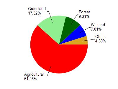
Liberty Creek is located in the Allen Creek and Middle Sugar River watershed which is 154.01 mi². Land use in the watershed is primarily agricultural (61.50%), grassland (17.30%) and a mix of forest (9.30%) and other uses (11.80%). This watershed has 263.25 stream miles, 96.10 lake acres and 5,963.23 wetland acres.
Nonpoint Source Characteristics
This watershed is ranked Medium for runoff impacts on streams, Not Ranked for runoff impacts on lakes and High for runoff impacts on groundwater and therefore has an overall rank of High. This value can be used in ranking the watershed or individual waterbodies for grant funding under state and county programs.This water is ranked High Stream for individual Rivers based on runoff problems and the likelihood of success from project implementation.