Barron
No
No
No
Fish and Aquatic Life
Overview
The Dallas Flowage is a 27-acre impoundment on Upper Pine Creek. A nine-foot water control
structure at the outlet is maintained by the village of Dallas. Excessive weeds and algae blooms have
been reported on ths lake in the past. A village park is on the flowage and a boat ramp is available
for public access. Current water quality information on this flowage would be useful. A self-help
volunteer could be instrumental in gaining this data.
Date 1996
Author Aquatic Biologist
Historical Description
Source: 1964, Surface Water Resources of Barron County Dallas Flowage T32N, R12W, Section 14
A hard water drainage impoundment on Upper Pine Creek. A nine-foot water control structure is maintained by the Village of Dallas on its outlet. Bullheads and forage minnows are the most common fish species. Weeds and excessive algae growth constitute a problem to management. A village park provides a picnicking area, public access and swimming facilities. Another public access near the dam also provides boat landing but has limited parking facilities. A few puddle and diving ducks use the flowage during migratory periods. Public frontage amounts to 0.2 miles of village-owned shoreline. Private development consists of six dwellings. The remaining lakeshore is under cultivation and pasture.
Surface Acres = 27.1, S.D.F. = 2.32, Maximum Depth = 9 feet
Date 1964
Author Surface Water Inventory Of Wisconsin
Condition
Wisconsin has over 84,000 miles of streams, 15,000 lakes and milllions of acres of wetlands. Assessing the condition of this vast amount of water is challenging. The state's water monitoring program uses a media-based, cross-program approach to analyze water condition. An updated monitoring strategy (2015-2020) is now available. Compliance with Clean Water Act fishable, swimmable standards are located in the Executive Summary of Water Condition in 2018. See also the 'monitoring and projects' tab.
Reports
Management Goals
Wisconsin's Water Quality Standards provide qualitative and quantitative goals for waters that are protective of Fishable, Swimmable conditions [Learn more]. Waters that do not meet water quality standards are considered impaired and restoration actions are planned and carried out until the water is once again fishable and swimmable
Management goals can include creation or implementation of a Total Maximum Daily Load analysis, a Nine Key Element Plan, or other restoration work, education and outreach and more. If specific recommendations exist for this water, they will be displayed below online.
Monitoring
Monitoring the condition of a river, stream, or lake includes gathering physical, chemical, biological, and habitat data. Comprehensive studies often gather all these parameters in great detail, while lighter assessment events will involve sampling physical, chemical and biological data such as macroinvertebrates. Aquatic macroinvertebrates and fish communities integrate watershed or catchment condition, providing great insight into overall ecosystem health. Chemical and habitat parameters tell researchers more about human induced problems including contaminated runoff, point source dischargers, or habitat issues that foster or limit the potential of aquatic communities to thrive in a given area. Wisconsin's Water Monitoring Strategy was recenty updated.
Grants and Management Projects
Monitoring Projects
| WBIC | Official Waterbody Name | Station ID | Station Name | Earliest Fieldwork Date | Latest Fieldwork Date | View Station | View Data |
|---|
| 2088000 | Dallas Flowage | 10000756 | Dallas Flowage | 8/7/2001 | 10/3/2016 | Map | Data |
| 2088000 | Dallas Flowage | 034002 | Dallas Lake - Dallas Lake | 8/31/1979 | 8/31/1979 | Map | Data |
| 2088000 | Dallas Flowage | 10018505 | Dallas Flowage/Upper Pine Creek -- Access | 7/24/2003 | 7/24/2003 | Map | Data |
|
Watershed Characteristics
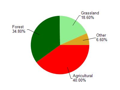
Dallas Flowage is located in the Pine Creek and Red Cedar River watershed which is 287.89 mi². Land use in the watershed is primarily agricultural (40%), forest (34.80%) and a mix of grassland (18.60%) and other uses (6.60%). This watershed has 538.68 stream miles, 84.94 lake acres and 12,197.18 wetland acres.
Nonpoint Source Characteristics
This watershed is ranked High for runoff impacts on streams, Low for runoff impacts on lakes and High for runoff impacts on groundwater and therefore has an overall rank of High. This value can be used in ranking the watershed or individual waterbodies for grant funding under state and county programs.However, all waters are affected by diffuse pollutant sources regardless of initial water quality. Applications for specific runoff projects under state or county grant programs may be pursued. For more information, go to surface water program grants.