Chippewa
No
No
No
Fish and Aquatic Life
Overview
Chapman Lake, an impoundment on the Wolf River in Stanley, had its dam renovated in 2009-2010 and is being dredged. In the summer of 2006 it experienced a signifi cant fish kill attributed to low oxygen. Flow into the lake
ceases during dry conditions. The lack of inflow, and naturally low oxygen levels of water entering the lake during dry periods, limits the lakes potential to maintain water quality and support fi sh. Like the river above the lake, the lake’s potential to maintain water quality and support fish is limited by natural conditions.
Date 2010
Author Mark Hazuga
Historical Description
A soft water, seepage impoundment on the Wolf River at Stanley, It has a 13-foot high water control structure on its outlet that is maintained by the city. It is a bass, pan fish lake and has the following species: northern pike, largemouth bass, bluegills, black crappies, rock bass, pumpkinseed, perch, bullheads, carp and white suckers. Its management problems include an occasional partial winterkill, excess weeds and slow growing pan fish. Muskrats and beaver are present. The lake area also offers nesting habitat for mallards. A 56-acre city park on the flowage provides facilities for swimming, camping and access. Its public frontage amounts to .90 miles of city owned shore line.
Surface Acres = 33.8, S.D.F. = 2.25, Maximum Depth = 13 feet
Source: 1963, Surface Water Resources of Chippewa County Chapman Lake T29N, R5W, Section 26
Date 1963
Author Surface Water Inventory Of Wisconsin
Condition
Wisconsin has over 84,000 miles of streams, 15,000 lakes and milllions of acres of wetlands. Assessing the condition of this vast amount of water is challenging. The state's water monitoring program uses a media-based, cross-program approach to analyze water condition. An updated monitoring strategy (2015-2020) is now available. Compliance with Clean Water Act fishable, swimmable standards are located in the Executive Summary of Water Condition in 2018. See also the 'monitoring and projects' tab.
Reports
Recommendations
Lake Management Plan Implementation
Chapman Lake habitat would benefi t from placement of woody structure in
the form of tree drops or cribs.
Engage Volunteers in Monitoring/Restoration
Volunteer monitoring lake water quality and invasive species should be established at Chapman Lake.(Type B).
Monitor Targeted Area
Conduct water quality monitoring of Chapman Lake (Type B).
Management Goals
Wisconsin's Water Quality Standards provide qualitative and quantitative goals for waters that are protective of Fishable, Swimmable conditions [Learn more]. Waters that do not meet water quality standards are considered impaired and restoration actions are planned and carried out until the water is once again fishable and swimmable
Management goals can include creation or implementation of a Total Maximum Daily Load analysis, a Nine Key Element Plan, or other restoration work, education and outreach and more. If specific recommendations exist for this water, they will be displayed below online.
Monitoring
Monitoring the condition of a river, stream, or lake includes gathering physical, chemical, biological, and habitat data. Comprehensive studies often gather all these parameters in great detail, while lighter assessment events will involve sampling physical, chemical and biological data such as macroinvertebrates. Aquatic macroinvertebrates and fish communities integrate watershed or catchment condition, providing great insight into overall ecosystem health. Chemical and habitat parameters tell researchers more about human induced problems including contaminated runoff, point source dischargers, or habitat issues that foster or limit the potential of aquatic communities to thrive in a given area. Wisconsin's Water Monitoring Strategy was recenty updated.
Grants and Management Projects
Monitoring Projects
| WBIC | Official Waterbody Name | Station ID | Station Name | Earliest Fieldwork Date | Latest Fieldwork Date | View Station | View Data |
|---|
| 2147200 | Chapman Lake | 094002 | Chapman Lake - Chapman Lake | 8/27/1979 | 8/27/1979 | Map | Data |
| 2147200 | Chapman Lake | 10055044 | Chapman Park | 5/24/2021 | 8/27/2025 | Map | Data |
| 2147200 | Chapman Lake | 999254 | Chapman Lake - Deep Hole | 7/29/1986 | 7/3/1987 | Map | Data |
| 2147200 | Chapman Lake | 10018402 | Chapman Lake -- Access | 9/16/2011 | 9/16/2011 | Map | Data |
| 2147200 | Chapman Lake | 10001048 | Chapman Lake | 8/29/2000 | 8/19/2017 | Map | Data |
|
Watershed Characteristics
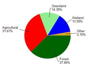
Chapman Lake is located in the North Fork Eau Claire River watershed which is 205.88 mi². Land use in the watershed is primarily forest (37.70%), agricultural (31.70%) and a mix of grassland (14.40%) and other uses (16.30%). This watershed has 411.76 stream miles, 302.30 lake acres and 18,394.61 wetland acres.
Nonpoint Source Characteristics
This watershed is ranked Low for runoff impacts on streams, Not Ranked for runoff impacts on lakes and High for runoff impacts on groundwater and therefore has an overall rank of High. This value can be used in ranking the watershed or individual waterbodies for grant funding under state and county programs.However, all waters are affected by diffuse pollutant sources regardless of initial water quality. Applications for specific runoff projects under state or county grant programs may be pursued. For more information, go to surface water program grants.