Douglas
No
No
No
Fish and Aquatic Life
Overview
Sauntrys Pocket, in the Upper St. Croix and Eau Claire Rivers Watershed, is a 103.38 acre lake that falls in Douglas County. This lake is managed for fishing and swimming and is currently not considered impaired.
Date 2011
Author Aquatic Biologist
Historical Description
Source: 1973, Surface Water Resources of Douglas County Sauntrys Pocket, T43N, R11W, Section 1, Surface Acres-109.8, Maximum Depth-9 feet, M.P.A.-18 ppm, Secchi Disk = Bottom A soft water seepage lake it is landlocked and surrounded by sandy upland except for a small shrub swamp off the south shore. The water is clear but shallow, and is subject to occasional winterkill conditions. An intermittent flowing outlet once drained north to the Eau Claire River, but for many years has been closed by an earthen dike. The resulting rise in lake level was only about a foot, and permanency in the water table is questionable. Littoral vegetation is moderate in abundance and consists of bulrushes and elodea, with yellow water lily and watershield also present. The bottom material along shore is mostly sand. Sauntrys Pocket has been managed for northern pike, largemouth bass, and panfish. A partial winterkill of record occurred in 1964-65. The present panfish population includes perch, pumpkinseed, bluegill, black crappies, and bullhead. Also present in the lake are white suckers, golden shiners, and creek chubs. With the absence of appreciable amounts of wetlands and aquatic vegetation, waterfowl and furbearer use is small, although a few mallards, teal, and loons nest here. The private development on shore includes one small resort and 13 cottages. The only public frontage on the lake is a Town of Wascott access on the southeast shore.
Date 1973
Author Surface Water Inventory Of Wisconsin
Condition
Wisconsin has over 84,000 miles of streams, 15,000 lakes and milllions of acres of wetlands. Assessing the condition of this vast amount of water is challenging. The state's water monitoring program uses a media-based, cross-program approach to analyze water condition. An updated monitoring strategy (2015-2020) is now available. Compliance with Clean Water Act fishable, swimmable standards are located in the Executive Summary of Water Condition in 2018. See also the 'monitoring and projects' tab.
Reports
Management Goals
Wisconsin's Water Quality Standards provide qualitative and quantitative goals for waters that are protective of Fishable, Swimmable conditions [Learn more]. Waters that do not meet water quality standards are considered impaired and restoration actions are planned and carried out until the water is once again fishable and swimmable
Management goals can include creation or implementation of a Total Maximum Daily Load analysis, a Nine Key Element Plan, or other restoration work, education and outreach and more. If specific recommendations exist for this water, they will be displayed below online.
Monitoring
Monitoring the condition of a river, stream, or lake includes gathering physical, chemical, biological, and habitat data. Comprehensive studies often gather all these parameters in great detail, while lighter assessment events will involve sampling physical, chemical and biological data such as macroinvertebrates. Aquatic macroinvertebrates and fish communities integrate watershed or catchment condition, providing great insight into overall ecosystem health. Chemical and habitat parameters tell researchers more about human induced problems including contaminated runoff, point source dischargers, or habitat issues that foster or limit the potential of aquatic communities to thrive in a given area. Wisconsin's Water Monitoring Strategy was recenty updated.
Grants and Management Projects
| Project Name (Click for Details) | Year Started |
|---|
|
|
Monitoring Projects
| WBIC | Official Waterbody Name | Station ID | Station Name | Earliest Fieldwork Date | Latest Fieldwork Date | View Station | View Data |
|---|
| 2495600 | Sauntrys Pocket Lake | 164011 | Sauntry'S Pocket Lake - Sauntry'S Pocket Lake | 7/12/1979 | 7/12/1979 | Map | Data |
| 2495600 | Sauntrys Pocket Lake | 10018766 | Sauntrys Pocket -- Access | 6/15/2012 | 8/10/2020 | Map | Data |
| 2495600 | Sauntrys Pocket Lake | 10002192 | Sauntrys Pocket Lake | 9/5/2000 | 8/19/2017 | Map | Data |
|
Watershed Characteristics
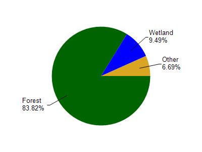
Sauntrys Pocket Lake is located in the Upper St. Croix and Eau Claire Rivers watershed which is 277.89 mi². Land use in the watershed is primarily forest (83.90%), wetland (9.50%) and a mix of open (4.30%) and other uses (2.40%). This watershed has 153.93 stream miles, 7,654.41 lake acres and 13,694.48 wetland acres.
Nonpoint Source Characteristics
This watershed is ranked Not Ranked for runoff impacts on streams, Not Ranked for runoff impacts on lakes and Low for runoff impacts on groundwater and therefore has an overall rank of Low. This value can be used in ranking the watershed or individual waterbodies for grant funding under state and county programs.However, all waters are affected by diffuse pollutant sources regardless of initial water quality. Applications for specific runoff projects under state or county grant programs may be pursued. For more information, go to surface water program grants.