")
34.30 Miles
0 - 34.30
Cool-Warm Mainstem, Cool-Warm Headwater
2025
Good
Douglas
No
No
No
Fish and Aquatic Life
Overview
The Middle River is a large stream originating in conifer swamps northeast of Bennett and emptying into Lake Superior between the Poplar and Amnicon rivers. The mouth of the Middle River forms an estuary at Lake Superior. The Lake Superior Binational Program identified the Middle River estuary as important to the integrity of the Lake Superior ecosystem for coastal wetlands and fish and wildlife spawning and nursery grounds. The shoreline in this area consists largely of eroding red clay deposits. The Middle River supports spawning brown and rainbow trout and flows through privately held lands. WDNR operates a permanent sea lamprey barrier immediately upstream of Highway 13.
There are no named tributaries to this river, and all the unnamed tributaries are considered forage fisheries. The Middle River was stocked with trout up until 1953, but stocking was discontinued due to poor survival rates. Surveys conducted in the 1970s indicate the river supports a resident forage fishery and undersized northern pike. Past water quality sampling indicates water quality standards were being met with the exception of high fecal coliform counts at State Highway 13. This could be the result of septic tank failure in the community of Wentworth. No recent data exists. The Middle River Health Care Center discharges treated effluent to this river. The facility was updated in 1981 and is in compliance with its discharge permit.
During survey work conducted as part of the coastal wetlands evaluation, no rare species of macroinvertebrate were found and the overall taxa richness was moderate (5-24 species) (Epstein 1997). The survey noted septic systems as potential pollutant sources.
From: Turville-Heitz, Meg. 1999. Lake Superior Basin Water Quality Management Plan. Wisconsin Department of Natural Resources, Madison, WI.
Date 1999
Author Aquatic Biologist
Condition
Wisconsin has over 84,000 miles of streams, 15,000 lakes and milllions of acres of wetlands. Assessing the condition of this vast amount of water is challenging. The state's water monitoring program uses a media-based, cross-program approach to analyze water condition. An updated monitoring strategy (2015-2020) is now available. Compliance with Clean Water Act fishable, swimmable standards are located in the Executive Summary of Water Condition in 2018. See also the 'monitoring and projects' tab.
Reports
Management Goals
Wisconsin's Water Quality Standards provide qualitative and quantitative goals for waters that are protective of Fishable, Swimmable conditions [Learn more]. Waters that do not meet water quality standards are considered impaired and restoration actions are planned and carried out until the water is once again fishable and swimmable
Management goals can include creation or implementation of a Total Maximum Daily Load analysis, a Nine Key Element Plan, or other restoration work, education and outreach and more. If specific recommendations exist for this water, they will be displayed below online.
Monitoring
Monitoring the condition of a river, stream, or lake includes gathering physical, chemical, biological, and habitat data. Comprehensive studies often gather all these parameters in great detail, while lighter assessment events will involve sampling physical, chemical and biological data such as macroinvertebrates. Aquatic macroinvertebrates and fish communities integrate watershed or catchment condition, providing great insight into overall ecosystem health. Chemical and habitat parameters tell researchers more about human induced problems including contaminated runoff, point source dischargers, or habitat issues that foster or limit the potential of aquatic communities to thrive in a given area. Wisconsin's Water Monitoring Strategy was recenty updated.
Grants and Management Projects
Monitoring Projects
| WBIC | Official Waterbody Name | Station ID | Station Name | Earliest Fieldwork Date | Latest Fieldwork Date | View Station | View Data |
|---|
| 2858800 | Middle River | 10040551 | Middle River at Sleepy Hollow Loop Rd | 6/16/2006 | 8/26/2021 | Map | Data |
| 2858800 | Middle River | 10051630 | Lackson Rd | | | Map | Data |
| 2858800 | Middle River | 10053745 | Middle River - East Moonshine Rd | 7/15/2024 | 4/8/2025 | Map | Data |
| 2858800 | Middle River | 10051628 | Upstream from Middle River Road | | | Map | Data |
| 2858800 | Middle River | 10032641 | Middle River at 1.4 miles E of Hines | | | Map | Data |
| 2858800 | Middle River | 163206 | Middle River - SeNe Sec 20 T47 R12w | 6/4/1979 | 10/7/1979 | Map | Data |
| 2858800 | Middle River | 10051631 | USH 2 | | | Map | Data |
| 2858800 | Middle River | 10013123 | Middle River- 15 Meters Upstream From Bridge On Townline Road-- Station #2 | 6/8/2017 | 10/31/2018 | Map | Data |
| 2858800 | Middle River | 163053 | Middle River at Sth 13 | 6/4/1979 | 10/7/1979 | Map | Data |
| 2858800 | Middle River | 10051626 | Cty B Downstream | | | Map | Data |
| 5501267 | Unnamed | 10051626 | Cty B Downstream | | | Map | Data |
| 2858800 | Middle River | 10039327 | Middle River at Middle River Rd | | | Map | Data |
| 2858800 | Middle River | 10013122 | Middle River- 400 Meters Downstream Hwy 13- Station #1 | | | Map | Data |
| 2858800 | Middle River | 10051629 | USH 53 | | | Map | Data |
| 2858800 | Middle River | 10053746 | Middle River - Wild Rivers Trail | | | Map | Data |
| 2858800 | Middle River | 10051627 | Old Hwy 11 | | | Map | Data |
| 2858800 | Middle River | 10050805 | Middle River Mouth Sandbar | 7/13/2012 | 7/13/2012 | Map | Data |
| 2858800 | Middle River | 163052 | Middle River at Cth B Bl Sanatorium | | | Map | Data |
|
Watershed Characteristics
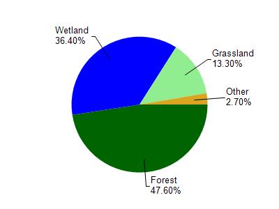
Middle River is located in the Amnicon and Middle Rivers watershed which is 288.92 mi². Land use in the watershed is primarily forest (47.60%), wetland (36.40%) and a mix of grassland (13.30%) and other uses (2.70%). This watershed has 641.39 stream miles, 7,914.74 lake acres and 42,306.80 wetland acres.
Nonpoint Source Characteristics
This watershed is ranked Not Ranked for runoff impacts on streams, Not Available for runoff impacts on lakes and Low for runoff impacts on groundwater and therefore has an overall rank of Low. This value can be used in ranking the watershed or individual waterbodies for grant funding under state and county programs.However, all waters are affected by diffuse pollutant sources regardless of initial water quality. Applications for specific runoff projects under state or county grant programs may be pursued. For more information, go to surface water program grants.
Middle River is considered a Cool-Warm Mainstem, Cool-Warm Headwater under the state's Natural Community Determinations.
Natural communities (stream and lake natural communities) represent model results and DNR staff valiation processes that confirm or update predicted conditions based on flow and temperature modeling from historic and current landscape features and related variables. Predicated flow and temperatures for waters are associated predicated fish assemblages (communities). Biologists evaluate the model results against current survey data to determine if the modeled results are corect and whether biological indicators show water quaity degradation. This analysis is a core component of the state's resource management framework. Wisconsin's Riverine Natural Communities.
Cool (Warm-Transition) Headwaters are small, sometimes intermittent streams with cool to warm summer temperatures. Coldwater fishes are uncommon to absent, transitional fishes are abundant to common, and warm water fishes are common to uncommon. Headwater species are abundant to common, mainstem species are common to absent, and river species are absent.