")
10.65 Miles
0 - 10.65
Macroinvertebrate, Cool-Cold Headwater, Coldwater, Cool-Warm Headwater
2010
Unknown
Ashland
No
No
No
Fish and Aquatic Life
Overview
This river and its two principal tributaries, Wood and Beartrap Creeks, feed the western part of the Kakagon/Bad River sloughs, emptying into Chequamegon Bay. The Kakagon River may once have been the channel of the White River, or even the Bad River, from earlier times. The Lake Superior fish contaminant monitoring strategy includes walleye sampling from this river to help monitor for trends in fish contamination, and for the purpose of protecting human health. This river is a short, drainage stream that flows from around Odanah north into Kakagon Slough. Fish species known to inhabit the stream include northern pike, walleye, smallmouth bass, panfish, suckers, redhorse and minnows. Beaver and muskrat are present in the area, along with waterfowl. See the discussion at the beginning of this watershed's narrative for more information on this stream.
During survey work conducted as part of the coastal wetlands evaluation, one rare species of macroinvertebrate were found and overall taxa richness was moderate (5-24 species) (Epstein 1997). Aquatic plants were significant at the survey site.
From: Turville-Heitz, Meg. 1999. Lake Superior Basin Water Quality Management Plan. Wisconsin Department of Natural Resources, Madison, WI.
Date 1999
Author Aquatic Biologist
Condition
Wisconsin has over 84,000 miles of streams, 15,000 lakes and milllions of acres of wetlands. Assessing the condition of this vast amount of water is challenging. The state's water monitoring program uses a media-based, cross-program approach to analyze water condition. An updated monitoring strategy (2015-2020) is now available. Compliance with Clean Water Act fishable, swimmable standards are located in the Executive Summary of Water Condition in 2018. See also the 'monitoring and projects' tab.
Reports
Recommendations
County Land and Water Management Plan
The Bayfield Regional Conservancy is sponsoring a project to develop a conservation plan (Plan) in Douglas County\2019s Lake Superior Watershed. The project will collect/review information about conservation values in the watershed; synthesize the info into the Plan; build a network with resource professionals and the local community; and prioritize priority conservation areas and strategies. Information, education, and outreach materials will be developed. The Plan will include GIS-based maps and information. An Executive Summary and outreach tool that explains conservation priority areas will accompany the Plan. The final deliverables include: the Plan, Executive Summary, and outreach tool and associated GIS maps, digital images and I & E materials.
Management Goals
Wisconsin's Water Quality Standards provide qualitative and quantitative goals for waters that are protective of Fishable, Swimmable conditions [Learn more]. Waters that do not meet water quality standards are considered impaired and restoration actions are planned and carried out until the water is once again fishable and swimmable
Management goals can include creation or implementation of a Total Maximum Daily Load analysis, a Nine Key Element Plan, or other restoration work, education and outreach and more. If specific recommendations exist for this water, they will be displayed below online.
Monitoring
Monitoring the condition of a river, stream, or lake includes gathering physical, chemical, biological, and habitat data. Comprehensive studies often gather all these parameters in great detail, while lighter assessment events will involve sampling physical, chemical and biological data such as macroinvertebrates. Aquatic macroinvertebrates and fish communities integrate watershed or catchment condition, providing great insight into overall ecosystem health. Chemical and habitat parameters tell researchers more about human induced problems including contaminated runoff, point source dischargers, or habitat issues that foster or limit the potential of aquatic communities to thrive in a given area. Wisconsin's Water Monitoring Strategy was recenty updated.
Grants and Management Projects
Monitoring Projects
| WBIC | Official Waterbody Name | Station ID | Station Name | Earliest Fieldwork Date | Latest Fieldwork Date | View Station | View Data |
|---|
| 2891600 | Unnamed | 10035559 | Unnamed Lake | 9/26/2010 | 9/26/2010 | Map | Data |
|
Watershed Characteristics
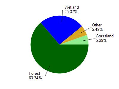
Kakagon River is located in the Lower Bad River watershed which is 123.92 mi². Land use in the watershed is primarily forest (63.80%), wetland (25.40%) and a mix of grassland (5.40%) and other uses (5.50%). This watershed has 317.28 stream miles, 11,923.85 lake acres and 17,289.12 wetland acres.
Nonpoint Source Characteristics
This watershed is ranked Not Ranked for runoff impacts on streams, Not Available for runoff impacts on lakes and Low for runoff impacts on groundwater and therefore has an overall rank of Low. This value can be used in ranking the watershed or individual waterbodies for grant funding under state and county programs.However, all waters are affected by diffuse pollutant sources regardless of initial water quality. Applications for specific runoff projects under state or county grant programs may be pursued. For more information, go to surface water program grants.
Kakagon River is considered a Macroinvertebrate, Cool-Cold Headwater, Coldwater, Cool-Warm Headwater under the state's Natural Community Determinations.
Natural communities (stream and lake natural communities) represent model results and DNR staff valiation processes that confirm or update predicted conditions based on flow and temperature modeling from historic and current landscape features and related variables. Predicated flow and temperatures for waters are associated predicated fish assemblages (communities). Biologists evaluate the model results against current survey data to determine if the modeled results are corect and whether biological indicators show water quaity degradation. This analysis is a core component of the state's resource management framework. Wisconsin's Riverine Natural Communities.
Cool (Warm-Transition) Headwaters are small, sometimes intermittent streams with cool to warm summer temperatures. Coldwater fishes are uncommon to absent, transitional fishes are abundant to common, and warm water fishes are common to uncommon. Headwater species are abundant to common, mainstem species are common to absent, and river species are absent.
Cool (Cold-Transition) Headwaters are small, usually perennial streams with cold to cool summer temperatures. Coldwater fishes are common to uncommon (<10 per 100 m), transitional fishes are abundant to common, and warm water fishes are uncommon to absent. Headwater species are abundant to common, mainstem species are common to absent, and river species are absent.