Ashland
No
No
No
Fish and Aquatic Life
Overview
This stream is primarily a warm water forage fishery, intermittent upstream of Highway 2. Northern pike and perch are present in perennial areas. The stream's outlet empties into an area of bogs and swamps that eventually seep into Honest John Lake and the Bad River Slough. The bog area is particularly susceptible to increased nutrient input (Spotts 1994, 1995). The slough area hosts beaver and waterfowl that nest in the willow and shrub swamp and fresh meadow wetlands. Denomie Creek passes through thick red clay deposits.
The Institute for Environmental Studies (IES) at the University of Wisconsin - Madison conducted its water resources practicum on the Bad River Reservation, focusing on the Denomie Creek Watershed. Sampling on Denomie Creek in the last 10 years was performed by the U.S. Geological Survey, Bad River Natural Resources Department (BRNRD) and the IES practicum. BRNRD sampling in 1993 found temperatures between 17 and 23.5 degrees Celsius and pH values between 7.14 and 6.57, which fell within the BRNRD's goals for surface waters. Low levels of dissolved oxygen, less than the recommended 5 parts per million needed to ensure active and healthy aquatic life, were found at two of the sampling locations. Department of Industry, Labor and Human Relations (DILHR) figures cited in the IES report indicate a significant increase in the number of septic systems in the area. Since the underlying red clay soils are impermeable and the permeable layers are close to the water table, continuing development of private septic systems could threaten groundwater quality.
A New Odanah wastewater treatment facility came on line in 1996, replacing the old lagoon system that had fallen into disrepair. The New Odanah facility discharges directly to Denomie Creek from a sequencing batch reactor, twice a day; the reach receiving the discharge has low flow or is stagnant most of the year, which reduces the stream's capacity to assimilate the effluent (BRNRD2). Plans exist to expand the sequencing batch reactor to allow more hookups in the near future (BRNRD2)
Aspen, which is harvested for pulp production, is the primary tree species in the watershed. Forestry is the principal land use and erosion is the principal problem in the forested portions of the watershed. The use of best-management practices for forestry could minimize the impact on surface waters.
From: Turville-Heitz, Meg. 1999. Lake Superior Basin Water Quality Management Plan. Wisconsin Department of Natural Resources, Madison, WI.
Date 1999
Author Aquatic Biologist
Overview
This watershed includes parts of the Bad River Slough, adjacent to where the Bad River enters Lake Superior. The IES students in their interviews with tribal elders were given the impression the quality of the wetlands may have declined, based on anecdotal evidence of decreased wild rice production.
The IES project interviewed members of the Bad River Band, with an emphasis on cultural needs the tribal lands serve; identified goals of establishing a water quality monitoring program, improving communication between Bad River Natural Resources Department and the public, evaluating tribal legal options such as zoning, developing a geographic information system (GIS) document and maps; and looked at the legal process for establishing water quality standards. Among general recommendations that resulted from the IES study, students proposed that land use analysis to protect water quality be done, especially for groundwater, and mapping be improved in the southern part of the reservation that serves as the recharge area for reservation drinking water wells, where groundwater is more susceptible to contamination. The IES plan makes the recommendations for the Denomie Creek sub-watershed for identifying the sources and sinks of phosphorus in the watershed and identifying sources of pollution to Denomie Creek.
The IES report suggested that potential point sources of pollution included septic tanks, sewage lagoons, underground storage tanks and abandoned wells and recommended against the use of septic systems, an inventory of existing and failed septic systems, an inspection of underground storage tanks, and monitoring of state and federal enforcement actions against non-Indian underground storage tanks on the reservation through public information requests.
Potential sources of polluted runoff the IES program identified included utility corridors, forestry practices and storm water runoff. The unstable clay soils on the reservation led to recommendations to ensure that all forest-management activities are conducted using best-management practices, that riparian management zones prohibit cutting within 100 feet of the ordinary high water mark, that no clear cutting or thinning occur on steep slopes leading down to streams on the reservation, that managed timber harvests be done instead of clearcuts and the focus be on aspen removal to leave a variety of seed trees for forest regeneration, that the tribe collect data on the forestry practices of the major industrial landowners on the reservation and monitor timber harvests on alienated land through remote sensing data and field reconnaissance to thus add data to the tribal geographical information system.
Additional recommendations included, minimizing the use of road salt and sand in favor of deicers such as calcium magnesium acetate and CG-90 and collecting waste oil, toxic household wastes and solid waste material for proper disposal.
From: Turville-Heitz, Meg. 1999. Lake Superior Basin Water Quality Management Plan. Wisconsin Department of Natural Resources, Madison, WI.
Date 1999
Author Aquatic Biologist
Condition
Wisconsin has over 84,000 miles of streams, 15,000 lakes and milllions of acres of wetlands. Assessing the condition of this vast amount of water is challenging. The state's water monitoring program uses a media-based, cross-program approach to analyze water condition. An updated monitoring strategy (2015-2020) is now available. Compliance with Clean Water Act fishable, swimmable standards are located in the Executive Summary of Water Condition in 2018. See also the 'monitoring and projects' tab.
Reports
Management Goals
Wisconsin's Water Quality Standards provide qualitative and quantitative goals for waters that are protective of Fishable, Swimmable conditions [Learn more]. Waters that do not meet water quality standards are considered impaired and restoration actions are planned and carried out until the water is once again fishable and swimmable
Management goals can include creation or implementation of a Total Maximum Daily Load analysis, a Nine Key Element Plan, or other restoration work, education and outreach and more. If specific recommendations exist for this water, they will be displayed below online.
Monitoring
Monitoring the condition of a river, stream, or lake includes gathering physical, chemical, biological, and habitat data. Comprehensive studies often gather all these parameters in great detail, while lighter assessment events will involve sampling physical, chemical and biological data such as macroinvertebrates. Aquatic macroinvertebrates and fish communities integrate watershed or catchment condition, providing great insight into overall ecosystem health. Chemical and habitat parameters tell researchers more about human induced problems including contaminated runoff, point source dischargers, or habitat issues that foster or limit the potential of aquatic communities to thrive in a given area. Wisconsin's Water Monitoring Strategy was recenty updated.
Grants and Management Projects
| Project Name (Click for Details) | Year Started |
|---|
|
|
Monitoring Projects
| WBIC | Official Waterbody Name | Station ID | Station Name | Earliest Fieldwork Date | Latest Fieldwork Date | View Station | View Data |
|---|
|
|
Watershed Characteristics
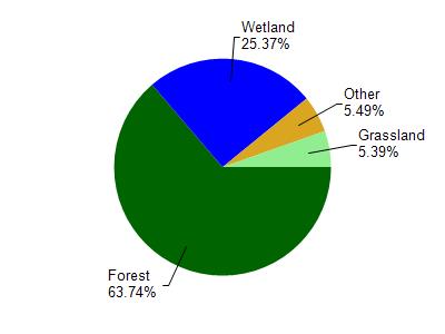
Denomie Creek is located in the Lower Bad River watershed which is 123.92 mi². Land use in the watershed is primarily forest (63.80%), wetland (25.40%) and a mix of grassland (5.40%) and other uses (5.50%). This watershed has 317.28 stream miles, 11,923.85 lake acres and 17,289.12 wetland acres.
Nonpoint Source Characteristics
This watershed is ranked Not Ranked for runoff impacts on streams, Not Available for runoff impacts on lakes and Low for runoff impacts on groundwater and therefore has an overall rank of Low. This value can be used in ranking the watershed or individual waterbodies for grant funding under state and county programs.However, all waters are affected by diffuse pollutant sources regardless of initial water quality. Applications for specific runoff projects under state or county grant programs may be pursued. For more information, go to surface water program grants.