Calumet
No
No
No
Fish and Aquatic Life
Overview
Hayton Pond is an impoundment of the South Branch of the Manitowoc River and covers 26.6 surface
acres. The maximum depth is 6 feet and the mean depth is 2.0 feet. The shoreline totals 2.05 miles, of
which 0.01 miles are publicly owned. The pond lies in a 104.0 square mile watershed. A few northern
pike and panfish are present, but carp, bullheads, and sucker and minnow species predominate (Kamke 1995).
In 1990, routine fish monitoring identified high levels of PCB in fish from a portion of the South Branch
Manitowoc River. Fish sampled showed PCB concentrations that exceeded state water quality standards and U.S. Food and Drug Administration (USFDA) human health fish consumption guidelines. A fish consumption advisory (Do Not Eat Any Fish) currently exists for the study area (See Health Advisory Map in protective sheets). An investigation of the water, sediment and fish tissues conducted between 1992 and 1994 identified contamination in eight miles of river stretching from Hayton Millpond, and impoundment on the South Branch Manitowoc River, through Pine Creek, a Hayton Millpond tributary, and Jordan Creek, a tributary to Pine Creek adjacent to the city of New Holstein. This area was selected by the WDNR as a priority sediment remediation demonstration project site. The study area is referred to as the Hayton Area Remediation Project (HARP).
A cleanup investigation began in January, 1995. Foth and Van Dyke, in association with Asci
Corporation, were selected by the WDNR and Wisconsin Department of Administration (WDOA) to
conduct a remedial investigation and feasibility study on select soils and sediments in Calumet County. Field sampling completed in August 1995 characterized the extent and magnitude of PCB contamination. The study suggests soil and sediments in drainage ditches in the northeast section of New Holstein are the source of the contamination. Field sampling will be conducted in 1996 to complete the characterization efforts. The WDNR is working in partnership with key stakeholders in the Hayton/New Holstein areas to complete characterization, conduct a feasibility study and develop a risk management strategy for PCB' s in the project area (Foth and Van Dyke 1996). For more information on the HARP site refer to the Remedial Investigation Report Hayton Area Remediation Project, February 1996, Volume I and II Text and Volume I and II Appendices.
Date 2002
Author Aquatic Biologist
Overview
Hayton Millpond is located in Calmet County near the Village of New Holstein. In the early 1990s, the WDNR found PCBs in Hayton Millpond and more than six miles upstream between the Village of New Holstein and the Millpond. The Killsnake Wildlife Area is immediately downstream of the millpond. Presently the WDNR and Tecumseh Products Company, working on a voluntary basis, have developed a remediation plan for the "source area" just north of the village. The PCB concentrations in the source area range from less than one mg/kg to 2,500 mg/kg.
As a first phase of this plan scheduled for 2000, all sediment with PCB concentrations of more than 50 mg/kg will be removed. The sediments will be properly disposed at a cost of about $700,000, with partial funding from the U.S. EPA Great Lakes National Program Office. Removal of additional PCB contaminated sediments in the source area is anticipated for 2001. Remediation plans for the downstream areas will likely be completed in 2001 or 2002. Issues that need to be resolved for the downstream areas include whether to remove sediment in major deposition areas along Pine Creek or construct a new channel to replace about four miles of natural stream channel. Another difficult issue is when and whether to remove the dam at Hayton.
Date 2000
Author Aquatic Biologist
Historical Description
Source: 1971, Surface Water Resources of Calumet County Hayton Pond, T18N, R20E, Section 16 (11), Area = 26.6 acres, Maximum depth = 6 feet, Secchi Disk = 1.5 feet.
Hayton Pond is an impoundment of the South Branch Manitowoc River containing turbid hard water. Water levels are maintained by a 6-foot head spillway type dam. The only access available is navigable water access via the inlet and outlet and walk-in access from U.S. Highway 151. The fishery consists of northern pike, bluegill, pumpkinseed, channel catfish, black bullhead, carp, white of common sucker, and redhorse. Carp are by far the most dominant species. Use problems include heavy algae blooms, carp, fluctuating water levels, and pollution in the form of silt and effluent from the Chilton Sewage Plant. The pond supports a significant muskrat population and a few migrant puddle ducks. Hunting is allowed. Developments consist of seven dwellings and a bar. It is surrounded by privately owned land and the dam is privately owned.
Date 1971
Author Surface Water Inventory Of Wisconsin
Condition
Wisconsin has over 84,000 miles of streams, 15,000 lakes and milllions of acres of wetlands. Assessing the condition of this vast amount of water is challenging. The state's water monitoring program uses a media-based, cross-program approach to analyze water condition. An updated monitoring strategy (2015-2020) is now available. Compliance with Clean Water Act fishable, swimmable standards are located in the Executive Summary of Water Condition in 2018. See also the 'monitoring and projects' tab.
Reports
Management Goals
Wisconsin's Water Quality Standards provide qualitative and quantitative goals for waters that are protective of Fishable, Swimmable conditions [Learn more]. Waters that do not meet water quality standards are considered impaired and restoration actions are planned and carried out until the water is once again fishable and swimmable
Management goals can include creation or implementation of a Total Maximum Daily Load analysis, a Nine Key Element Plan, or other restoration work, education and outreach and more. If specific recommendations exist for this water, they will be displayed below online.
Monitoring
Monitoring the condition of a river, stream, or lake includes gathering physical, chemical, biological, and habitat data. Comprehensive studies often gather all these parameters in great detail, while lighter assessment events will involve sampling physical, chemical and biological data such as macroinvertebrates. Aquatic macroinvertebrates and fish communities integrate watershed or catchment condition, providing great insight into overall ecosystem health. Chemical and habitat parameters tell researchers more about human induced problems including contaminated runoff, point source dischargers, or habitat issues that foster or limit the potential of aquatic communities to thrive in a given area. Wisconsin's Water Monitoring Strategy was recenty updated.
Grants and Management Projects
| Project Name (Click for Details) | Year Started |
|---|
|
|
Monitoring Projects
| WBIC | Official Waterbody Name | Station ID | Station Name | Earliest Fieldwork Date | Latest Fieldwork Date | View Station | View Data |
|---|
| 79800 | Hayton Pond 104 | 10001969 | Hayton Pond | 7/7/1992 | 8/25/2015 | Map | Data |
| 79800 | Hayton Pond 104 | 083057 | Hayton Pond - Middle | 4/27/1992 | 4/27/1992 | Map | Data |
|
Watershed Characteristics
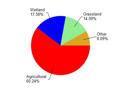
Hayton Pond 104 is located in the South Branch Manitowoc River watershed which is 189.10 mi². Land use in the watershed is primarily agricultural (60.30%), wetland (17.60%) and a mix of grassland (14.10%) and other uses (8.10%). This watershed has 228.03 stream miles, 86.31 lake acres and 21,287.68 wetland acres.
Nonpoint Source Characteristics
This watershed is ranked High for runoff impacts on streams, High for runoff impacts on lakes and High for runoff impacts on groundwater and therefore has an overall rank of High. This value can be used in ranking the watershed or individual waterbodies for grant funding under state and county programs.However, all waters are affected by diffuse pollutant sources regardless of initial water quality. Applications for specific runoff projects under state or county grant programs may be pursued. For more information, go to surface water program grants.