")
14.22 Miles
3 - 17.22
Cool-Cold Mainstem, Macroinvertebrate, Cool-Cold Headwater, Cool-Warm Mainstem, Coldwater, Cool-Warm Headwater
2013
Poor
High Phosphorus Levels
Total Phosphorus
Brown, Kewaunee
No
No
Yes
Fish and Aquatic Life
Overview
The Neshota River is a low gradient, low flow stream with fair water quality. Good bottom substrate is present in much of the river and the upper river likely supports a forage fish community, which includes the greater redhorse (Moxostoma valenciennesi), a threatened species. The lower three miles of the river have a warmwater sport fishery that is only partially supporting its use potential due to excessive sediment deposition, nutrient enrichment and turbidity from nonpoint sources of water pollution. Significant nonpoint sources in the watershed include cropland erosion, streambank pasturing and barnyard runoff. Poor manure management practices resulted in a large spill and subsequent fish kill in the middle 1990s. In addition, noxious materials from milkhouse drains are suspected of degrading surface and groundwater quality in the area. If nonpoint sources were controlled, this lower reach of stream could support a higher quality warmwater fishery.
Date 2001
Author Michael Toneys
Impaired Waters
Neshota River was recently evaluated during the ten-year period of 2009 through 2018 for results that were reported to the USEPA for the 2020 Clean Water Act condition report. The waterbody is considered impaired, or in poor condition for designated uses which include the quality of fish and aquatic life, recreational use, and public health and welfare (fish consumption and related). Pollutants or problems encountered during sampling (impairments) are determined based on water quality standards outlined in Wisconsin 2020 Consolidated Assessment and Listing Methodology (WisCALM). Assessment results show water conditions that are potentially harmful for Aquatic Life use due to values for total phosphorus that fall into the range expected for an aquatic community in poor health, therefore this water is listed as impaired.
Neshota River (mile 0-3): Assessment results during the 2020 listing cycle show impairment by total phosphorus. Levels were found to be too high for healthy aquatic communities (plants, bugs, fish, etc.) based on 2020 WisCALM standards; however, no biological impairment was observed (no fish or macroinvertebrate Index of Biotic Integrity scored in the poor condition category). Based on the most updated information, this segment was proposed for the impaired waters list in 2020.
Neshota River (mile 3-17.22): This segment was placed on the impaired waters list in 2012 for total phosphorus and no changes are needed.
Date 2019
Author Ashley Beranek
Condition
Wisconsin has over 84,000 miles of streams, 15,000 lakes and milllions of acres of wetlands. Assessing the condition of this vast amount of water is challenging. The state's water monitoring program uses a media-based, cross-program approach to analyze water condition. An updated monitoring strategy (2015-2020) is now available. Compliance with Clean Water Act fishable, swimmable standards are located in the Executive Summary of Water Condition in 2018. See also the 'monitoring and projects' tab.
Reports
Recommendations
Navigability Determination
NE SW S2 T22N R22E; King Creek, trib;
Navigability Determination
NE NE S8 T22N R22E; King Creek, trib;
Runoff Evaluation
In Manitowoc County, three of the five active barnyards in the watershed within 300 feet of a mapped stream need runoff control improvements. One needs to remove livestock access from stream.
Management Goals
Wisconsin's Water Quality Standards provide qualitative and quantitative goals for waters that are protective of Fishable, Swimmable conditions [Learn more]. Waters that do not meet water quality standards are considered impaired and restoration actions are planned and carried out until the water is once again fishable and swimmable
Management goals can include creation or implementation of a Total Maximum Daily Load analysis, a Nine Key Element Plan, or other restoration work, education and outreach and more. If specific recommendations exist for this water, they will be displayed below online.
Monitoring
Monitoring the condition of a river, stream, or lake includes gathering physical, chemical, biological, and habitat data. Comprehensive studies often gather all these parameters in great detail, while lighter assessment events will involve sampling physical, chemical and biological data such as macroinvertebrates. Aquatic macroinvertebrates and fish communities integrate watershed or catchment condition, providing great insight into overall ecosystem health. Chemical and habitat parameters tell researchers more about human induced problems including contaminated runoff, point source dischargers, or habitat issues that foster or limit the potential of aquatic communities to thrive in a given area. Wisconsin's Water Monitoring Strategy was recenty updated.
Grants and Management Projects
Monitoring Projects
| WBIC | Official Waterbody Name | Station ID | Station Name | Earliest Fieldwork Date | Latest Fieldwork Date | View Station | View Data |
|---|
| 88200 | Neshota River | 10039364 | Neshota River at Hwy T | | | Map | Data |
| 88200 | Neshota River | 10032657 | Neshota River at Maribel Rd. bridge | | | Map | Data |
| 88200 | Neshota River | 363269 | Neshota River - Hwy Bb | | | Map | Data |
| 88200 | Neshota River | 10040560 | Neshota River at Neshota Park in New Denmark (Denmark Eco Club site) | 5/25/2007 | 10/26/2013 | Map | Data |
| 88200 | Neshota River | 10010664 | Neshota River - 2 | 10/8/2002 | 10/8/2002 | Map | Data |
| 88200 | Neshota River | 053676 | Neshota River at Park Rd Near Denmark WI | 5/21/2002 | 10/15/2002 | Map | Data |
| 88200 | Neshota River | 10032656 | Neshota River below King Creek mouth | | | Map | Data |
| 88200 | Neshota River | 10010663 | Neshota River | | | Map | Data |
| 88200 | Neshota River | 10009869 | Neshota River Above Old Highway Kb | 5/4/1998 | 5/4/1998 | Map | Data |
|
Watershed Characteristics
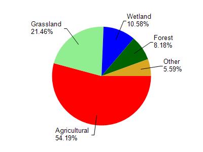
Neshota River is located in the West Twin River watershed which is 180.11 mi². Land use in the watershed is primarily agricultural (54.30%), grassland (21.50%) and a mix of wetland (10.60%) and other uses (13.80%). This watershed has 360.91 stream miles, 1,898.59 lake acres and 10,189.53 wetland acres.
Nonpoint Source Characteristics
This watershed is ranked High for runoff impacts on streams, Medium for runoff impacts on lakes and High for runoff impacts on groundwater and therefore has an overall rank of High. This value can be used in ranking the watershed or individual waterbodies for grant funding under state and county programs.This water is ranked High Stream for individual Rivers based on runoff problems and the likelihood of success from project implementation.
Neshota River is considered a Cool-Cold Mainstem, Macroinvertebrate, Cool-Cold Headwater, Cool-Warm Mainstem, Coldwater, Cool-Warm Headwater under the state's Natural Community Determinations.
Natural communities (stream and lake natural communities) represent model results and DNR staff valiation processes that confirm or update predicted conditions based on flow and temperature modeling from historic and current landscape features and related variables. Predicated flow and temperatures for waters are associated predicated fish assemblages (communities). Biologists evaluate the model results against current survey data to determine if the modeled results are corect and whether biological indicators show water quaity degradation. This analysis is a core component of the state's resource management framework. Wisconsin's Riverine Natural Communities.
Cool (Warm-Transition) Headwaters are small, sometimes intermittent streams with cool to warm summer temperatures. Coldwater fishes are uncommon to absent, transitional fishes are abundant to common, and warm water fishes are common to uncommon. Headwater species are abundant to common, mainstem species are common to absent, and river species are absent.
Cool (Cold-Transition) Mainstem streams are moderate-to-large but still wadeable perennial streams with cold to cool summer temperatures. Coldwater fishes are common to uncommon, transitional fishes are abundant to common, and warm water fishes are uncommon to absent. Headwater species are common to absent,
mainstem species are abundant to common, and river species are common to absent.
Cool (Cold-Transition) Headwaters are small, usually perennial streams with cold to cool summer temperatures. Coldwater fishes are common to uncommon (<10 per 100 m), transitional fishes are abundant to common, and warm water fishes are uncommon to absent. Headwater species are abundant to common, mainstem species are common to absent, and river species are absent.