Sheboygan
No
No
Yes
Fish and Aquatic Life
Overview
BARR CREEK AT LM 82.9 - OVERVIEW
T13N R23E Sec. 30 SWNE Stream Length = 7.2 WBIC = 50200
Barr Creek is a 7.2 mile-long Lake Michigan tributary originating northeast of Cedar Grove. Water quality is poor, influenced by three permitted dischargers, industrial storm water runoff in Cedar Grove, nutrients, bacteria, and cropland runoff from agricultural areas. Macroinvertebrate diversity is poor, with very tolerant organisms dominant, such as Asellus and Oligochaeta. The fish community lacks diversity, with white sucker, brassy minnow, fathead minnow, brook stickleback, black bullhead, and mudminnow dominant (Fago, 1985). Seasonal trout migration has been noted in spring fish surveys. Despite its steep gradient and gravel-rubble bottom, Barr Creek lacks typical headwaters species such as daces, stonerollers, darters and creek chubs.
Barr Creek was previously classified in 1979 as a non-continuous marginal fish and aquatic life stream (Limited Aquatic Life). This 1979 classification was proposed without the benefit of any widely accepted and scientifically based stream classification guidelines, or the use of recent biological information (i.e. fish survey results).
In 1986 and 1987, a wasteload allocation survey and waste assimilative model was completed for two discharges to Barr Creek, the Larson Company and Cedar Grove wastewater treatment plant. This survey and model was used to predict the combined waste assimilative capacity of Barr Creek and their effects on stream water quality. Concurrent with this survey, a stream classification survey was completed according to the 1982 Stream Classification Guidelines for Wisconsin. Measurements of in-stream habitat characteristics and fish surveys were completed.
The results of the 1986 stream classification indicate that Barr Creek habitat is suitable to sustain a viable population of tolerant to very tolerant forage fish, and lesser numbers of tolerant sport fish. Habitat was generally rated as “fair”. The results of fish surveys from 1986, and as early as 1976, confirmed this conclusion. The fish community was represented by seven species considered tolerant to very tolerant of degraded environmental conditions. The rainbow trout is not a resident of Barr Creek, but it along with other species of trout and salmon resident to Lake Michigan, probably migrate into Barr Creek on a seasonal basis. Due to natural limiting conditions (i.e. warm water temperatures), trout and salmon are not capable of reproducing in Barr Creek. Based on the results of the 1986 stream classification survey, it was recommended that Barr Creek be classified as a Limited Forage Fish Community. A subsequent Barr Creek fish survey in 1994 reinforced this stream classification (Table 18).
WDNR personnel surveyed Barr Creek upstream of the Cedar Grove Wastewater Treatment Plant in 1999 (river mile 2.2) and upstream of Sauk Trail Road (river mile 1.4) in 2000. Fish community, stream habitat, and benthic macroinvertebrates were surveyed and it was determined that while the stream habitat and available fish cover were good, the fish and macroinvertebrate communities were poor. This can probably be attributed to agricultural and urban land use in the watershed and poor water quality conditions within the stream. The water quality habitat ratings determined from the biological monitoring and habitat assessments from the 1994, 1999 and 2000 surveys are shown in Table 19.
Table 19. Hilsenhoff Biotic Index (HBI) and Index of Biotic Integrity (IBI) for Barr Creek, 1994, 1999 and 2000.
Barr Creek Sample Sites
Date 2001
Author Aquatic Biologist
Overview
Sediment Quality
Sediment collections were taken from an unnamed tributary to Barr Creek on the eastern side of Cedar Grove, upstream of CTH D. These samples were collected as part of the basin sediment survey to obtain baseline sediment quality data for Barr Creek and to assess the potential sediment quality impacts from the foundries adjacent the stream. An extensive oil sheen and oil product was observed in the stream during the sample collection despite the highly scoured substrate in the area (WDNR 1994). The results for total PCBs were just over the level of detect at 0.06 ug/g.
Eleven PAH compounds were detected in the sample collected in the unnamed tributary to Barr Creek in Cedar Grove (WDNR 1999). A storm water pollution prevention plan review of a foundry in Cedar Grove prompted a sediment survey of the stormsewer and tributary to Barr Creek (Triad Engineering Inc. 2000). No specific sediment management activities are planned at this time. Souce control will continue to be a focus.
Date 2001
Author Aquatic Biologist
Overview
BARR CREEK AT LM 82.9 - OVERVIEW - T13N R23E Sec. 30, Stream Length = 7.2
Barr Creek is a 7.2 mile-long Lake Michigan tributary originating northeast of Cedar Grove. Water quality is poor, influenced by three permitted dischargers, industrial stormwater runoff in Cedar Grove, nutrients, bacteria, and cropland runoff from agricultural areas. Macroinvertebrate diversity is poor, with very tolerant organisms dominant, such as Asellus and Oligochaeta. The fish community lacks diversity, with white sucker, brassy minnow, fathead minnow, brook stickleback, black bullhead, and mudminnow dominant (Fago, 1985). Seasonal trout migration has been noted in spring fish surveys. Despite its steep gradient and gravel-rubble bottom, Barr Creek lacks typical headwaters species such as daces, stonerollers, darters and creek chubs.
Barr Creek was previously classified in 1979 as a non-continuous marginal fish and aquatic life stream (Limited Aquatic Life). This 1979 classification was proposed without the benefit of any widely accepted and scientifically based stream classification guidelines, or the use of recent biological information (i.e. fish survey results).
In 1986 and 1987, a wasteload allocation survey and waste assimilative model was completed for two discharges to Barr Creek, the Larson Company and Cedar Grove wastewater treatment plant. This survey and model was used to predict the combined waste assimilative capacity of Barr Creek and their effects on stream water quality. Concurrent with this survey, a stream classification survey was completed according to the 1982 Stream Classification Guidelines for Wisconsin. Measurements of in-stream habitat characteristics and fish surveys were completed.
The results of the 1986 stream classification indicate that Barr Creek habitat is suitable to sustain a viable population of tolerant to very tolerant forage fish, and lesser numbers of tolerant sport fish. Habitat was generally rated as “fair”. The results of fish surveys from 1986, and as early as 1976, confirmed this conclusion. The fish community was represented by seven species considered tolerant to very tolerant of degraded environmental conditions. The rainbow trout is not a resident of Barr Creek, but it along with other species of trout and salmon resident to Lake Michigan, probably migrate into Barr Creek on a seasonal basis. Due to natural limiting conditions (i.e. warm water temperatures), trout and salmon are not capable of reproducing in Barr Creek. Based on the results of the 1986 stream classification survey, it was recommended that Barr Creek be classified as a Limited Forage Fish Community. A subsequent Barr Creek fish survey in 1994 reinforced this stream classification (Table 24).
During the 1994 water quality survey, two sites were sampled on Barr Creek and one site for sediment on a tributary to Barr creek. The water quality habitat ratings determined from the biological monitoring and habitat assessments ranged from fair to poor.
From: Galarneau, Steve and Masterson, John. 1999. Water Resources of the Sheboygan River Basin. Wisconsin Department of Natural Resources, Madison, WI.
Date 1999
Author Aquatic Biologist
Overview
Sediment Quality - Sediment collections were taken from an unnamed tributary to Barr Creek on the east side of Cedar Grove, upstream of CTH D (BRC-3). These samples were collected as part of the basin sediment survey to obtain baseline sediment quality data for Barr Creek and to assess the potential sediment quality impacts from the foundries adjacent the stream. An extensive oil sheen and oil product were observed in the stream during the sample collection despite the highly scoured substrate in the area (WDNR 1994). The results for total PCBs were just over the level of detect at 0.06 ug/g. Eleven PAH compounds were observed in the sample collected in the unnamed tributary to Barr Creek in Cedar Grove. The source of this contamination is unknown, but is probably from the foundries, which have poor yard practices and stormwater runoff to the stream. The tributary stream will be further evaluated for potential management activities.
From: Galarneau, Steve and Masterson, John. 2001. Water Resources of the Sheboygan River Basin. Wisconsin Department of Natural Resources, Madison, WI.
Date 1999
Author Aquatic Biologist
Management Goals
Wisconsin's Water Quality Standards provide qualitative and quantitative goals for waters that are protective of Fishable, Swimmable conditions [Learn more]. Waters that do not meet water quality standards are considered impaired and restoration actions are planned and carried out until the water is once again fishable and swimmable
Management goals can include creation or implementation of a Total Maximum Daily Load analysis, a Nine Key Element Plan, or other restoration work, education and outreach and more. If specific recommendations exist for this water, they will be displayed below online.
Monitoring
Monitoring the condition of a river, stream, or lake includes gathering physical, chemical, biological, and habitat data. Comprehensive studies often gather all these parameters in great detail, while lighter assessment events will involve sampling physical, chemical and biological data such as macroinvertebrates. Aquatic macroinvertebrates and fish communities integrate watershed or catchment condition, providing great insight into overall ecosystem health. Chemical and habitat parameters tell researchers more about human induced problems including contaminated runoff, point source dischargers, or habitat issues that foster or limit the potential of aquatic communities to thrive in a given area. Wisconsin's Water Monitoring Strategy was recenty updated.
Grants and Management Projects
| Project Name (Click for Details) | Year Started |
|---|
|
|
Monitoring Projects
| WBIC | Official Waterbody Name | Station ID | Station Name | Earliest Fieldwork Date | Latest Fieldwork Date | View Station | View Data |
|---|
| 50200 | Barr Creek | 10008151 | Barr Creek - Barr Creek - 180 M Upstream Sauk Trail Road - River Mile 1.4 | 12/8/1987 | 10/31/2016 | Map | Data |
| 50200 | Barr Creek | 603337 | Barr Creek - Upstream Of Sauk Trail | 3/30/1994 | 11/16/1994 | Map | Data |
| 50200 | Barr Creek | 10044728 | Barr Creek at Marine Road | 6/1/2016 | 10/12/2016 | Map | Data |
| 50200 | Barr Creek | 10015984 | Barr Cr. - Dwnstm Hwy I-43 | 12/8/1987 | 12/8/1987 | Map | Data |
| 50200 | Barr Creek | 10008134 | Barr Creek | 10/20/1999 | 12/2/1999 | Map | Data |
|
Watershed Characteristics
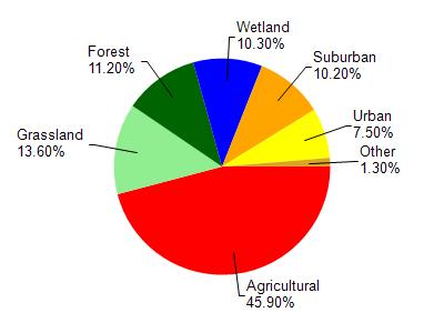
Barr Creek is located in the Black River watershed which is 35.51 mi². Land use in the watershed is primarily agricultural (45.90%), grassland (13.60%) and a mix of forest (11.20%) and other uses (29.30%). This watershed has 83.77 stream miles, 6,359.43 lake acres and 2,238.69 wetland acres.
Nonpoint Source Characteristics
This watershed is ranked High for runoff impacts on streams, Not Ranked for runoff impacts on lakes and High for runoff impacts on groundwater and therefore has an overall rank of High. This value can be used in ranking the watershed or individual waterbodies for grant funding under state and county programs.However, all waters are affected by diffuse pollutant sources regardless of initial water quality. Applications for specific runoff projects under state or county grant programs may be pursued. For more information, go to surface water program grants.