Fond Du Lac
No
No
No
Fish and Aquatic Life
Overview
GILTNER'S LAKE
T16N, R19E, Section 15, Fond Du Lac County, Sheboygan River Watershed
Surface Acres = 17.3, S.D.F. = 1.30, Maximum Depth = 13 feet
Giltner's is a small, hard water lake with a maximum depth of 13 feet. It is a shallow, fertile, marshy lake with an intermittent outlet to Wolf Lake. Although fish kills occur occasionally from both winter kill and summer kill, the lake is restocked by migration of native species entering from Wolf Lake during periods of high flow. Perch and bullheads are commonly harvested but fishing pressure is light due to lack of public access and intermittent fishing quality. Cattle watering and pasturing create a fertility problem and the lake frequently experiences heavy blooms of algae. Mallard and teal nest in the 30 acres of associated marsh, which is also home to numerous muskrats. There is no public access to the lake, although the owner allows fishing by permission. Waterfowl uses are significant and hunting is common. Very little management occurs at present. Preservation of the existing undeveloped status is desirable. Public ownership would prevent development from occurring and the recreational potential could be greatly enhanced.
Management of small shallow eutrophic lakes poses significant problems for managers. The inherent qualities of Giltner’s Lake should direct management efforts. Because of the history of winterkill the lakes fishery may be considered either boom or bust. The wildlife value and aesthetic quality of the lake is perhaps its most permanent asset.
Water quality monitoring was conducted as part of the 1994 Sheboygan Basin Monitoring. Permission to monitor Giltner’s Lake as obtained from Mr. Vic Steffas who is the local property owner. Mr. Steffas indicated that the lake had a substantial winterkill during the 1993-94 winter. Prior to the winterkill the lake supported a good yellow perch fishery. Several small bullheads were observed dead on the shore on the May sample date.
The private launch site is located at the end of a gravel road leading to the lake. While there is no ramp the substrate is solid and supported the Departments boat and trailer without any difficulty. The water depth at the launch site is adequate however the launch site periodically gets plugged with cattail mats that are broken from the adjacent shoreline.
Aquatic Plants
An unidentified narrow leaf pondweed (Potamogeton sp.), Coontail (Ceratophyllum demersum), and Yellow Water Lily (Nuphar sp.) were observed during a general survey of aquatic vegetation. The shoreline has extensive Cattail growth which provides good wildlife habitat.
Date 2001
Author Aquatic Biologist
Overview
Water Quality
The water quality of Giltner’s Lake was monitored on May 12, and September 13, 1994. In May, the lake was slightly stratified with only a 1.8-degree difference from top to bottom. In May, the dissolved oxygen profile ranged from 10.3 ppm at the surface to 4.0 on the bottom. In September, the lake was moderately stratified with a 4.0-degree stratification factor and a thermocline between 5 and 10 feet. Dissolved oxygen was 0.1 ppm at 10 feet and 0 at the bottom (13-ft). The water clarity was 0.7 meters and 0.1 meters in May and September respectively. The chlorophyll a was 43.6 ug/l at the surface in May and 325 ug/l in September (Wakeman 1996).
Trophic Status Index
There is very limited water quality data available on Giltner’s Lake. Based upon the spring and summer sampling conducted in 1994 the trophic status index of Giltner’s Lakes is classified as Eutrophic (Figure 14). This classification is reflective of the tremendous algae bloom, poor secchi depth and nutrient levels observed in the lake. Depending upon the extent of the fish kill observed by the property owner during the 1993-94 winter, the water quality condition of the lake during the 1994 monitoring year would likely be affected by the fish kill. The trophic status index may be very different following a year without a fish kill.
Date 2001
Author Aquatic Biologist
Historical Description
Source: 1969, Surface Water Resources of Fond du Lac County
Giltner's Lake, T16N, R19E, Section 15
Surface Acres = 17.3, S.D.F. = 1.30, Maximum Depth = 13 feet
A shallow, fertile, marshy lake with an intermittent outlet
to Wolf Lake. It suffers from both winterkill and summerkill,
but is naturally restocked with fish entering from Wolf Lake.
The fish population consists primarily of bullheads, northern
pike, carp and perch. Cattle watering and pasturing creates a
fertility problem and the lake frequently experiences heavy
blooms of algae. Mallard and teal nest in the 30 acres of
associated marsh which is also home to numerous muskrats. There
is no public access to the lake, although the owner allows
fishing by permission.
Date 1969
Author Surface Water Inventory Of Wisconsin
Condition
Wisconsin has over 84,000 miles of streams, 15,000 lakes and milllions of acres of wetlands. Assessing the condition of this vast amount of water is challenging. The state's water monitoring program uses a media-based, cross-program approach to analyze water condition. An updated monitoring strategy (2015-2020) is now available. Compliance with Clean Water Act fishable, swimmable standards are located in the Executive Summary of Water Condition in 2018. See also the 'monitoring and projects' tab.
Reports
Management Goals
Wisconsin's Water Quality Standards provide qualitative and quantitative goals for waters that are protective of Fishable, Swimmable conditions [Learn more]. Waters that do not meet water quality standards are considered impaired and restoration actions are planned and carried out until the water is once again fishable and swimmable
Management goals can include creation or implementation of a Total Maximum Daily Load analysis, a Nine Key Element Plan, or other restoration work, education and outreach and more. If specific recommendations exist for this water, they will be displayed below online.
Monitoring
Monitoring the condition of a river, stream, or lake includes gathering physical, chemical, biological, and habitat data. Comprehensive studies often gather all these parameters in great detail, while lighter assessment events will involve sampling physical, chemical and biological data such as macroinvertebrates. Aquatic macroinvertebrates and fish communities integrate watershed or catchment condition, providing great insight into overall ecosystem health. Chemical and habitat parameters tell researchers more about human induced problems including contaminated runoff, point source dischargers, or habitat issues that foster or limit the potential of aquatic communities to thrive in a given area. Wisconsin's Water Monitoring Strategy was recenty updated.
Grants and Management Projects
Monitoring Projects
| WBIC | Official Waterbody Name | Station ID | Station Name | Earliest Fieldwork Date | Latest Fieldwork Date | View Station | View Data |
|---|
| 60900 | Giltners Lake | 10042280 | Giltners Lake - Deep Hole | 6/18/2024 | 6/16/2026 | Map | Data |
| 60900 | Giltners Lake | 10002488 | Giltners Lake | 7/27/1999 | 9/30/2017 | Map | Data |
|
Watershed Characteristics
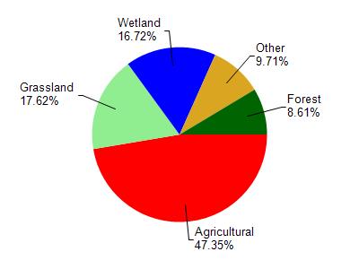
Giltners Lake is located in the Sheboygan River watershed which is 260.12 mi². Land use in the watershed is primarily agricultural (47.30%), grassland (17.60%) and a mix of wetland (16.70%) and other uses (18.30%). This watershed has 340.24 stream miles, 4,345.33 lake acres and 27,968.05 wetland acres.
Nonpoint Source Characteristics
This watershed is ranked Not Available for runoff impacts on streams, Not Available for runoff impacts on lakes and High for runoff impacts on groundwater and therefore has an overall rank of High. This value can be used in ranking the watershed or individual waterbodies for grant funding under state and county programs.However, all waters are affected by diffuse pollutant sources regardless of initial water quality. Applications for specific runoff projects under state or county grant programs may be pursued. For more information, go to surface water program grants.