Rock
Yes
No
No
Fish and Aquatic Life
Overview
Rock River Water Quality Management Plan, Lower Rock River Appendix. WT-668-2002. South Central Region, WDNR.
Spring Creek is a small spring-fed tributary of medium grade (16 feet/mile) that connects with Badfish Creek near Cooksville. Historically, Spring Creek was managed for trout, but ditching and polluted runoff reduced it by the mid-1980s to supporting a warm water forage fishery. In 1990, Spring Creek reappeared as a trout water in the “Trout Fishing Regulations and Guide.”
As of 1996, Spring Creek is considered a Class III Trout Stream supporting brown trout; the stream's potential, however, is Class II. The effects of stream channelization and polluted runoff in the stream's six-square-mile agricultural watershed--particularly from streambank pasturing (erosion) and barnyard runoff--have taken their toll. Runoff from up-slope cultivated fields represents 95 percent of the total sediment load to streams in the watershed, which is 86 percent agricultural with row cropping the primary enterprise (83 percent of total acres). Up-slope runoff also contributes nitrate to groundwater (WDNR, 1993a).
Spring Creek was selected as a nonpoint source priority watershed project and a water resources appraisal was prepared in 1993 (WDNR, 1993b). For purposes of analysis, the stream is divided into two segments: from its headwaters to Murray Road is segment 1; east of Murray Road is considered segment 2. Segment 1 has been extensively channelized and thus exhibits habitat loss; by the mid-1950s the stream no longer supported trout. Recent land use changes have restored a buffer strip along this segment's streambanks, allowing development of riparian habitat and ecological recovery. Heavy sediment persists, however, on the stream bottom, which has accumulated during previous years' runoff and low flow conditions (WDNR, 1993b).
Segment 2 has retained its natural stream hydrology, but heavy pasturing and streambank erosion stifle the stream's functional values. Eroded streams and embeddedness reduce suitable habitat for insects and spawning fish (WDNR, 1993a). Streambanks contribute the remaining 5 percent of the overall sediment delivered to the watershed. The priority watershed plan's target goal is to reduce by 75 percent the total tons delivered from streambanks annually and restore 50 percent of the riparian habitat.
In addition, high bacteria and nutrient loads persist from poor feedlot and manure management practices. An 85 percent reduction in animal feedlot runoff from throughout the watershed is necessary to meet the priority watershed plan's stated objectives (WDNR, 1993a).
Date 2002
Author Aquatic Biologist
Historical Description
Bush, D.M., R. Cornelius, D. Engle, and C.L. Brynildson. 1980. Lake and Stream Classification Project. Surface Water Resources of Green County, 2nd Edition. Wisconsin Department of Natural Resources, Madison, Wisconsin.
Originating near the Illinois-Wisconsin border. this warm water creek is joined by one unnamed stream and flows northwest to enter Honey Creek. Spring Creek runs through cropland and pasture and bank erosion is moderate to heavy in the pastured areas. The stream is wide and shallow and the water generally runs turbid. The bottom is approximately 60 percent gravel and 40 percent silt and muck.
The Spring Creek fishery consists of forage species dominated by the central stoneroller. Wildlife values are limited to a few muskrats and public access is available from two county road crossings.
Fish Species: .Central stoneroller, stoneroller x southern redbe)ly dace hybrid, brassy minnow, common shiner
x southern redbelly dace hybrid, bigmouth shiner, southern redbelly dace, bluntnose minnow, fathead minnow, creek chub, white sucker, brook stickleback, Johnny darter.
Surface Acres = 3.3. Length = 3.4 Miles. Gradient = 28 ft./mi.. Base Discharge = 4.3 cu ft./sec.
Date 1980
Author Surface Water Inventory Of Wisconsin
Historical Description
From: Ball, Joseph R., and Ronald J. Poff, Lake and Stream Classification Project. Surface Water Resources of Rock County, Department of Natural Resources, 1970.
Surface Acres = 1.3, Miles = 2.75, Gradient = 16 feet per mile.
A small spring fed stream originating northeast of Evansville and flowing in a northeasterly direction to Badfish Creek. Once managed for trout but now supports only forage species. Ditching in the upper portion of the stream was partly responsible for increased water temperatures and habitat deterioration. Adjoining fresh meadow wetland totals 430 acres but has little waterfowl or marsh furbearer value. Access is available from one town road and two state highway crossings.
Date 1970
Author Surface Water Inventory Of Wisconsin
Condition
Wisconsin has over 84,000 miles of streams, 15,000 lakes and milllions of acres of wetlands. Assessing the condition of this vast amount of water is challenging. The state's water monitoring program uses a media-based, cross-program approach to analyze water condition. An updated monitoring strategy (2015-2020) is now available. Compliance with Clean Water Act fishable, swimmable standards are located in the Executive Summary of Water Condition in 2018. See also the 'monitoring and projects' tab.
Reports
Recommendations
Nine Key Element Plan
Spring Creek PWS Plan - Nine Key Element Plan - The Spring Creek Priority Watershed Project plan assesses the nonpoint sources of pollution in the Spring Creek Watershed and guides the implementation of nonpoint source control measures. These control measures are needed to meet specific water resource objectives for Spring Creek and its tributaries. The purpose of this project is to reduce the amount of pollutants originating from nonpoint sources that reach surface water and groundwater within the Spring Creek Priority Watershed Project area.
Management Goals
Wisconsin's Water Quality Standards provide qualitative and quantitative goals for waters that are protective of Fishable, Swimmable conditions [Learn more]. Waters that do not meet water quality standards are considered impaired and restoration actions are planned and carried out until the water is once again fishable and swimmable
Management goals can include creation or implementation of a Total Maximum Daily Load analysis, a Nine Key Element Plan, or other restoration work, education and outreach and more. If specific recommendations exist for this water, they will be displayed below online.
Monitoring
Monitoring the condition of a river, stream, or lake includes gathering physical, chemical, biological, and habitat data. Comprehensive studies often gather all these parameters in great detail, while lighter assessment events will involve sampling physical, chemical and biological data such as macroinvertebrates. Aquatic macroinvertebrates and fish communities integrate watershed or catchment condition, providing great insight into overall ecosystem health. Chemical and habitat parameters tell researchers more about human induced problems including contaminated runoff, point source dischargers, or habitat issues that foster or limit the potential of aquatic communities to thrive in a given area. Wisconsin's Water Monitoring Strategy was recenty updated.
Grants and Management Projects
Monitoring Projects
| WBIC | Official Waterbody Name | Station ID | Station Name | Earliest Fieldwork Date | Latest Fieldwork Date | View Station | View Data |
|---|
| 799900 | Spring Creek | 10010446 | Spring Creek - Spring Creek 18m Upstream Hwy 59 | 10/10/1985 | 9/16/1999 | Map | Data |
| 799900 | Spring Creek | 10010527 | Spring Creek | | | Map | Data |
| 799900 | Spring Creek | 10009947 | Spring Creek - Spring Creek Mouth Upstream | 1/1/2015 | 1/1/2015 | Map | Data |
| 799900 | Spring Creek | 543262 | Spring Creek Site #1 at Sth 59 Near Cooksville WI | 10/4/1993 | 10/4/1993 | Map | Data |
| 799900 | Spring Creek | 10016334 | Spring Cr. at Private Dr Off Of E. Union | 5/11/1993 | 5/11/1993 | Map | Data |
| 799900 | Spring Creek | 10010528 | Spring Creek | | | Map | Data |
| 799900 | Spring Creek | 10010526 | Spring Creek | | | Map | Data |
| 799900 | Spring Creek | 10010525 | Spring Creek | | | Map | Data |
| 799900 | Spring Creek | 10034815 | Spring Creek - Hunt Club Pond to Culvert | 1/1/2015 | 1/1/2015 | Map | Data |
| 799900 | Spring Creek | 10053319 | Rock 1 Spring, Spring Creek | 8/5/2014 | 6/11/2019 | Map | Data |
| 799900 | Spring Creek | 10012804 | Spring Creek 2 | | | Map | Data |
| 799900 | Spring Creek | 10016455 | Spring Creek - Bullard Rd Crossing Downstream | 5/11/1993 | 5/5/1994 | Map | Data |
| 799900 | Spring Creek | 543268 | Spring Creek - Hwy 59 Bridge | 4/24/1992 | 8/16/2023 | Map | Data |
| 799900 | Spring Creek | 10056929 | Spring Cr ~ 50m off E. Union Rd | | | Map | Data |
| 799900 | Spring Creek | 10009946 | Spring Creek Below N. Murray Rd | 4/24/1992 | 6/14/2026 | Map | Data |
| 799900 | Spring Creek | 10010531 | Spring Creek | | | Map | Data |
| 799900 | Spring Creek | 10010530 | Spring Creek (1) Upstream Of Badfish Creek | 5/15/1995 | 9/16/1999 | Map | Data |
|
Watershed Characteristics
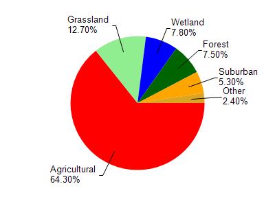
Spring Creek is located in the Badfish Creek watershed which is 84.21 mi². Land use in the watershed is primarily agricultural (64.30%), grassland (12.70%) and a mix of wetland (7.80%) and other uses (15.20%). This watershed has 78.94 stream miles, 217.98 lake acres and 3,799.54 wetland acres.
Nonpoint Source Characteristics
This watershed is ranked Medium for runoff impacts on streams, Not Ranked for runoff impacts on lakes and High for runoff impacts on groundwater and therefore has an overall rank of High. This value can be used in ranking the watershed or individual waterbodies for grant funding under state and county programs.This water is ranked High Stream for individual Rivers based on runoff problems and the likelihood of success from project implementation.