Marathon
No
No
No
Fish and Aquatic Life
Overview
Lake Wausau, T28N, R7E, Section 24 Surface Acres = 1,918.0, Maximum Depth = 30 feet, Secchi Disk = 3 feet
Lake Wasua soft water drainage lake (impoundment) having slightly acid, medium brown water. The entire shoreline is upland. Littoral materials consist of sand (75 percent), muck (20 percent), and rubble (5 percent). The growth of aquatic vegetation is moderate in quantity. Fish inhabiting the lake include muskellunge, northern pike, walleye, largemouth bass, smallmouth bass, yellow perch, bluegill, black crappie, rock bass, pumpkinseed, black bullhead, white sucker, and northern redhorse. Waterfowl make use of this flowage, especially on fall migrations, due to city imposed restrictions on hunting. Of the lake's 73.9 miles of shoreline, 5.5 miles are in public ownership. Eight public boat landings, some with parking, have been provided. Shoreline developments include numerous city and county parks and 127 dwellings. Inlet streams include the Rib River, the Eau Claire River, and the Wisconsin River. The outlet, the Wisconsin River, flows to the Mosinee Flowage. The water control structure, owned by the Wisconsin Public Service Corporation, is used to generate electric power. The dam has a head of 27 feet.
Source: 1977, Surface Water Resources of Marathon County
Date 1977
Author Aquatic Biologist
Recommendations
Sewer Service Area Planning
The Wausau Urban Area 2025 Sewer Service Area (SSA) Plan updates planning goals, objectives, and procedures, and expands the sewer service area by adding 12,823 acres, for a new total SSA of 53, 271 acres. Initially, approximately 29% of this area (15,271 acres) will be undeveloped. The SSA excludes wetlands, floodplain and steep slope areas that are considered "environmentally sensitive areas". The plan update has been adopted by the Marathon County Metropolitan Planning Commission. The approval of this sewer service area amendment does not constitute approval of any other local, state, or federal permit that may be required for sewer construction or associated land development activities.
Management Goals
Wisconsin's Water Quality Standards provide qualitative and quantitative goals for waters that are protective of Fishable, Swimmable conditions [Learn more]. Waters that do not meet water quality standards are considered impaired and restoration actions are planned and carried out until the water is once again fishable and swimmable
Management goals can include creation or implementation of a Total Maximum Daily Load analysis, a Nine Key Element Plan, or other restoration work, education and outreach and more. If specific recommendations exist for this water, they will be displayed below online.
Monitoring
Monitoring the condition of a river, stream, or lake includes gathering physical, chemical, biological, and habitat data. Comprehensive studies often gather all these parameters in great detail, while lighter assessment events will involve sampling physical, chemical and biological data such as macroinvertebrates. Aquatic macroinvertebrates and fish communities integrate watershed or catchment condition, providing great insight into overall ecosystem health. Chemical and habitat parameters tell researchers more about human induced problems including contaminated runoff, point source dischargers, or habitat issues that foster or limit the potential of aquatic communities to thrive in a given area. Wisconsin's Water Monitoring Strategy was recenty updated.
Grants and Management Projects
Monitoring Projects
| WBIC | Official Waterbody Name | Station ID | Station Name | Earliest Fieldwork Date | Latest Fieldwork Date | View Station | View Data |
|---|
| 1437500 | Lake Wausau | 118 | Wisconsin River at Lake Wausau | 10/13/1970 | 10/6/2019 | Map | Data |
| 1451800 | Big Rib River | 373196 | Big Rib River - 25' Sw Of Northern End Of Hwy 51 Bridge | 10/28/1992 | 10/28/1992 | Map | Data |
| 1437500 | Lake Wausau | 10018354 | Lake Wausau - Access Nr Oriole Ln / Bluegill Bay Cty Park | 6/12/2007 | 8/19/2023 | Map | Data |
| 1469700 | Wausau Dam Lake | 10014604 | Wisconsin River | 7/24/2006 | 9/30/2017 | Map | Data |
| 1437500 | Lake Wausau | 373277 | Lake Wausau - Below Asylum Point Wausau - Lake Wausau | 8/16/1976 | 8/10/2004 | Map | Data |
| 1437500 | Lake Wausau | 373276 | Wisconsin River - 1/4 Mi Below Cth N Bridge | 6/21/1977 | 7/22/2014 | Map | Data |
| 1179900 | Wisconsin River | 373276 | Wisconsin River - 1/4 Mi Below Cth N Bridge | 6/21/1977 | 7/22/2014 | Map | Data |
| 1437500 | Lake Wausau | 10003621 | Lake Wausau | 10/27/1981 | 6/23/2018 | Map | Data |
| 1437500 | Lake Wausau | 10046857 | Lake Wausau below Hwy 29 | 7/25/2016 | 5/24/2021 | Map | Data |
| 1451800 | Big Rib River | 373432 | Big Rib River - In Oxbow Ws-6 | 1/2/1997 | 6/25/2001 | Map | Data |
| 1437500 | Lake Wausau | 10049545 | Wisconsin River 70yds usptream of spill | 1/23/2018 | 8/6/2025 | Map | Data |
| 1437500 | Lake Wausau | 10034052 | Lake Wausau 2011 HBA sample 2 | 8/2/2011 | 8/4/2011 | Map | Data |
| 1179900 | Wisconsin River | 10018556 | Wisconsin River - Lake Wausau -- Access - Nr River Drive | 5/9/2009 | 7/1/2020 | Map | Data |
| 1437500 | Lake Wausau | 10059170 | Pine Island SW site 2 | 7/15/2002 | 7/15/2002 | Map | Data |
| 1437500 | Lake Wausau | 373434 | Wausau Lake - Site 2 West Chanl | 6/21/1989 | 8/26/2012 | Map | Data |
| 1437500 | Lake Wausau | 10018164 | Lake Wausau -- Access at 3rd Ave | 7/22/2005 | 6/30/2019 | Map | Data |
| 1437500 | Lake Wausau | 373279 | Wisconsin River at Mouth Of Rib R-Wausau | 6/22/1977 | 6/21/2023 | Map | Data |
| 1179900 | Wisconsin River | 373025 | Wisconsin River - A Boat Ldg Bl Wausau Stp | 8/8/1977 | 8/8/1977 | Map | Data |
| 1437500 | Lake Wausau | 10049547 | Wisconsin River 75 yds Downstream of Discharge | 1/23/2018 | 8/6/2025 | Map | Data |
| 1437500 | Lake Wausau | 10057740 | Eau Claire River @ S Grand Ave (Below Dam) | 6/21/2023 | 6/21/2023 | Map | Data |
| 1451800 | Big Rib River | 373447 | Big Rib River - Oxbow Nw Corner Near Shore | | | Map | Data |
| 1437500 | Lake Wausau | 10014604 | Wisconsin River | 7/24/2006 | 9/30/2017 | Map | Data |
| 1437500 | Lake Wausau | 10049534 | Thomas Street Bridge | 1/24/2018 | 8/6/2025 | Map | Data |
| 1179900 | Wisconsin River | 373009 | Wisconsin River - Wausau Stp | 6/5/1974 | 4/5/1978 | Map | Data |
| 1437500 | Lake Wausau | 10059171 | Pine Island SW Site 1 | 7/15/2002 | 7/15/2002 | Map | Data |
| 1437500 | Lake Wausau | 373435 | Wausau Lake - Site 3 Asylum Pt | 6/21/1989 | 8/26/2012 | Map | Data |
| 1437500 | Lake Wausau | 10046870 | Wisconsin River at River Side Park | 7/25/2016 | 9/21/2022 | Map | Data |
| 1437500 | Lake Wausau | 10018355 | Lake Wausau -- Access Off Bluegill Ave | 7/18/2003 | 7/16/2021 | Map | Data |
| 1451800 | Big Rib River | 10021951 | Big Rib River/Lake Wausau -- Access At Mallard Lane | 8/8/2007 | 7/13/2012 | Map | Data |
| 1437500 | Lake Wausau | 10021953 | Lake Wausau -- Kort Street Boat Launch | 8/27/2007 | 6/30/2019 | Map | Data |
| 1437500 | Lake Wausau | 10044343 | Rookery View Park | 7/19/2014 | 7/19/2014 | Map | Data |
| 1437500 | Lake Wausau | 373025 | Wisconsin River - A Boat Ldg Bl Wausau Stp | 8/8/1977 | 8/8/1977 | Map | Data |
| 1451800 | Big Rib River | 373431 | Big Rib River - In Oxbow Ws-5 /156 Ft Nw Of 373430 | | | Map | Data |
| 1451800 | Big Rib River | 373427 | Big Rib River - 120 Ft Upst Of Mouth Of Wausau Steel Oxbow | 1/2/1997 | 6/25/2001 | Map | Data |
| 1437500 | Lake Wausau | 10044342 | Goose Ln and N, directly east in the bay | 7/19/2014 | 7/19/2014 | Map | Data |
| 1179900 | Wisconsin River | 10046857 | Lake Wausau below Hwy 29 | 7/25/2016 | 5/24/2021 | Map | Data |
| 1437500 | Lake Wausau | 10059167 | Island N of Memorial Park boat launch | 7/15/2002 | 7/15/2002 | Map | Data |
| 1451800 | Big Rib River | 373428 | Big Rib River - In Oxbow Ws-2 | 1/2/1997 | 6/25/2001 | Map | Data |
| 1437500 | Lake Wausau | 373297 | Lake Wausau - 3/4 Mi Above L Wausau Dam - Lake Wausau | 8/17/1975 | 10/6/2019 | Map | Data |
| 1451800 | Big Rib River | 373429 | Big Rib River - In Oxbow Ws-3 /360 Ft N. Of Outlet To River | 1/2/1997 | 6/25/2001 | Map | Data |
| 1179900 | Wisconsin River | 10014604 | Wisconsin River | 7/24/2006 | 9/30/2017 | Map | Data |
| 1437500 | Lake Wausau | 10049542 | Wiscosnin River Bluegill Park | | | Map | Data |
| 1179900 | Wisconsin River | 10017187 | Wisconsin River-1/4 Mile Below Wausau Dam - West S Ide Near Swim Pool. | 4/24/1980 | 10/23/1980 | Map | Data |
| 1437500 | Lake Wausau | 10034062 | Memorial Park Boat Ramp | 7/25/2011 | 7/23/2020 | Map | Data |
| 1437500 | Lake Wausau | 10049546 | Wisconsin River Outlet of Discharge | 1/23/2018 | 8/6/2025 | Map | Data |
| 1179900 | Wisconsin River | 10012472 | Wisconsin River At Oak Island Park | 7/5/2001 | 7/5/2001 | Map | Data |
| 1437500 | Lake Wausau | 373433 | Wausau Lake - Site 1 East Basin | 6/19/1989 | 8/26/2012 | Map | Data |
| 1451800 | Big Rib River | 373441 | Big Rib River - 120 Ft Dnst Of Mouth Of Wausau Steel Oxbow | 3/11/1999 | 6/25/2001 | Map | Data |
| 1179900 | Wisconsin River | 373337 | Wisconsin River - Below Rothschild Dam | 8/18/1977 | 3/29/2011 | Map | Data |
| 1451800 | Big Rib River | 373197 | Big Rib River - 1st Slough Nw Of Hwy 51 Bridge | 10/28/1992 | 10/28/1992 | Map | Data |
| 1451800 | Big Rib River | 373430 | Big Rib River - In Oxbow Ws-4 /100 Ft Nw Of 373429 | 1/2/1997 | 6/25/2001 | Map | Data |
|
Watershed Characteristics
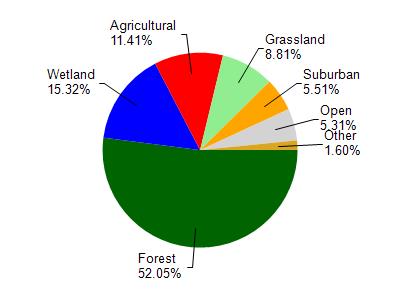
Lake Wausau is located in the Mosinee Flowage watershed which is 81.83 mi². Land use in the watershed is primarily forest (52%), wetland (15.30%) and a mix of agricultural (11.40%) and other uses (21.20%). This watershed has stream miles, lake acres and 7,457.82 wetland acres.
Nonpoint Source Characteristics
This watershed is ranked Medium for runoff impacts on streams, Low for runoff impacts on lakes and High for runoff impacts on groundwater and therefore has an overall rank of High. This value can be used in ranking the watershed or individual waterbodies for grant funding under state and county programs.However, all waters are affected by diffuse pollutant sources regardless of initial water quality. Applications for specific runoff projects under state or county grant programs may be pursued. For more information, go to surface water program grants.