Shawano
No
No
No
Fish and Aquatic Life
Overview
The main stem of the Embarrass River extends from Caroline in Shawano County, east and southward through Waupaca and Outagamie Counties to New London where it flows into the Wolf River. Major tributaries to the main stem include the Pigeon River, Mill, Maple, and Bear creeks. The river has a diverse fishery and is best known for its smallmouth bass. In addition to its fishery, the river also offers canoeing. The main stem of the Embarrass River is also an important sturgeon spawning stream up to the Pella Dam. Soil erosion rates in the watershed are critical, especially in the Grant Township area, with animal waste runoff also a problem.
From: Bougie, Cheryl A., Kosmond, Lisa D, and Watermolen, Dreux J. 1996. Wolf River Basin Water Quality Management Plan. Wisconsin Department of Natural Resources, Madison, WI.
Date 1996
Author Cheryl Bougie
Historical Description
Embarrass River, T22N, RISE, Sec. 7(6), Area = 264.7 acres, Length = 27.3 miles, M.P.A. = 187 ppm.
The Embarrass River is one of Outagamie County's most important surface water resources. The river drains
the northwest corner of the county and contains hard, turbid water. The bottom consists mostly of firm sand
and silt in Outagamie County. The stream is best known for its smallmouth bass fishery. Other species
present include walleye, northern pike, various panfish, and an abundant supply of carp. Game use of the
area is very heavy by deer, waterfowl, furbearers, and an abundance of small game. The entire river is slow
and smooth flowing throughout Outagamie County. This river is a popular canoe route because it is scenic and
well suited for the amateur canoeist. Access is difficult within the county. One state, two county, and
three town road crossings or endings without parking provide the only public access.
From: Nelson, Linden M. and Ronald L. Fassbender, 1972. Surface Water Resources of Outagamie County:
Lake and Stream Classification Project. Wisconsin Department of Natural Resources, Madison, WI.
Date 1972
Author Surface Water Inventory Of Wisconsin
Management Goals
Wisconsin's Water Quality Standards provide qualitative and quantitative goals for waters that are protective of Fishable, Swimmable conditions [Learn more]. Waters that do not meet water quality standards are considered impaired and restoration actions are planned and carried out until the water is once again fishable and swimmable
Management goals can include creation or implementation of a Total Maximum Daily Load analysis, a Nine Key Element Plan, or other restoration work, education and outreach and more. If specific recommendations exist for this water, they will be displayed below online.
Monitoring
Monitoring the condition of a river, stream, or lake includes gathering physical, chemical, biological, and habitat data. Comprehensive studies often gather all these parameters in great detail, while lighter assessment events will involve sampling physical, chemical and biological data such as macroinvertebrates. Aquatic macroinvertebrates and fish communities integrate watershed or catchment condition, providing great insight into overall ecosystem health. Chemical and habitat parameters tell researchers more about human induced problems including contaminated runoff, point source dischargers, or habitat issues that foster or limit the potential of aquatic communities to thrive in a given area. Wisconsin's Water Monitoring Strategy was recenty updated.
Grants and Management Projects
| Project Name (Click for Details) | Year Started |
|---|
|
|
Monitoring Projects
| WBIC | Official Waterbody Name | Station ID | Station Name | Earliest Fieldwork Date | Latest Fieldwork Date | View Station | View Data |
|---|
| 291900 | Embarrass River | 10052089 | Embarrass River 5m us Hayman Falls Lane | 9/12/2019 | 7/8/2021 | Map | Data |
| 291900 | Embarrass River | 10032726 | Embarass River at Romberg Rd. | 9/12/2019 | 10/10/2019 | Map | Data |
| 291900 | Embarrass River | 10039554 | Embarrass River at Elm St | 11/21/2006 | 11/30/2006 | Map | Data |
| 291900 | Embarrass River | 10055259 | Embarrass River 200m DS Confleunce | 7/24/2021 | 9/16/2021 | Map | Data |
| 291900 | Embarrass River | 593024 | Embarrass River - Caroline Sd #1 Stp | 5/16/1980 | 10/29/1980 | Map | Data |
| 291900 | Embarrass River | 10035108 | Embarrass River - Area of Open Water | | | Map | Data |
| 301600 | Leopolis Pond | 10039020 | Leopolis Pond | 7/10/2012 | 7/11/2012 | Map | Data |
| 291900 | Embarrass River | 10020197 | Embarrass River -- Canoe Launch | | | Map | Data |
| 291900 | Embarrass River | 10035650 | Embarrass River - Area of Open Water | | | Map | Data |
|
Watershed Characteristics
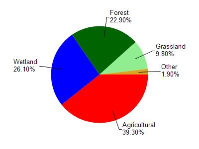
Embarrass River is located in the North Branch and Mainstem Embarrass Rive watershed which is 312.62 mi². Land use in the watershed is primarily agricultural (39.30%), wetland (26.10%) and a mix of forest (22.90%) and other uses (11.70%). This watershed has 488.32 stream miles, 1,175.84 lake acres and 51,339.03 wetland acres.
Nonpoint Source Characteristics
This watershed is ranked High for runoff impacts on streams, High for runoff impacts on lakes and High for runoff impacts on groundwater and therefore has an overall rank of High. This value can be used in ranking the watershed or individual waterbodies for grant funding under state and county programs.However, all waters are affected by diffuse pollutant sources regardless of initial water quality. Applications for specific runoff projects under state or county grant programs may be pursued. For more information, go to surface water program grants.