Price
No
No
No
Fish and Aquatic Life
Overview
Sailor Creek Flowage, in the Upper South Fork Flambeau River Watershed, is a 201.26 acre impoundment that falls in Price County. This impoundment is managed for fishing and swimming and is currently considered impaired.
Date 2011
Author Aquatic Biologist
Historical Description
Source: 1983, Surface Water Resources of Price County,WI: WI-DNR Sailor Creek Flowage - T39N, RIE, Sec. 19, 20, 29, 30.
Sailor Creek Flowage is a soft water, drainage impoundment on Sailor Creek. It has an 8-ft head control structure on the outlet with an estimated flow of 11.5 ft(3)/sec. The flowage is long and irregularly shaped with six wooded islands and several marsh and bog islands. It receives flow not only from Sailor Creek, but also from Coolidge and Hesher Creeks (both trout water entering from the south, and one unnamed minnow stream from Sweeney Lake to the north. The flowage has a fish population of muskellunge, pike, perch, largemouth bass, black crappies, rock bass, pumpkinseeds, black bullheads, white suckers, redhorse and minnows. The flowage shoreline is 75% upland hardwood and pine and the remaining 25% is cattail-tag alder-willow swamp. The littoral bottom is a mixture of sand, gravel, boulders, muck and detritus. Mallards, teal and wood ducks nest here each year, and other ducks and a few geese use the flowage during their spring and fall migrations. Sailor Creek Flowage also has muskrats and beaver. Private development consists of one resort, one boat rental and three cottages or homes. The Town of Fifield owns 0.27 mile of shoreline and provides a public access at the dam site. In addition, there is a platted access on the northeast side and a town road right-of-way access on the extreme
Surface area = 214.6 acres, maximum depth = 8 ft, MPA ppm, Secchi disk = 3 ft.
Date 1983
Author Surface Water Inventory Of Wisconsin
Condition
Wisconsin has over 84,000 miles of streams, 15,000 lakes and milllions of acres of wetlands. Assessing the condition of this vast amount of water is challenging. The state's water monitoring program uses a media-based, cross-program approach to analyze water condition. An updated monitoring strategy (2015-2020) is now available. Compliance with Clean Water Act fishable, swimmable standards are located in the Executive Summary of Water Condition in 2018. See also the 'monitoring and projects' tab.
Reports
Recommendations
Management Goals
Wisconsin's Water Quality Standards provide qualitative and quantitative goals for waters that are protective of Fishable, Swimmable conditions [Learn more]. Waters that do not meet water quality standards are considered impaired and restoration actions are planned and carried out until the water is once again fishable and swimmable
Management goals can include creation or implementation of a Total Maximum Daily Load analysis, a Nine Key Element Plan, or other restoration work, education and outreach and more. If specific recommendations exist for this water, they will be displayed below online.
Monitoring
Monitoring the condition of a river, stream, or lake includes gathering physical, chemical, biological, and habitat data. Comprehensive studies often gather all these parameters in great detail, while lighter assessment events will involve sampling physical, chemical and biological data such as macroinvertebrates. Aquatic macroinvertebrates and fish communities integrate watershed or catchment condition, providing great insight into overall ecosystem health. Chemical and habitat parameters tell researchers more about human induced problems including contaminated runoff, point source dischargers, or habitat issues that foster or limit the potential of aquatic communities to thrive in a given area. Wisconsin's Water Monitoring Strategy was recenty updated.
Grants and Management Projects
Monitoring Projects
| WBIC | Official Waterbody Name | Station ID | Station Name | Earliest Fieldwork Date | Latest Fieldwork Date | View Station | View Data |
|---|
| 2252200 | Sailor Creek Flowage | 10005226 | Sailor Creek Flowage | 8/29/2000 | 9/21/2017 | Map | Data |
| 2252200 | Sailor Creek Flowage | 514013 | Sailor Creek Flowage - West | 7/23/1979 | 10/10/2011 | Map | Data |
| 2252200 | Sailor Creek Flowage | 10019197 | Sailor Creek Flowage -- Access | | | Map | Data |
|
Watershed Characteristics
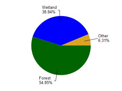
Sailor Creek Flowage is located in the Upper South Fork Flambeau River watershed which is 278.98 mi². Land use in the watershed is primarily forest (54.80%), wetland (38.80%) and a mix of open (4.60%) and other uses (1.70%). This watershed has 254.56 stream miles, 8,509.29 lake acres and 63,099.27 wetland acres.
Nonpoint Source Characteristics
This watershed is ranked Not Ranked for runoff impacts on streams, Low for runoff impacts on lakes and Low for runoff impacts on groundwater and therefore has an overall rank of Low. This value can be used in ranking the watershed or individual waterbodies for grant funding under state and county programs.However, all waters are affected by diffuse pollutant sources regardless of initial water quality. Applications for specific runoff projects under state or county grant programs may be pursued. For more information, go to surface water program grants.