Sheboygan
No
No
No
Fish and Aquatic Life
Overview
BELGIUM CREEK AT RM 17.1
T13N R22E Sec. 22 NWSE Stream Length = 22.2 miles WBIC = 51400
Belgium Creek consist of two major branches, the East Branch that is approximately four miles long and the West Branch is 22 miles. The West Branch is the largest branch consisting of three separate tributaries. The northern-most tributary originates at T13N R22E S31 SWNE and will be referred to as the Grasser Branch of the West Branch for descriptive purposes. The middle branch will be referred to as the Dacada Branch of the West Branch and originates at T13N R22E S32 NWSW. The main branch, of the West Branch of Belgium Creek, will referred to as the Village Branch and originates near the Village of Belgium at T12N R22E S16 SESE. The headwaters of Belgium Creek are primarily in northern Ozaukee County and the stream flows north to a confluence with the Onion River in Sheboygan County. Belgium Creek receives wastewater discharges from the Belgium Wastewater treatment plant and Lakeside Food Co. located on the East Branch of Belgium Creek.
As part of the Sheboygan River Basin monitoring and stream classification review for the East Branch of Belgium Creek; fish, macroinvertebrates, habitat, and, water and sediment chemistry have been collected since 1994. Eleven water chemistry samples were collected between May and October 1994 and analyzed for nutrients, solids and bacteria. These samples were collected as part of the Onion River Bacteriological Study: Assessment of Point and Nonpoint Source Pollution. A bacteriological survey by WDNR in 1990 identified the Onion River downstream of the confluence with Belgium Creek to have appreciably higher fecal coliform bacteria concentrations than upstream (WDNR 1990). In 1994, WDNR sampled two sites on Belgium Creek plus two sites on the Onion River to identify the source(s) of bacteria found in a previous study.
The West Branch of Belgium Creek was identified as the source of the high levels of bacteria to the Onion River (WDNR 1995). The large number of barnyards and pastures along this section of Belgium Creek were most likely the source (Aartila and Galarneau 1998). In contrast, this study found that nutrients, suspended solids and turbidity were higher on the East Branch which are probably from the point source discharges to this branch. Figure 18 depicts the water quality data from the eleven samples collected during 1994 using box-whisker plots showing the maximum and minimum values, median, and the 75th and 25th percentiles. The percentile is the percentage of analyses equal to or less than indicated values with the 50th percentile being the median value.
Nine recent fish surveys have been conducted on the various branches of Belgium Creek. Twelve fish species of fish were collected during the recent fish surveys in the West Branch Belgium Creek and 17 species of fish have been recorded in this branch including earlier fish surveys (Table 55). Recent fish surveys in the East Branch of Belgium Creek observed seven native species and one exotic (carp) (Table 43).
Date 2001
Author Aquatic Biologist
Overview
An Index of Biotic Integrity (Lyons 1992) was calculated for each of the fish collection sites with ratings ranging form 17 (very poor) at the site on the main stem of Belgium Creek to 37 (fair) from the site on the north tributary of the west branch of Belgium Creek (shown in Table 3). These sites were limited from achieving a higher classification due to the high number of tolerant fish, the low number of darter species and lithophylic (riffle) spawning species.
Hilsenhoff Biotic Index samples were collected from the same sites that the chemistry samples were collected in 1994. These sites contained less than optimal HBI sampling substrates due to extensive historical channelization. Since no cobble riffles were present, samples were collected from logs and debris in the stream channel. HBI values recorded from these sites were 7.435 for the West Branch and 7.918 for the East Branch. These values are indicative of fairly poor water quality (West Branch) and poor water quality on the East Branch. Chironomids (39%) and Asellus intermedius (51%) on the West Branch and A. intermedius (74%) on the East Branch dominated the samples.
Sediment samples were collected in 1994 at three sites in the East Branch Belgium Creek to obtain baseline sediment quality data and to assess the potential sediment quality impacts from chromium contaminated groundwater cleanup site in the Village of Belgium. Based on the data results and observations during subsequent field visits of oil sheens in the river, additional sites were sampled in 1997 and 1998. Table 42 shows elevated levels of PAHs, heavy metals, and low levels of PCBs. The full extent of the contaminated sediment in the East Branch of Belgium Creek, its impact on the Onion River, and the source(s) of the contamination are unknown at this time and will require further investigation.
Date 2001
Author Aquatic Biologist
Condition
Wisconsin has over 84,000 miles of streams, 15,000 lakes and milllions of acres of wetlands. Assessing the condition of this vast amount of water is challenging. The state's water monitoring program uses a media-based, cross-program approach to analyze water condition. An updated monitoring strategy (2015-2020) is now available. Compliance with Clean Water Act fishable, swimmable standards are located in the Executive Summary of Water Condition in 2018. See also the 'monitoring and projects' tab.
Reports
Recommendations
Restore Wetlands
Restore Wetlands
Management Goals
Wisconsin's Water Quality Standards provide qualitative and quantitative goals for waters that are protective of Fishable, Swimmable conditions [Learn more]. Waters that do not meet water quality standards are considered impaired and restoration actions are planned and carried out until the water is once again fishable and swimmable
Management goals can include creation or implementation of a Total Maximum Daily Load analysis, a Nine Key Element Plan, or other restoration work, education and outreach and more. If specific recommendations exist for this water, they will be displayed below online.
Monitoring
Monitoring the condition of a river, stream, or lake includes gathering physical, chemical, biological, and habitat data. Comprehensive studies often gather all these parameters in great detail, while lighter assessment events will involve sampling physical, chemical and biological data such as macroinvertebrates. Aquatic macroinvertebrates and fish communities integrate watershed or catchment condition, providing great insight into overall ecosystem health. Chemical and habitat parameters tell researchers more about human induced problems including contaminated runoff, point source dischargers, or habitat issues that foster or limit the potential of aquatic communities to thrive in a given area. Wisconsin's Water Monitoring Strategy was recenty updated.
Grants and Management Projects
Monitoring Projects
| WBIC | Official Waterbody Name | Station ID | Station Name | Earliest Fieldwork Date | Latest Fieldwork Date | View Station | View Data |
|---|
| 51400 | Unnamed | 10049556 | Unnamed Tributary to Onion River at CTH D | 5/25/2018 | 10/18/2018 | Map | Data |
| 51400 | Unnamed | 603238 | Onion River at Cty Hwy D | 9/12/1978 | 9/26/1979 | Map | Data |
| 51400 | Unnamed | 603463 | Un Ditch - Belgium Creek Upstream Of Confluence With Onion River | 6/26/2001 | 6/26/2001 | Map | Data |
|
Watershed Characteristics
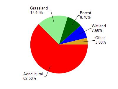
Unnamed is located in the Onion River watershed which is 98.00 mi². Land use in the watershed is primarily agricultural (62.50%), grassland (17.40%) and a mix of forest (8.70%) and other uses (11.40%). This watershed has 132.85 stream miles, 143.10 lake acres and 5,098.92 wetland acres.
Nonpoint Source Characteristics
This watershed is ranked Not Available for runoff impacts on streams, Not Available for runoff impacts on lakes and High for runoff impacts on groundwater and therefore has an overall rank of High. This value can be used in ranking the watershed or individual waterbodies for grant funding under state and county programs.However, all waters are affected by diffuse pollutant sources regardless of initial water quality. Applications for specific runoff projects under state or county grant programs may be pursued. For more information, go to surface water program grants.