Dodge, Fond Du Lac
No
No
Yes
Fish and Aquatic Life
Overview
Kummel Creek (also known as Kiefer Creek) is located in the Upper Rock River Basin of Dodge County near Brownsville, Lomira, and Theresa, Wisconsin. It is 18 miles long and runs southeast into the Rock River near Theresa, WI. Land use in the watershed is primarily agricultural with some residential development. Kummel Creek is west of and in close proximity to the Theresa Marsh Wildlife Area. This stream experiences degraded habitat due to sediment and phosphorus by non-point source runoff from adjacent agricultural fields and point sources (Brownsville wastewater treatment plant and Grande Cheese). Additional problems include sediment and silt deposition in pool areas and channelization of portions of the stream. Water quality monitoring has been conducted between 2004-2006 in preparation for a TMDL report.
Date 2006
Author Aquatic Biologist
Historical Description
Kummel Creek begins just above the village of Brownsville and joins with the East Branch of the Rock River 16 miles downstream at Theresa Marsh. Sediment and silt deposition is severe in pool areas of the stream. Portions of the creek have been channelized. In 2000, the DNR conducted baseline monitoring in the stream. The water quality monitoring, fisheries and habitat assessment data has not been completely evaluated (as of December 2001). Initial evaluation shows the creek to be in fair to poor condition.
Date 2002
Author Aquatic Biologist
Facilities Management
Kummel creek has its headwaters located in the northern part of the Town of Lomira in Dodge County just above the Village of Brownsville. Flowing southeasterly, this small shallow creek enters the East branch of the Rock River near the Village of Theresa.
Sixteen miles long, in an agricultural watershed, this creek receives limited recreational attention. Some of its best potential is within the downstream reaches where depths are greater and fish and wildlife uses increase. These downstream reaches are within a state wildlife refuge.
The uppermost segment between Brownville and County Highway HH is designated
Intermediate fish and aquatic life. The data gathering during 1987 supports this designation. The following narrative will only deal with this segment.
Flows are continuous and USGS has calculated the Q7, 2 at G. 13 CFS and the Q7, 10 at 0.02 CFS. (1) The average flow, based on five measurements between 1972 and 1976 was calculated to be 2.06 CFS (S.D. ? 1.43). Although the variance classification listed in NR 104 indicates Kummel Creek to be non-continuous, it is recommended this be redesignated continuous, based on field observations and USGS data.
Water quality appears to be acceptable at points above the outfalls for Grande Cheese and the Village of Brownsville WWTP's. A HBI sampling on 11/10/87 was assigned a tolerance value of 3.8 which indicates that oxygen values are sufficient to maintain diverse aquatic life. Oxygen levels below the WWTP mixing zones however, may be more depleted. Fish monitoring on 11/25/87 upstream and downstream of the mix zones demonstrated the existence of a tolerant forage fish base consisting primarily of brook stickleback, Culaea
inconstans, with less dense populations of central mudminnows, Umbra limi, and the creek chub, Semotilus atromaculatus. The stickleback and creek chub tolerate silted habitat conditions well and the mudminnow reportedly is capable of tolerating very low oxygen levels. (3) All three species are widely distributed in Wisconsin. Fago, (1982), reported 8 species, all tolerant, within the upper half of Kummel Creek. (5)
A habitat inventory conducted above and below the mixing zone reflects tell tolerant virtues of the forage fish collected. Silt deposition is severe in observe1l reaches when velocity allows particles to settle out. Silt depths
averaged 0.15 meters in runs and pools. Detrital content of the creek substrate was low, indicating soil sources. Velocity in these reaches was <0.1 FPS.
Width averages 2 - 3 meters. Depth is limiting in much of the variance segment. Pool depths are generally less than 2 feet deep and runs are shallow. .Riffles are rare, as only one was observed downstream of STH 49. This is not surprising as the gradient is 4 feet/mile. (B) Instream vegetation and overhead bank vegetation provide the available fish habitat. Very little overhead shading occurs yet stream banks are relatively stable.
Various upstream reaches within the variance segment have been ditched and straightened. These reaches do not provide sufficient habitat. The habitat rating value is 217 (see attached) which indicates poor quality. (2)
Much of this is due to row crop erosion upstream of Brownsville and the past ditching activity. Siltation is severe and runoff related NPS impacts are significant.
There are indications that some point source organic overload may be occurring. Two point sources are at this location. One is from the Brownsville municipal WWTP and the other is from Grande Cheese Company.
During the field investigation, it was unclear which outfall was municipal as the two discharges are located close to each other. Sphaerotilus, filamentous bacteria, was present in the mix zone and indicates a high organic strength discharge. Also, during the field investigation, one of the outfalls was discharging a turbid looking wastewater. In light of these observations it is recommended that these permits be reviewed for compliance with limits.
The upper reaches of Kummel creek on impacted by controllable and uncontrollable factors. Uncontrollable factors include low flows, in stream habitat, urban runoff, and ditching. Controllable factors include cropland and barnyard runoff and the two point sources discussed.
Fish species reflect a tolerant and low diversity fish community. Habitat quality is lacking due to physical stream conditions including shallow depths and low flows. Even with the elimination of controllable factors, the aquatic community here would likely remain unbalanced.
It is, therefore, recommended that Kummel creek, from Brownsville WWTP downstream to CTH "HH" remain classified intermediate fish and aquatic life, use class D, but with a "continuous" hydrologic classification.
Date 1988
Author Paul Laliberte
Impaired Waters
Kiefer (Kummel) Creek, from its mouth to CTH HH (miles 0 to 10.38), was put on the impaired waters list in 1998 for sediment/total suspended solids causing degraded habitat, in 2006 for phosphorus causing low dissolved oxygen and for ammonia causing aquatic toxicity. Phosphorus impairment was confirmed every two-year cycle from 2012 to 2018.
Kiefer (Kummel) Creek, from CTH HH to Brownsville WWTP outfall (miles 10.38 to 11.54), was put on the impaired waters list in 1998 for sediment/total suspended solids causing degraded habitat and in 2006 for phosphorus causing low dissolved oxygen. Phosphorus impairment was confirmed in the 2018 cycle.
Kiefer (Kummel) Creek, from Brownsville WWTP outfall to north of CTH Y (miles 11.54 to 14.0), was put on the impaired waters list in 1998 for sediment/total suspended solids causing degraded habitat and in 2006 for phosphorus causing low dissolved oxygen. Phosphorus assessment in the 2018 cycle showed levels below criteria and this listing was removed.
Kiefer (Kummel) Creek, from north of CTH Y to headwaters (miles 14.0 to 17.96), was put on the impaired waters list in 1998 for sediment/total suspended solids causing degraded habitat and in 2006 for phosphorus causing low dissolved oxygen.
Date 2022
Author Ashley Beranek
Condition
Wisconsin has over 84,000 miles of streams, 15,000 lakes and milllions of acres of wetlands. Assessing the condition of this vast amount of water is challenging. The state's water monitoring program uses a media-based, cross-program approach to analyze water condition. An updated monitoring strategy (2015-2020) is now available. Compliance with Clean Water Act fishable, swimmable standards are located in the Executive Summary of Water Condition in 2018. See also the 'monitoring and projects' tab.
Reports
Management Goals
Wisconsin's Water Quality Standards provide qualitative and quantitative goals for waters that are protective of Fishable, Swimmable conditions [Learn more]. Waters that do not meet water quality standards are considered impaired and restoration actions are planned and carried out until the water is once again fishable and swimmable
Management goals can include creation or implementation of a Total Maximum Daily Load analysis, a Nine Key Element Plan, or other restoration work, education and outreach and more. If specific recommendations exist for this water, they will be displayed below online.
Monitoring
Monitoring the condition of a river, stream, or lake includes gathering physical, chemical, biological, and habitat data. Comprehensive studies often gather all these parameters in great detail, while lighter assessment events will involve sampling physical, chemical and biological data such as macroinvertebrates. Aquatic macroinvertebrates and fish communities integrate watershed or catchment condition, providing great insight into overall ecosystem health. Chemical and habitat parameters tell researchers more about human induced problems including contaminated runoff, point source dischargers, or habitat issues that foster or limit the potential of aquatic communities to thrive in a given area. Wisconsin's Water Monitoring Strategy was recenty updated.
Grants and Management Projects
| Project Name (Click for Details) | Year Started |
|---|
|
|
Monitoring Projects
| WBIC | Official Waterbody Name | Station ID | Station Name | Earliest Fieldwork Date | Latest Fieldwork Date | View Station | View Data |
|---|
| 863500 | Kiefer Creek | 10012855 | Kummel Creek At Hwy 49 | | | Map | Data |
| 863500 | Kiefer Creek | 10032028 | Kummel Creek Brownsville City Park at wastewater plan | 6/8/2002 | 10/24/2004 | Map | Data |
| 863500 | Kiefer Creek | 143337 | Kummel Creek - Hwy 49/Brownsville | 11/10/1987 | 10/11/2016 | Map | Data |
|
Watershed Characteristics
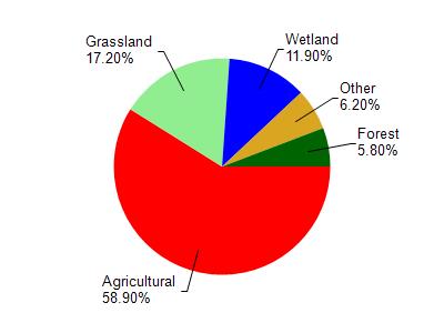
Kiefer Creek is located in the East Branch Rock River watershed which is 198.99 mi². Land use in the watershed is primarily agricultural (58.90%), grassland (17.20%) and a mix of wetland (11.90%) and other uses (12.00%). This watershed has 306.48 stream miles, 292.02 lake acres and 16,059.62 wetland acres.
Nonpoint Source Characteristics
This watershed is ranked High for runoff impacts on streams, High for runoff impacts on lakes and High for runoff impacts on groundwater and therefore has an overall rank of High. This value can be used in ranking the watershed or individual waterbodies for grant funding under state and county programs.However, all waters are affected by diffuse pollutant sources regardless of initial water quality. Applications for specific runoff projects under state or county grant programs may be pursued. For more information, go to surface water program grants.