")
8.26 Miles
7.78 - 16.04
Cool-Cold Mainstem, Cool-Cold Headwater, Coldwater
2021
Good
La Crosse
Yes
Yes
No
Fish and Aquatic Life
Overview
Mouth to Barre Mills (class 3); Barre Mills to CTH M (class 2); CTH M to headwaters (class 1)
Date 2002
Author Aquatic Biologist
Overview
Bostwick Creek, also known as Irish Coulee Creek, is located in central La Crosse County. This stream flows in a northwesterly direction for approximately 13.6 miles, before reaching the La Crosse River. It has a moderate gradient of 38 feet per mile and drains forested hills and agricultural valley land. Bostwick Creek is a Class III trout stream from its mouth upstream to Barre Mills, then Class II upstream to CTH "M", and finally Class I upstream to its headwaters.
A fishery survey conducted in 1965 suggested that Bostwick Creek should not be classified as a trout stream. However, a 1986 fishery survey confirmed natural reproduction of brown trout. The trout population improvement is credited to a combination of consistent stocking and adequate habitat in the upper portions of the stream that allows for natural reproduction and good winter survival. The lower portion of Bostwick Creek contains limited in-stream cover for adult fish. Fishery and habitat surveys should be conducted on Bostwick Creek to determine the current status of the stream. Additional in-stream habitat development in Bostwick Creek would benefit the trout fishery. Bostwick Creek was last stocked in 2001 with wild brown trout. Access to Bostwick Creek is from WDNR owned easements and seven road crossings.
Water chemistry testing of streams throughout La Crosse County was initiated by the La Crosse County Land Conservation Department in 1998. Baseflow conditions were targeted for testing as the most likely to show normal water quality conditions. Sampling takes place four times argeted for testing as the most likely to show normal water quality conditions annually when no rainfall or snowmelt has occurred during the previous 72 hours. Bostwick Creek is sampled at two different locations: near the mouth and approximately six miles upstream from the mouth. Between 1998 and 2001at the middle sampling location, Bostwick Creek met the county phosphorus goal in just over 40% and the county fecal coliform bacteria goal in nearly 50% of the samples taken. At the lower sampling location, Bostwick Creek never met the county phosphorus goal and met the county fecal coliform bacteria goal in only 33% of the samples taken. These data point to a nutrient load that is likely also contributing to high bacterial counts. Data also indicate significant sources of nutrients along the lower six miles of Bostwick Creek. The county ranks Bostwick Creek in the top 50% of county streams on which to expend effort to reduce phosphorus and bacterial contamination. La Crosse County should continue baseflow sampling of Bostwick Creek to determine water quality trends.
Date 2002
Author Aquatic Biologist
Impaired Waters
Bostwick Creek, from its mouth to Barre Mills (miles 0 to 3.65), was evaluated for phosphorus and biology every two years between 2014 and 2020. Phosphorus levels were found to be too high.
Bostwick Creek, from Barre Mills to CTH M (miles 3.65 to 7.78), was evaluated in the 2018 cycle for biology and communities were in good condition. This segment is on the Healthy Waters List.
Bostwick Creek, from CTH M to its headwaters (miles 7.78 to 16.04), was evaluated in the 2018 cycle for biology and communities were in good condition. This segment is on the Healthy Waters List.
Date 2020
Author Ashley Beranek
Condition
Wisconsin has over 84,000 miles of streams, 15,000 lakes and milllions of acres of wetlands. Assessing the condition of this vast amount of water is challenging. The state's water monitoring program uses a media-based, cross-program approach to analyze water condition. An updated monitoring strategy (2015-2020) is now available. Compliance with Clean Water Act fishable, swimmable standards are located in the Executive Summary of Water Condition in 2018. See also the 'monitoring and projects' tab.
Reports
Management Goals
Wisconsin's Water Quality Standards provide qualitative and quantitative goals for waters that are protective of Fishable, Swimmable conditions [Learn more]. Waters that do not meet water quality standards are considered impaired and restoration actions are planned and carried out until the water is once again fishable and swimmable
Management goals can include creation or implementation of a Total Maximum Daily Load analysis, a Nine Key Element Plan, or other restoration work, education and outreach and more. If specific recommendations exist for this water, they will be displayed below online.
Monitoring
Monitoring the condition of a river, stream, or lake includes gathering physical, chemical, biological, and habitat data. Comprehensive studies often gather all these parameters in great detail, while lighter assessment events will involve sampling physical, chemical and biological data such as macroinvertebrates. Aquatic macroinvertebrates and fish communities integrate watershed or catchment condition, providing great insight into overall ecosystem health. Chemical and habitat parameters tell researchers more about human induced problems including contaminated runoff, point source dischargers, or habitat issues that foster or limit the potential of aquatic communities to thrive in a given area. Wisconsin's Water Monitoring Strategy was recenty updated.
Grants and Management Projects
Monitoring Projects
| WBIC | Official Waterbody Name | Station ID | Station Name | Earliest Fieldwork Date | Latest Fieldwork Date | View Station | View Data |
|---|
| 1650900 | Bostwick Creek | 10013257 | Bostwick Creek St. 3 - Bridge On Larson Road | | | Map | Data |
| 1650900 | Bostwick Creek | 10009119 | Bostwick Creek #7- Field Rd. Crossing On Tremaine Property | 10/31/2018 | 10/31/2018 | Map | Data |
| 1650900 | Bostwick Creek | 10009117 | Bostwick Creek #5- 300 Meters Downstream From Cty Ii Bridge | 10/25/2018 | 10/25/2018 | Map | Data |
| 1650900 | Bostwick Creek | 10013916 | Bostwick Creek Station 9 - Farm Road Crossing | | | Map | Data |
| 1650900 | Bostwick Creek | 323018 | Bostwick Creek - Tn Rd Bl Newburg Cr | | | Map | Data |
| 1650900 | Bostwick Creek | 10013915 | Bostwick Creek Station 7 - Farm Road Bridge Crossing | 1/1/2015 | 1/1/2015 | Map | Data |
| 1650900 | Bostwick Creek | 10013256 | Bostwick Creek St. 1 - Bridge On Drogseth Road | 1/1/2015 | 1/1/2015 | Map | Data |
| 1650900 | Bostwick Creek | 10013914 | Bostwick Creek Station 6 - Cth Ii Bridge | 10/23/2001 | 1/1/2015 | Map | Data |
| 1650900 | Bostwick Creek | 10009116 | Bostwick Creek #4- Bridge On Cty M | 1/1/2015 | 10/25/2021 | Map | Data |
| 1650900 | Bostwick Creek | 10009118 | Bostwick Creek #6- Lower Field Rd. Crossing On Schomberg Farm | 7/25/2018 | 10/25/2018 | Map | Data |
| 1650900 | Bostwick Creek | 10013917 | Bostwick Creek Station 6 - Farm Road Crossing | | | Map | Data |
|
Watershed Characteristics
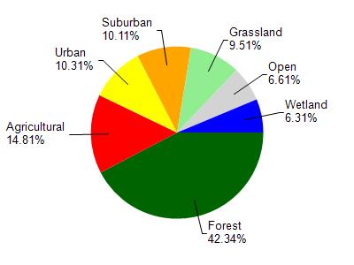
Bostwick Creek is located in the Lower La Crosse River watershed which is 145.46 mi². Land use in the watershed is primarily forest (42.30%), agricultural (14.80%) and a mix of urban (10.30%) and other uses (32.50%). This watershed has 295.20 stream miles, 1,187.12 lake acres and 5,641.64 wetland acres.
Nonpoint Source Characteristics
This watershed is ranked Medium for runoff impacts on streams, Not Ranked for runoff impacts on lakes and Low for runoff impacts on groundwater and therefore has an overall rank of Low. This value can be used in ranking the watershed or individual waterbodies for grant funding under state and county programs.However, all waters are affected by diffuse pollutant sources regardless of initial water quality. Applications for specific runoff projects under state or county grant programs may be pursued. For more information, go to surface water program grants.
Bostwick Creek is considered a Cool-Cold Mainstem, Cool-Cold Headwater, Coldwater under the state's Natural Community Determinations.
Natural communities (stream and lake natural communities) represent model results and DNR staff valiation processes that confirm or update predicted conditions based on flow and temperature modeling from historic and current landscape features and related variables. Predicated flow and temperatures for waters are associated predicated fish assemblages (communities). Biologists evaluate the model results against current survey data to determine if the modeled results are corect and whether biological indicators show water quaity degradation. This analysis is a core component of the state's resource management framework. Wisconsin's Riverine Natural Communities.
Cool (Cold-Transition) Mainstem streams are moderate-to-large but still wadeable perennial streams with cold to cool summer temperatures. Coldwater fishes are common to uncommon, transitional fishes are abundant to common, and warm water fishes are uncommon to absent. Headwater species are common to absent,
mainstem species are abundant to common, and river species are common to absent.
Cool (Cold-Transition) Headwaters are small, usually perennial streams with cold to cool summer temperatures. Coldwater fishes are common to uncommon (<10 per 100 m), transitional fishes are abundant to common, and warm water fishes are uncommon to absent. Headwater species are abundant to common, mainstem species are common to absent, and river species are absent.
No change for first 6.2 miles, David Vetrano, October 2003, 608 785-9009, then: "Recent surveys show the lower 3.2 miles of Bostwick Creek may have some natural reproduction but not enough to utilize available food and space. Therefore, stocking sometimes is required to maintain a desireable sport fishery. This portion of stream shows good survival and carryover of adult trout often producing some fish of better than average size...(upper portion). Barre Mill downstream to LaCross River changed from a Class III to a Class II in 2008.
Date 2008
Author Aquatic Biologist