Hingham Millpond, Onion River Watershed (SH04)
Hingham Millpond (52200)
38.50 Acres
Natural Community
Natural communities (stream and lake natural communities) represent model results that use predicted flow and temperature based on landscape features and related assumptions. Ranges of flow and temperature associated with specific aquatic life communities (fish, macroinvertebrates) help biologists identify appropriate resource management goals. Wisconsin Natural Communities.
Impounded Flowing Water
Year Last Monitored
This is the most recent date of monitoring data stored in SWIMS. Additional surveys for fish and habitat may be available subsequent to this date.
2017
Fair
 
Sheboygan
Trout Water 
Trout Waters are represented by Class I, Class II or Class III waters. These classes have specific ecological characteristics and management actions associated with them. For more information regarding Trout Classifications, see the Fisheries Trout Class Webpages.
No
Outstanding or Exceptional 
Wisconsin has designated many of the state's highest quality waters as Outstanding Resource Waters (ORWs) or Exceptional Resource Waters (ERWs). Waters designated as ORW or ERW are surface waters which provide outstanding recreational opportunities, support valuable fisheries and wildlife habitat, have good water quality, and are not significantly impacted by human activities. ORW and ERW status identifies waters that the State of Wisconsin has determined warrant additional protection from the effects of pollution. These designations are intended to meet federal Clean Water Act obligations requiring Wisconsin to adopt an 'antidegradation' policy that is designed to prevent any lowering of water quality - especially in those waters having significant ecological or cultural value.
No
Impaired Water 
A water is polluted or 'impaired' if it does not support full use by humans, wildlife, fish and other aquatic life and it is shown that one or more of the pollutant criteria are not met.
No

Fish and Aquatic Life

Current Use
The use the water currently supports. This is not a designation or classification; it is based on the current condition of the water. Information in this column is not designed for, and should not be used for, regulatory purposes.
Impounded Flowing Water
This classification includes waterbodies created by dams (mill ponds, reservoirs, flowages, and other impoundments) with a residence time of 14 days or more (under summer (June – Sept) mean low flow conditions with a 1 in 10 year recurrence interval (US EPA 2000)). Many natural lakes also have dams or water level control structures. However, to be included in the Impounded Flowing Waters category, the dam or water level control structure, must account for more than half of a waterbody’s maximum depth. Impoundments with a residence time of less than 14 days should be covered under the rivers and stream assessment methodology process.
Attainable Use
The use that the investigator believes the water could achieve through managing "controllable" sources. Beaver dams, hydroelectric dams, low gradient streams, and naturally occurring low flows are generally not considered controllable. The attainable use may be the same as the current use or it may be higher.
Default FAL
Fish and Aquatic Life - Default Waters do not have a specific use designation subcategory but are considered fishable, swimmable waters.
Designated Use
This is the water classification legally recognized by NR102 and NR104, Wis. Adm. Code. The classification determines water quality criteria and effluent limits. Waters obtain designated uses through classification procedures.
Default FAL
Fish and Aquatic Life - Default Waters do not have a specific use designation subcategory but are considered fishable, swimmable waters.

Overview

ONION RIVER HINGHAM MILLPOND AT RM 28.3
T14N R22E Sec. 31 Surface Acres = 38 Maximum Depth = 6 ft.

This is the downstream-most dam on the Onion River and has a sill height of six feet. The dam is located on the north side of Hingham just upstream of CTH I. The condition of the dam is undergoing an evaluation by WDNR dam safety personnel. No recent water quality information has been collected on the Hingham impoundment.

A sediment quality assessment was conducted by WDNR on June 29, 1999 on the Hingham Impoundment, Onion River (Table 36). Three sample sites were sampled in the soft sediment that has accumulated behind the dam. Samples were collected 30, 45 and 60 meters upstream from the dam.

Date  2001

Author   Aquatic Biologist

Historical Description

Source: 1968, Surface Water Resources of Sheboygan County Hingham Millpond T14N, R22E, Section 30, 31 Surface Acres = 38, S.D.F. = 2.66, Maximum Depth = 6 feet The southernmost of two flowages on the west branch of the Onion River. The impoundment is created by a dam with a head of six feet. The bottom consists primarily of gravel and muck with some sand. Extreme shallowness, turbidity, and periodic algae blooms are major use problems. Some northern pike are present. However, to what degree these species are found within the flowage proper is relatively unknown. Fair numbers of migrating puddle ducks benefit from the back water provided. Hunting is permitted, and one town, public access with parking is available.

Date  1968

Author   Surface Water Inventory Of Wisconsin

Hingham Millpond, Onion River Watershed (SH04) Fish and Aquatic LifeHingham Millpond, Onion River Watershed (SH04) RecreationHingham Millpond, Onion River Watershed (SH04) Fish Consumption

Condition

Wisconsin has over 84,000 miles of streams, 15,000 lakes and milllions of acres of wetlands. Assessing the condition of this vast amount of water is challenging. The state's water monitoring program uses a media-based, cross-program approach to analyze water condition. An updated monitoring strategy (2015-2020) is now available. Compliance with Clean Water Act fishable, swimmable standards are located in the Executive Summary of Water Condition in 2018. See also the 'monitoring and projects' tab.

Reports

Management Goals

Wisconsin's Water Quality Standards provide qualitative and quantitative goals for waters that are protective of Fishable, Swimmable conditions [Learn more]. Waters that do not meet water quality standards are considered impaired and restoration actions are planned and carried out until the water is once again fishable and swimmable

Management goals can include creation or implementation of a Total Maximum Daily Load analysis, a Nine Key Element Plan, or other restoration work, education and outreach and more. If specific recommendations exist for this water, they will be displayed below online.

Monitoring

Monitoring the condition of a river, stream, or lake includes gathering physical, chemical, biological, and habitat data. Comprehensive studies often gather all these parameters in great detail, while lighter assessment events will involve sampling physical, chemical and biological data such as macroinvertebrates. Aquatic macroinvertebrates and fish communities integrate watershed or catchment condition, providing great insight into overall ecosystem health. Chemical and habitat parameters tell researchers more about human induced problems including contaminated runoff, point source dischargers, or habitat issues that foster or limit the potential of aquatic communities to thrive in a given area. Wisconsin's Water Monitoring Strategy was recenty updated.

Grants and Management Projects

Monitoring Projects

Watershed Characteristics

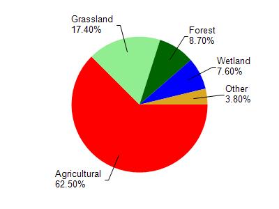
Hingham Mill Pond is located in the Onion River watershed which is 98.00 mi². Land use in the watershed is primarily agricultural (62.50%), grassland (17.40%) and a mix of forest (8.70%) and other uses (11.40%). This watershed has 132.85 stream miles, 143.10 lake acres and 5,098.92 wetland acres.

Nonpoint Source Characteristics

This watershed is ranked Not Available for runoff impacts on streams, Not Available for runoff impacts on lakes and High for runoff impacts on groundwater and therefore has an overall rank of High. This value can be used in ranking the watershed or individual waterbodies for grant funding under state and county programs.However, all waters are affected by diffuse pollutant sources regardless of initial water quality. Applications for specific runoff projects under state or county grant programs may be pursued. For more information, go to surface water program grants.

Natural Community

Hingham Millpond is considered a Impounded Flowing Water under the state's Natural Community Determinations.

Natural communities (stream and lake natural communities) represent model results and DNR staff valiation processes that confirm or update predicted conditions based on flow and temperature modeling from historic and current landscape features and related variables. Predicated flow and temperatures for waters are associated predicated fish assemblages (communities). Biologists evaluate the model results against current survey data to determine if the modeled results are corect and whether biological indicators show water quaity degradation. This analysis is a core component of the state's resource management framework. Wisconsin's Riverine Natural Communities.

This classification includes waterbodies created by dams (mill ponds, reservoirs, flowages, and other impoundments) with a residence time of 14 days or more (under summer (June – Sept) mean low flow conditions with a 1 in 10 year recurrence interval (US EPA 2000)). Many natural lakes also have dams or water level control structures. However, to be included in the Impounded Flowing Waters category, the dam or water level control structure, must account for more than half of a waterbody’s maximum depth. Impoundments with a residence time of less than 14 days should be covered under the rivers and stream assessment methodology process.

More Interactive Maps