Sheboygan
No
No
No
Fish and Aquatic Life
Overview
ONION RIVER WALDO MILLPOND AT RM 31.9
T14N R21E Sec. 14 Surface Acres = 40 Maximum Depth = 7 ft.
The Waldo millpond is located at Waldo just east of STH 57 and is created by a dam with an 8 1/2 foot high sill. As part of a study conducted in 1994, the Waldo millpond was used to assess the impacts associated with impoundments on river systems (Aartila, 1995). The Onion River from its headwaters to the Waldo Impoundment is classified as cold water community stream and as a warm water sport fish community downstream of the impoundment.
The effects of slower current velocities and no stream side shading resulted in dramatic increases in the maximum air temperature and water temperature recorded from both the Waldo millpond and STH 57 (which is just downstream of the Waldo millpond) sites. In comparison, the shady upstream site at CTH E displayed much cooler air and water temperatures (Aartila 1995). During August of 1994, the maximum daily air temperature at the shady site was approximately 5oC cooler than the downstream sites. Likewise maximum water temperatures were also much cooler at CTH E than the Waldo millpond and STH 57 sites by approximately 5oC. Streamside shading on the Onion River reduces the warming effect of direct sunlight on the water surfaces at these shaded sites and reduces maximum air temperatures.
Not only does the Waldo millpond slow current velocities and expose surface waters to direct sunlight, it also increases algae productivity and provides optimal habitat for bottom feeding fishes (e.g. carp). Increases in algae concentrations (statistically significantly different at p<0.05, n=12) and increases in suspended solid concentrations (although not statistically significant) through bioturbation are both real threats to water quality downstream of the millpond (Aartila 1995). Increases in the geometric mean concentration of chlorophyll a (3.4 g/l to 27.2 g/l) and suspended solids (10 mg/l to 31 mg/l) upstream and below the Waldo millpond document these effects. Samples collected for the study from the Mullet River provide a point of reference for a typical free-flowing river system and are reported on in the Mullet River Watershed section (and fully in the Aartila 1995 report).
Date 2001
Author Aquatic Biologist
Historical Description
Source: 1968, Surface Water Resources of Sheboygan County Waldo Millpond T14N, R2 1E, Section 14 Surface Acres -- 40, S.D.F. = 2.70, Maximum Depth = 7 feet A moderate-sized flowage on the Onion River created by a dam with an 8-1/2 foot high sill. Northern pike and panfish constitute the main sport fishery. The Onion River is trout water to the flowage--a few trout are caught during the early part of trout season. Carp, turbidity, and fluctuating water levels are major use problems. The impoundment experienced a partial fish kill in September, 19611--primarily northern pike. The kill was attributed to an oxygen depletion caused by a combination of naturally high fertility and extremely hot weather. The area has value for fair numbers of nesting and migrating puddle ducks in the spring and fall. No public access is available, and hunting is allowed only by permission.
Date 1968
Author Surface Water Inventory Of Wisconsin
Condition
Wisconsin has over 84,000 miles of streams, 15,000 lakes and milllions of acres of wetlands. Assessing the condition of this vast amount of water is challenging. The state's water monitoring program uses a media-based, cross-program approach to analyze water condition. An updated monitoring strategy (2015-2020) is now available. Compliance with Clean Water Act fishable, swimmable standards are located in the Executive Summary of Water Condition in 2018. See also the 'monitoring and projects' tab.
Reports
Management Goals
Wisconsin's Water Quality Standards provide qualitative and quantitative goals for waters that are protective of Fishable, Swimmable conditions [Learn more]. Waters that do not meet water quality standards are considered impaired and restoration actions are planned and carried out until the water is once again fishable and swimmable
Management goals can include creation or implementation of a Total Maximum Daily Load analysis, a Nine Key Element Plan, or other restoration work, education and outreach and more. If specific recommendations exist for this water, they will be displayed below online.
Monitoring
Monitoring the condition of a river, stream, or lake includes gathering physical, chemical, biological, and habitat data. Comprehensive studies often gather all these parameters in great detail, while lighter assessment events will involve sampling physical, chemical and biological data such as macroinvertebrates. Aquatic macroinvertebrates and fish communities integrate watershed or catchment condition, providing great insight into overall ecosystem health. Chemical and habitat parameters tell researchers more about human induced problems including contaminated runoff, point source dischargers, or habitat issues that foster or limit the potential of aquatic communities to thrive in a given area. Wisconsin's Water Monitoring Strategy was recenty updated.
Grants and Management Projects
| Project Name (Click for Details) | Year Started |
|---|
|
|
Monitoring Projects
| WBIC | Official Waterbody Name | Station ID | Station Name | Earliest Fieldwork Date | Latest Fieldwork Date | View Station | View Data |
|---|
| 52500 | Waldo Mill Pond | 603039 | Onion River - Larson Co. (Waldo) - Lagoons | 7/8/1976 | 9/23/1985 | Map | Data |
| 52500 | Waldo Mill Pond | 10005802 | Waldo Mill Pond | 9/8/2000 | 8/30/2017 | Map | Data |
| 52500 | Waldo Mill Pond | 605021 | Onion River - Below Waldo | | | Map | Data |
|
Watershed Characteristics
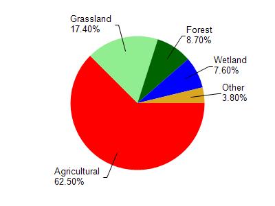
Waldo Mill Pond is located in the Onion River watershed which is 98.00 mi². Land use in the watershed is primarily agricultural (62.50%), grassland (17.40%) and a mix of forest (8.70%) and other uses (11.40%). This watershed has 132.85 stream miles, 143.10 lake acres and 5,098.92 wetland acres.
Nonpoint Source Characteristics
This watershed is ranked Not Available for runoff impacts on streams, Not Available for runoff impacts on lakes and High for runoff impacts on groundwater and therefore has an overall rank of High. This value can be used in ranking the watershed or individual waterbodies for grant funding under state and county programs.However, all waters are affected by diffuse pollutant sources regardless of initial water quality. Applications for specific runoff projects under state or county grant programs may be pursued. For more information, go to surface water program grants.