Outagamie
No
No
No
Fish and Aquatic Life
Overview
Duck Creek is a 42-mile hard water stream that originates in Burma Swamp, located in central Outagamie County, and winds northeast until it empties into the bay of Green Bay, just north of the city of Green Bay. The drainage area of the Duck Creek Watershed encompasses 152 square miles with land use in the upper portion being primarily agricultural and the lower portion being predominantly residential and urban. A Fisheries and Habitat Evaluation Assessment Plan (FHEAP) was designed for Duck Creek by the U.S. Fish and Wildlife Service, WDNR and the Oneida Tribe of Indians. This project provided information on the habitat and fish community of the Duck Creek Watershed. Sampling included fish collection and identification, population estimates and habitat evaluations. A final report will be available sometime this year (1998). The resident fishery consists primarily of panfish, bullheads and northern pike while seasonal runs of salmon, yellow perch, northern pike, walleye and suckers occur. A species of special concern, the redside dace, is present in a portion of Duck Creek. Most of Duck Creek is classified as a warm water sport fishery with the exception of the upper reaches which are classified as warm water forage fishery. Duck Creek is impacted by a multitude of negative landuse practices: Streambank buffers are rare, livestock and cropping occur right up to the streambank and ditching is prevalent. The result is erosion causing turbid water, warmer water temperatures, lower dissolved oxygen levels, stream flashiness and dramatic water fluctuation including periods of ponding and no flow (Johnson 1996 & 1998). The Water Resources Division of the U.S. Geological Survey, in cooperation with local, State and Federal agencies, obtains a large amount of data pertaining to the water resources of Wisconsin each year (Holmstrom 1995). A gauging station is located on Duck Creek on the right bank upstream from the HWY FF Road bridge, near Howard. The station has been in service since April 1988. The type of data being collected include: chemical, discharge, sediment, and water temperature. Please refer to the U.S. Geological Survey Water Resource Data Wisconsin Water Year 1996 for specific data. The USGS also has a National Water Quality Assessment (NAWQA) station located on Duck Creek at Seminary Road. This station began collecting samples in March 1993. Parameters which were collected include: pesticides, macroinvertebrates, sediments, algae, habitat evaluations were conducted, caddisfly and fish tissue analysis was performed and vegetation plot surveys were completed (Johnson 1996).
Bougie, Cheryl A. 1999. Lower Fox River Basin Water Quality Management Plan. Public Review Draft. Wisconsin Department of Natural Resources, Madison, WI.
Date 1999
Author Cheryl Bougie
Historical Description
Duck Creek, T23N, R19E, Sec. 4(6), Area = 54.1 acres, Length = 22.3 miles, M.P.A. = 242 ppm,
Gradient = 4.5 feet/mile.
Duck Creek is a hard water, turbid stream moving sluggishly through east central Outagamie County into
Brown County and Green Bay. Silt is the predominant bottom material. Areas of sand, gravel, and rubble are
also present. Instream cover is light, consisting of undercut banks, rocks, logs, and debris. Bottom
organisms are scarce; crayfish and caddisflies are present. Upland areas consist primarily of hardwoods
and agricultural fields. Public access is limited to road crossings of which there are one state, six county,
and seven town. Wildlife values are somewhat limited by the agricultural uses of this area.
From: Nelson, Linden M. and Ronald L. Fassbender, 1972. Surface Water Resources of Outagamie County:
Lake and Stream Classification Project. Wisconsin Department of Natural Resources, Madison, WI.
Date 1972
Author Surface Water Inventory Of Wisconsin
Impaired Waters
The 2018 assessments of Duck Creek (miles 25.69-32.9) showed continued impairment by phosphorus; new total phosphorus sample data overwhelmingly exceeded the 2018 WisCALM listing criteria for the Fish and Aquatic Life use. Available biological data did not indicate impairment (i.e. no macroinvertebrate or fish Index of Biotic Integrity (IBI) scored in the "poor" condition category). Based on the most updated information, no change in the existing impaired waters listing was needed.
Date 2017
Author Ashley Beranek
Impaired Waters
The 2018 assessments of Duck Creek (miles 0-4.96) showed continued impairment by phosphorus; new total phosphorus sample data exceeded the 2018 WisCALM listing criteria for the Fish and Aquatic Life use. Available biological data did not indicate impairment (i.e. no macroinvertebrate or fish Index of Biotic Integrity (IBI) scored in the "poor" condition category). Based on the most updated information, no change in the existing impaired waters listing was needed.
Date 2017
Author Ashley Beranek
Impaired Waters
Duck Creek (409700), from its mouth to the border of Oneida Tribal Land, was placed on the impaired waters list for sediment/total suspended solids in 1998, for mercury in fish tissue in 2002, and for total phosphorus in 2008. The TMDL for sediment/total suspended solids and total phosphorus was approved by the U.S. EPA in 2012. The 2016 assessments showed continued impairment by phosphorus; total phosphorus sample data exceed 2016 WisCALM listing criteria for the Fish and Aquatic Life use, however, no biological data (i.e. no macroinvertebrate or fish Index of Biotic Integrity (IBI) scores) were available to assess biological impairment. Based on the most updated information, no change in existing impaired waters listing is needed.
Date 2015
Author Aaron Larson
Impaired Waters
Duck Creek (409700), from the west border of Oneida Tribal Land to French Road, was placed on the impaired waters list for mercury in fish tissue and for total phosphorus in 1998, and for sediment/total suspended solids in 2008. The TMDL for sediment/total suspended solids and total phosphorus was approved by the U.S. EPA in 2012.
Date 2015
Author Aaron Larson
Condition
Wisconsin has over 84,000 miles of streams, 15,000 lakes and milllions of acres of wetlands. Assessing the condition of this vast amount of water is challenging. The state's water monitoring program uses a media-based, cross-program approach to analyze water condition. An updated monitoring strategy (2015-2020) is now available. Compliance with Clean Water Act fishable, swimmable standards are located in the Executive Summary of Water Condition in 2018. See also the 'monitoring and projects' tab.
Reports
Recommendations
Monitor Water Quality or Sediment
Only assessment result is "poor". Further monitoring recommended. AU: 3884932; Station ID: 10015591
Navigability Determination
SE SW S7 T22N R18E; Duck Creek, trib;
Navigability Determination
SE SW S7 T22N R18E; Duck Creek, trib;
Navigability Determination
SE SW S7 T22N R18E; Duck Creek, trib;
Navigability Determination
S26 T24N R19E; Trout Creek, trib;
Monitor Targeted Watershed Area (TWA)
Apple-Duck-Ashwaubenon-West Plum (319 Project, SP12/WQ10) [HUC12] TWA
Watershed Mapping or Assessment
The main objective of this project is to identify hard structural BMP's that were installed under the Priority Watershed Plan or the GLRI grant and evaluate their influence on improving water quality conditions within the watersheds.
AWQMP Cooperative Agreement
BCPC 2017 WQM Planning contract.
Nine Key Element Plan
Upper Duck Creek PWS Plan - Nine Key Element Plan - The Upper Duck Creek Watershed is a subwatershed of the Lower Fox River Basin and is located in east central Wisconsin in Outagamie County. Duck Creek starts in the Town of Black Creek, flows through the Town of Center, Osborn, Freedom, and Oneida before flowing into the Bay of Green Bay in Hobart. Excessive sediment loads and increased algal blooms in the Lower Fox River and Bay of Green Bay prompted the need for action to be taken in the Lower Fox River Basin. A Total Maximum Daily Load was approved for the Lower Fox River and Lower Green Bay and its tributaries in 2012. The development of implementation plans for the subwatersheds of the Lower Fox River Basin are necessary to meet the assigned daily loads of the TMDL.
Monitor Fish Tissue
409700 name Duck Creek TMDL ID 116 Start Mile 0 End Mile 4.96
Monitor Fish Tissue
409700 name Duck Creek TMDL ID 117 Start Mile 25.69 End Mile 32.9
Management Goals
Wisconsin's Water Quality Standards provide qualitative and quantitative goals for waters that are protective of Fishable, Swimmable conditions [Learn more]. Waters that do not meet water quality standards are considered impaired and restoration actions are planned and carried out until the water is once again fishable and swimmable
Management goals can include creation or implementation of a Total Maximum Daily Load analysis, a Nine Key Element Plan, or other restoration work, education and outreach and more. If specific recommendations exist for this water, they will be displayed below online.
Monitoring
Monitoring the condition of a river, stream, or lake includes gathering physical, chemical, biological, and habitat data. Comprehensive studies often gather all these parameters in great detail, while lighter assessment events will involve sampling physical, chemical and biological data such as macroinvertebrates. Aquatic macroinvertebrates and fish communities integrate watershed or catchment condition, providing great insight into overall ecosystem health. Chemical and habitat parameters tell researchers more about human induced problems including contaminated runoff, point source dischargers, or habitat issues that foster or limit the potential of aquatic communities to thrive in a given area. Wisconsin's Water Monitoring Strategy was recenty updated.
Grants and Management Projects
Monitoring Projects
| WBIC | Official Waterbody Name | Station ID | Station Name | Earliest Fieldwork Date | Latest Fieldwork Date | View Station | View Data |
|---|
| 409700 | Duck Creek | 10015591 | Duck Creek-Upstream Of Cty Ee | 1/1/2015 | 9/22/2015 | Map | Data |
| 409700 | Duck Creek | 10039206 | Duck Creek-Stingle Rd | 5/11/2013 | 5/11/2013 | Map | Data |
| 409700 | Duck Creek | 10044062 | Duck Creek 20 Meters US Krueger Road | 1/1/2015 | 9/22/2015 | Map | Data |
|
Watershed Characteristics
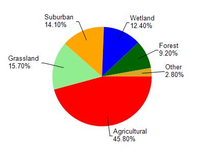
Duck Creek is located in the Duck Creek watershed which is 151.61 mi². Land use in the watershed is primarily agricultural (45.80%), grassland (15.70%) and a mix of suburban (14.10%) and other uses (24.40%). This watershed has 302.11 stream miles, 2,064.01 lake acres and 8,189.35 wetland acres.
Nonpoint Source Characteristics
This watershed is ranked High for runoff impacts on streams, Not Available for runoff impacts on lakes and High for runoff impacts on groundwater and therefore has an overall rank of High. This value can be used in ranking the watershed or individual waterbodies for grant funding under state and county programs.However, all waters are affected by diffuse pollutant sources regardless of initial water quality. Applications for specific runoff projects under state or county grant programs may be pursued. For more information, go to surface water program grants.