St. Croix
No
No
Yes
Fish and Aquatic Life
Overview
The New Richmond Flowage suffers from excessive nutrients, and is a shallow weed infested waterbody. Most of the flowage is 5 feet deep and is plagued with fine sediment deposition. The fine sediment obviously comes from the headwater region of the watershed. The 236 acre flowage shifts the thermal regime toward warmwater until groundwater becomes more
prevalent downstream within Willow River State Park.
Date 2010
Author Kathy Bartilson
Historical Description
A hardwater, drainage impoundment situated on the Willow River. It has a navigable inlet and a 16 foot head private power dam (New Richmond Roller Mills) on its outlet (32 CFS). Managed for largemouth bass and panfish that include bluegills, perch, black crappies, pumpkinseeds and black bullheads. Northern pike and brook trout are also present. Excessive weed growth makes angling and boating difficult here. Other than the navigable access from the Willow River, this flowage has no boat landings, except a private one at the west end. The owner here charges a parking fee and only fishing boats are allowed to launch here. A city park of about 12 acres and 2,300 feet of frontage is located on the south shore. A swimming pool is available to the public at the park. Unsuitable water conditions render the flowage unfavorable for swimming. There is one boat livery and 20 dwellings on the flowage. Muskrats -and nesting mallards, blue-winged teal, wood ducks and hooded mergansers utilize the 10,acres of wild rice wetlands near the inlet. Coots and other ducks of the puddle and divers groups also use the flowage to a great extent during the migratory seasons.
Source: 1961, Surface Water Resources of St.Croix Co. New Richmond Flowage - T. 31 N., R. 17, 18 W., Sec. 31, 36 Surface Acres = 142. 0 S. D. F. - 3. 11 Maximum Depth = 12 feet
Date 1961
Author Surface Water Inventory Of Wisconsin
Condition
Wisconsin has over 84,000 miles of streams, 15,000 lakes and milllions of acres of wetlands. Assessing the condition of this vast amount of water is challenging. The state's water monitoring program uses a media-based, cross-program approach to analyze water condition. An updated monitoring strategy (2015-2020) is now available. Compliance with Clean Water Act fishable, swimmable standards are located in the Executive Summary of Water Condition in 2018. See also the 'monitoring and projects' tab.
Reports
Recommendations
Monitor Water Quality or Sediment
Highly variable results over five year period. Will revisit in 2020 when there is more data. AU: 3894231; Station ID: 10017346
Management Goals
Wisconsin's Water Quality Standards provide qualitative and quantitative goals for waters that are protective of Fishable, Swimmable conditions [Learn more]. Waters that do not meet water quality standards are considered impaired and restoration actions are planned and carried out until the water is once again fishable and swimmable
Management goals can include creation or implementation of a Total Maximum Daily Load analysis, a Nine Key Element Plan, or other restoration work, education and outreach and more. If specific recommendations exist for this water, they will be displayed below online.
Monitoring
Monitoring the condition of a river, stream, or lake includes gathering physical, chemical, biological, and habitat data. Comprehensive studies often gather all these parameters in great detail, while lighter assessment events will involve sampling physical, chemical and biological data such as macroinvertebrates. Aquatic macroinvertebrates and fish communities integrate watershed or catchment condition, providing great insight into overall ecosystem health. Chemical and habitat parameters tell researchers more about human induced problems including contaminated runoff, point source dischargers, or habitat issues that foster or limit the potential of aquatic communities to thrive in a given area. Wisconsin's Water Monitoring Strategy was recenty updated.
Grants and Management Projects
Monitoring Projects
| WBIC | Official Waterbody Name | Station ID | Station Name | Earliest Fieldwork Date | Latest Fieldwork Date | View Station | View Data |
|---|
| 2608800 | New Richmond Flowage | 10005434 | New Richmond Flowage | 8/7/2001 | 10/3/2016 | Map | Data |
| 2608800 | New Richmond Flowage | 563129 | New Richmond Flowage - Deep Hole | 4/22/2003 | 8/14/2003 | Map | Data |
| 2608800 | New Richmond Flowage | 10017346 | New Richmond Flowage - Mary Park Beach | 5/21/2007 | 8/9/2025 | Map | Data |
|
Watershed Characteristics
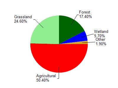
New Richmond Flowage is located in the Upper Willow River watershed which is 183.67 mi². Land use in the watershed is primarily agricultural (50.40%), grassland (24.60%) and a mix of forest (17.40%) and other uses (7.60%). This watershed has 319.19 stream miles, 516.82 lake acres and 5,595.44 wetland acres.
Nonpoint Source Characteristics
This watershed is ranked Not Available for runoff impacts on streams, Not Available for runoff impacts on lakes and High for runoff impacts on groundwater and therefore has an overall rank of High. This value can be used in ranking the watershed or individual waterbodies for grant funding under state and county programs.However, all waters are affected by diffuse pollutant sources regardless of initial water quality. Applications for specific runoff projects under state or county grant programs may be pursued. For more information, go to surface water program grants.