Marathon
No
No
No
Fish and Aquatic Life
Overview
Mosinee Flowage is a soft water drainage lake (impoundment) having slightly acid, medium brown water of low transparency. The immediate shoreline is predominantly upland (90 percent) of hardwood and conifer with the remainder being wetland of bog, meadow, shrub and hardwood. The littoral materials are composed of muck (60 percent) , sand (29 percent), gravel (5 percent), rubble (5 percent), and bedrock (1 percent . Aquatic vegetation grows in moderate quantities. Fish present in this flowage include northern pike, walleye, yellow perch, black crappie, white sucker, redhorse, and carp. A public boat landing with parking has been provided. Shoreline developments include 39 dwellings and 1 resort. Both the inlet and outlet are a part of the Wisconsin River. Of the 30 miles of shoreline, 3.9 miles are public frontage. The dam has a head of 22 feet and is owned by the Mosinee Paper Company and used to generate electricity.
Source: 1977, Surface Water Resources of Marathon County Mosinee Flowage, T27N, R7E, Section 29 Surface Acres = 994.4, Maximum Depth = 18 feet, Secchi Disk = 3 feet
Date 1977
Author Aquatic Biologist
Management Goals
Wisconsin's Water Quality Standards provide qualitative and quantitative goals for waters that are protective of Fishable, Swimmable conditions [Learn more]. Waters that do not meet water quality standards are considered impaired and restoration actions are planned and carried out until the water is once again fishable and swimmable
Management goals can include creation or implementation of a Total Maximum Daily Load analysis, a Nine Key Element Plan, or other restoration work, education and outreach and more. If specific recommendations exist for this water, they will be displayed below online.
Monitoring
Monitoring the condition of a river, stream, or lake includes gathering physical, chemical, biological, and habitat data. Comprehensive studies often gather all these parameters in great detail, while lighter assessment events will involve sampling physical, chemical and biological data such as macroinvertebrates. Aquatic macroinvertebrates and fish communities integrate watershed or catchment condition, providing great insight into overall ecosystem health. Chemical and habitat parameters tell researchers more about human induced problems including contaminated runoff, point source dischargers, or habitat issues that foster or limit the potential of aquatic communities to thrive in a given area. Wisconsin's Water Monitoring Strategy was recenty updated.
Grants and Management Projects
Monitoring Projects
| WBIC | Official Waterbody Name | Station ID | Station Name | Earliest Fieldwork Date | Latest Fieldwork Date | View Station | View Data |
|---|
| 1434900 | Mosinee Flowage | 373443 | Mosinee Flowage - Deep Hole Above Dam | 5/10/2001 | 7/11/2001 | Map | Data |
| 1434900 | Mosinee Flowage | 373018 | Wisconsin River at Sth 153 | 7/21/1975 | 10/28/1981 | Map | Data |
| 1434900 | Mosinee Flowage | 373404 | Wisconsin River - Bull Junior Cr Confl With Wis R | 7/27/1988 | 7/27/1988 | Map | Data |
| 1434900 | Mosinee Flowage | 10030928 | Mosinee Flowage -- Canoe Portage Park Launch | 8/11/2011 | 8/11/2011 | Map | Data |
| 1434900 | Mosinee Flowage | 373454 | Wisconsin River - Mosinee Dam | | | Map | Data |
| 1434900 | Mosinee Flowage | 10003619 | Mosinee Flowage | 8/24/1993 | 9/30/2017 | Map | Data |
| 1434900 | Mosinee Flowage | 10018351 | Mosinee Flowage - Wisconsin River -- Access | 6/9/2007 | 7/6/2018 | Map | Data |
|
Watershed Characteristics
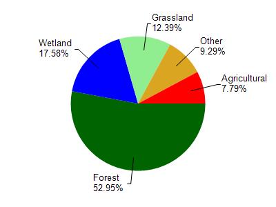
Mosinee Flowage is located in the Johnson and Peplin Creeks watershed which is 63.06 mi². Land use in the watershed is primarily forest (53%), wetland (17.60%) and a mix of grassland (12.40%) and other uses (17.10%). This watershed has stream miles, lake acres and 4,229.77 wetland acres.
Nonpoint Source Characteristics
This watershed is ranked Medium for runoff impacts on streams, Low for runoff impacts on lakes and Low for runoff impacts on groundwater and therefore has an overall rank of Low. This value can be used in ranking the watershed or individual waterbodies for grant funding under state and county programs.However, all waters are affected by diffuse pollutant sources regardless of initial water quality. Applications for specific runoff projects under state or county grant programs may be pursued. For more information, go to surface water program grants.