Prairie Dell Pond, Prairie River Watershed (UW30)
Prairie Dell Pond (1483900)
8.70 Acres
Natural Community
Natural communities (stream and lake natural communities) represent model results that use predicted flow and temperature based on landscape features and related assumptions. Ranges of flow and temperature associated with specific aquatic life communities (fish, macroinvertebrates) help biologists identify appropriate resource management goals. Wisconsin Natural Communities.
Impounded Flowing Water
Year Last Monitored
This is the most recent date of monitoring data stored in SWIMS. Additional surveys for fish and habitat may be available subsequent to this date.
Unknown
 
Lincoln
Trout Water 
Trout Waters are represented by Class I, Class II or Class III waters. These classes have specific ecological characteristics and management actions associated with them. For more information regarding Trout Classifications, see the Fisheries Trout Class Webpages.
No
Outstanding or Exceptional 
Wisconsin has designated many of the state's highest quality waters as Outstanding Resource Waters (ORWs) or Exceptional Resource Waters (ERWs). Waters designated as ORW or ERW are surface waters which provide outstanding recreational opportunities, support valuable fisheries and wildlife habitat, have good water quality, and are not significantly impacted by human activities. ORW and ERW status identifies waters that the State of Wisconsin has determined warrant additional protection from the effects of pollution. These designations are intended to meet federal Clean Water Act obligations requiring Wisconsin to adopt an 'antidegradation' policy that is designed to prevent any lowering of water quality - especially in those waters having significant ecological or cultural value.
No
Impaired Water 
A water is polluted or 'impaired' if it does not support full use by humans, wildlife, fish and other aquatic life and it is shown that one or more of the pollutant criteria are not met.
No

Fish and Aquatic Life

Current Use
The use the water currently supports. This is not a designation or classification; it is based on the current condition of the water. Information in this column is not designed for, and should not be used for, regulatory purposes.
Impounded Flowing Water
This classification includes waterbodies created by dams (mill ponds, reservoirs, flowages, and other impoundments) with a residence time of 14 days or more (under summer (June – Sept) mean low flow conditions with a 1 in 10 year recurrence interval (US EPA 2000)). Many natural lakes also have dams or water level control structures. However, to be included in the Impounded Flowing Waters category, the dam or water level control structure, must account for more than half of a waterbody’s maximum depth. Impoundments with a residence time of less than 14 days should be covered under the rivers and stream assessment methodology process.
Attainable Use
The use that the investigator believes the water could achieve through managing "controllable" sources. Beaver dams, hydroelectric dams, low gradient streams, and naturally occurring low flows are generally not considered controllable. The attainable use may be the same as the current use or it may be higher.
Supported Aquatic Life
Waters that support fish and aquatic life communities (healthy biological communities).
Designated Use
This is the water classification legally recognized by NR102 and NR104, Wis. Adm. Code. The classification determines water quality criteria and effluent limits. Waters obtain designated uses through classification procedures.
Default FAL
Fish and Aquatic Life - Default Waters do not have a specific use designation subcategory but are considered fishable, swimmable waters.

Overview

, in the Prairie River Watershed, is a 71.86 acre lake that falls in Lincoln County. This lake is managed for fishing and swimming and is currently not considered impaired.

Date  2011

Author   Aquatic Biologist

Historical Description

Source: 1982, Surface Water Resources of Lincoln County Prairie Dell Pond, T32N, R7E, Sec. 12 Surface Acres = 82.8, Maximum Depth = 40 feet, Secchi Disc = 4 feet A medium hard water drainage lake (impoundment) on the Prairie River having slightly acid, light brown water of low transparency. The shoreline is 80 percent upland of hardwoods and cleared farmland and 20 percent shrub bog wetland. Forty percent of the lake area is less than 3 feet deep. The littoral zone is 45 percent sand, 45 percent muck, 9 percent gravel and 1 percent rubble. There are 2 inlets, the Prairie River and-Big Haymeadow Creek, both of which are navigable. The outlet is the Prairie River which is tributary to the Wisconsin River. The known fish population consists of northern pike, largemouth bass and panfish. Muskrat and otter are present as well as nesting puddle ducks. The nature of the lake suggests spring and fall migratory waterfowl use. Public access with parking is provided by Lincoln County, as well as navigable water access via the Prairie River. There are 9 dwellings, one boat rental and a public park with a picnic site on the flowage. The water control structure is owned by Lincoln County and has a head of 45 feet.

Date  1982

Author   Surface Water Inventory Of Wisconsin

Prairie Dell Pond, Prairie River Watershed (UW30) Fish and Aquatic LifePrairie Dell Pond, Prairie River Watershed (UW30) RecreationPrairie Dell Pond, Prairie River Watershed (UW30) Fish Consumption

Condition

Wisconsin has over 84,000 miles of streams, 15,000 lakes and milllions of acres of wetlands. Assessing the condition of this vast amount of water is challenging. The state's water monitoring program uses a media-based, cross-program approach to analyze water condition. An updated monitoring strategy (2015-2020) is now available. Compliance with Clean Water Act fishable, swimmable standards are located in the Executive Summary of Water Condition in 2018. See also the 'monitoring and projects' tab.

Management Goals

Wisconsin's Water Quality Standards provide qualitative and quantitative goals for waters that are protective of Fishable, Swimmable conditions [Learn more]. Waters that do not meet water quality standards are considered impaired and restoration actions are planned and carried out until the water is once again fishable and swimmable

Management goals can include creation or implementation of a Total Maximum Daily Load analysis, a Nine Key Element Plan, or other restoration work, education and outreach and more. If specific recommendations exist for this water, they will be displayed below online.

Monitoring

Monitoring the condition of a river, stream, or lake includes gathering physical, chemical, biological, and habitat data. Comprehensive studies often gather all these parameters in great detail, while lighter assessment events will involve sampling physical, chemical and biological data such as macroinvertebrates. Aquatic macroinvertebrates and fish communities integrate watershed or catchment condition, providing great insight into overall ecosystem health. Chemical and habitat parameters tell researchers more about human induced problems including contaminated runoff, point source dischargers, or habitat issues that foster or limit the potential of aquatic communities to thrive in a given area. Wisconsin's Water Monitoring Strategy was recenty updated.

Grants and Management Projects

Monitoring Projects

Watershed Characteristics

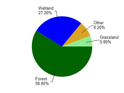
Prairie Dell Pond is located in the Prairie River watershed which is 263.99 mi². Land use in the watershed is primarily forest (58.80%), wetland (27.20%) and a mix of grassland (5.80%) and other uses (8.20%). This watershed has 273.14 stream miles, 2,082.78 lake acres and 34,162.59 wetland acres.

Nonpoint Source Characteristics

This watershed is ranked Medium for runoff impacts on streams, Medium for runoff impacts on lakes and Low for runoff impacts on groundwater and therefore has an overall rank of Low. This value can be used in ranking the watershed or individual waterbodies for grant funding under state and county programs.However, all waters are affected by diffuse pollutant sources regardless of initial water quality. Applications for specific runoff projects under state or county grant programs may be pursued. For more information, go to surface water program grants.

Natural Community

Prairie Dell Pond is considered a Impounded Flowing Water under the state's Natural Community Determinations.

Natural communities (stream and lake natural communities) represent model results and DNR staff valiation processes that confirm or update predicted conditions based on flow and temperature modeling from historic and current landscape features and related variables. Predicated flow and temperatures for waters are associated predicated fish assemblages (communities). Biologists evaluate the model results against current survey data to determine if the modeled results are corect and whether biological indicators show water quaity degradation. This analysis is a core component of the state's resource management framework. Wisconsin's Riverine Natural Communities.

This classification includes waterbodies created by dams (mill ponds, reservoirs, flowages, and other impoundments) with a residence time of 14 days or more (under summer (June – Sept) mean low flow conditions with a 1 in 10 year recurrence interval (US EPA 2000)). Many natural lakes also have dams or water level control structures. However, to be included in the Impounded Flowing Waters category, the dam or water level control structure, must account for more than half of a waterbody’s maximum depth. Impoundments with a residence time of less than 14 days should be covered under the rivers and stream assessment methodology process.

More Interactive Maps