Portage
No
No
No
Fish and Aquatic Life
Overview
The Wisconsin River Flowages in Portage County are a series of three impoundments on the Wisconsin River used to generate power for papermills. In this report they will be numbered one through three, with number one southern most, number two in the center, and number three the farthest north. All three contain turbid, dark brown soft water.
Wisconsin River Flowage Number 1 is the smallest and most shallow of the flowages. It is 57 acres in size and has a maximum depth of six feet. Sand, silt, and rubble are the predominant bottom materials, with some boulders present. The dam is known as the Whiting-Plover dam, and it is owned by the Whiting-Plover Paper Corporation, which uses it to produce power. Developments consist of the mill, seven dwellings, and a county park. The park offers picnicking, grills, and toilets. There are no boat launching facilities.
Wisconsin River Flowage Number 2, formed by the Lower Stevens Point dam is both larger and deeper than number 1. It has a maximum depth of 25 feet near the dam and covers 220 surface acres. Sand, silt, and a little gravel comprise the bottom materials. The dam is owned and maintained by the Consolidated Paper Corporation. The paper mill, seven dwellings, and a county park are present. Grills, picnic tables, and toilets are present in the park. There are no boat launching facilities.
Wisconsin River Flowage Number 3, formed by the Stevens Point dam, is the largest. It covers 2,093 acres, and is 25 feet deep near the dam which is owned by the Consolidated Paper Corporation. This impoundment is shallow at the upper end. Many bayous and backwater regions are present at the upper end which is relatively wild and undeveloped. Sand and silt are the bottom materials. A large number of developments are present on the lower end as the City of Stevens Point adjoins the water. Three city parks are located on the Flowage. Mead Park offers swimming, changehouse, picnic tables, playground, and tennis courts. Bukolt Park has playground, picnic area, bathhouse, swimming beach, boat launching ramp, and large parking area. The third, Pfieffer Park, has a small parking area, resting benches, and a tourist information booth.
The fishery of all three is the same; northern pike, walleye, bullheads, carp, white sucker, and redhorse are the most common. Perch, largemouth bass, bluegills, black crappie, rock bass, pumpkinseed, bowfin, and burbot are also present. Presence of mercury in Wisconsin River fish has been noted and consumption is presently restricted due to the high levels of mercury they contain. Further discussion of pollution will be done in another section. Although partially developed, much of the shoreline is in a wild state. Deer, grouse, muskrats, many species of waterfowl, and birds of all kinds abound, especially in the backwater regions of Flowage Number 3.
The recreational use of these flowages in the past have been quite large. Hunting, fishing, all water sports, camping, and sightseeing are among the uses. The long standing abuse of these waters has seriously lowered their quality and threatens to destroy their potential for furnishing the high quality recreation expected from a surface water resource of this magnitude.
Source: 1972, Surface Water Resources of Portage County Wisconsin River Flowages, T23, 24N, R8E, Sections--Many, Surface Acres-2,370, Maximum Depth-25 feet
Date 1972
Author Aquatic Biologist
Management Goals
Wisconsin's Water Quality Standards provide qualitative and quantitative goals for waters that are protective of Fishable, Swimmable conditions [Learn more]. Waters that do not meet water quality standards are considered impaired and restoration actions are planned and carried out until the water is once again fishable and swimmable
Management goals can include creation or implementation of a Total Maximum Daily Load analysis, a Nine Key Element Plan, or other restoration work, education and outreach and more. If specific recommendations exist for this water, they will be displayed below online.
Monitoring
Monitoring the condition of a river, stream, or lake includes gathering physical, chemical, biological, and habitat data. Comprehensive studies often gather all these parameters in great detail, while lighter assessment events will involve sampling physical, chemical and biological data such as macroinvertebrates. Aquatic macroinvertebrates and fish communities integrate watershed or catchment condition, providing great insight into overall ecosystem health. Chemical and habitat parameters tell researchers more about human induced problems including contaminated runoff, point source dischargers, or habitat issues that foster or limit the potential of aquatic communities to thrive in a given area. Wisconsin's Water Monitoring Strategy was recenty updated.
Grants and Management Projects
Monitoring Projects
| WBIC | Official Waterbody Name | Station ID | Station Name | Earliest Fieldwork Date | Latest Fieldwork Date | View Station | View Data |
|---|
| 1409400 | Wisconsin R Fl C3-Stevens Pt | 503006 | Wisconsin River - Bukolt Park (Stev Pt) | 6/27/1977 | 8/23/2023 | Map | Data |
| 1409400 | Wisconsin R Fl C3-Stevens Pt | 10017736 | Wisconsin River -- Access at Bukolt County Park | 5/17/2003 | 7/9/2021 | Map | Data |
| 1409400 | Wisconsin R Fl C3-Stevens Pt | 10005073 | Wis River Flowage #3 - Stevens Point | 6/1/1993 | 9/30/2017 | Map | Data |
| 1179900 | Wisconsin River | 503006 | Wisconsin River - Bukolt Park (Stev Pt) | 6/27/1977 | 8/23/2023 | Map | Data |
|
Watershed Characteristics
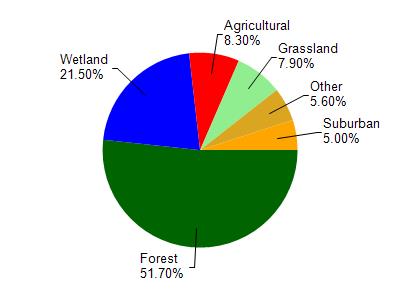
Wisconsin R Fl C3-Stevens Pt is located in the Little Eau Claire River watershed which is 126.97 mi². Land use in the watershed is primarily forest (51.70%), wetland (21.50%) and a mix of agricultural (8.30%) and other uses (18.50%). This watershed has stream miles, lake acres and 20,363.86 wetland acres.
Nonpoint Source Characteristics
This watershed is ranked Medium for runoff impacts on streams, Low for runoff impacts on lakes and Low for runoff impacts on groundwater and therefore has an overall rank of Low. This value can be used in ranking the watershed or individual waterbodies for grant funding under state and county programs.However, all waters are affected by diffuse pollutant sources regardless of initial water quality. Applications for specific runoff projects under state or county grant programs may be pursued. For more information, go to surface water program grants.