Portage
No
No
No
Fish and Aquatic Life
Overview
Lake DuBay, in the Johnson and Peplin Creeks, Little Eau Claire River, Little Eau Pleine River, Mill Creek and Mosinee Flowage Watersheds, is a 4,649.20 acre impoundment that falls in Marathon and Portage Counties. This impoundment is managed for fishing and swimming and is currently considered impaired.
Date 2015
Author Aquatic Biologist
Historical Description
Source: 1977, Surface Water Resources of Marathon County
Lake DuBay, T26N, R7E, Section 33
Surface Acres = 6,653, Maximum Depth = 30 feet, Secchi Disk = Not
available
A soft water drainage lake (impoundment) having slightly acid,
medium brown water of low transparency. The immediate shoreline
is predominantly upland (95 percent) with the remainder being
wetland. Sand is the dominant littoral material, with lesser
amounts of rubble, gravel and muck. Fish inhabiting the flowage
include walleye, northern pike, yellow perch, black crappie,
pumpkinseed, black bullhead, brown bullhead, white sucker and carp.
Migratory waterfowl make considerable use of this flowage.
Emergent and submergent vegetation are common in the littoral area.
Public access is possible from one county and two state access
points. Of the flowage's 42.3 miles of shoreline, 0.9 mile is
public. Developments on the shoreline include 122 dwellings, a
wayside park, Ashley County Park and DuBay County Park. The water
control structure, owned by the Consolidated Water Power Company,
is used to generate electric power. The dam has a head of 25 feet.
Streams entering the flowage include the Wisconsin River, the Big
Eau Pleine River, the Little Eau Pleine River, the Little Eau
Claire River, Peplin Creek, Johnson Creek, Hog Creek and five
unnamed streams. Although Lake DuBay extends into Portage County,
the acreage and shoreline figures for Marathon County represent the
entire flowage. In 1977 the flowage experienced a winterkill, the
first of any significance known to have occurred. This
circumstance was likely precipitated by a significantly reduced
stream flow in the Wisconsin River due to drought conditions.
Date 1977
Author Surface Water Inventory Of Wisconsin
Management Goals
Wisconsin's Water Quality Standards provide qualitative and quantitative goals for waters that are protective of Fishable, Swimmable conditions [Learn more]. Waters that do not meet water quality standards are considered impaired and restoration actions are planned and carried out until the water is once again fishable and swimmable
Management goals can include creation or implementation of a Total Maximum Daily Load analysis, a Nine Key Element Plan, or other restoration work, education and outreach and more. If specific recommendations exist for this water, they will be displayed below online.
Monitoring
Monitoring the condition of a river, stream, or lake includes gathering physical, chemical, biological, and habitat data. Comprehensive studies often gather all these parameters in great detail, while lighter assessment events will involve sampling physical, chemical and biological data such as macroinvertebrates. Aquatic macroinvertebrates and fish communities integrate watershed or catchment condition, providing great insight into overall ecosystem health. Chemical and habitat parameters tell researchers more about human induced problems including contaminated runoff, point source dischargers, or habitat issues that foster or limit the potential of aquatic communities to thrive in a given area. Wisconsin's Water Monitoring Strategy was recenty updated.
Grants and Management Projects
Monitoring Projects
| WBIC | Official Waterbody Name | Station ID | Station Name | Earliest Fieldwork Date | Latest Fieldwork Date | View Station | View Data |
|---|
| 1412200 | Lake Du Bay | 10052708 | Lake Du Bay - Lake Dubay Beach | 7/25/2018 | 8/23/2023 | Map | Data |
|
Watershed Characteristics
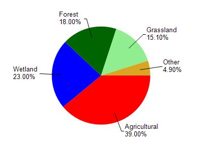
Lake Du Bay is located in the Little Eau Pleine River watershed which is 263.30 mi². Land use in the watershed is primarily agricultural (39%), wetland (23%) and a mix of forest (18%) and other uses (20.00%). This watershed has stream miles, lake acres and 38,285.37 wetland acres.
Nonpoint Source Characteristics
This watershed is ranked Low for runoff impacts on streams, Low for runoff impacts on lakes and High for runoff impacts on groundwater and therefore has an overall rank of High. This value can be used in ranking the watershed or individual waterbodies for grant funding under state and county programs.However, all waters are affected by diffuse pollutant sources regardless of initial water quality. Applications for specific runoff projects under state or county grant programs may be pursued. For more information, go to surface water program grants.