Douglas
No
No
Yes
Fish and Aquatic Life
Overview
Hog Island was contaminated with metals and PAHs from activities associated with the Murphy Oil Refinery in Superior. In 2005 and 2006, the area was remediated using funds from the Great Lake Legacy Act and from Murphy Oil. In 2007, a plan was developed to restore habitat at the site. Douglas County has adopted some of the actions in the plan, and has been implementing those actions with funding from the National Oceanic and Atmospheric Administration in 2009 and 2010 and will continue work at the site in 2011.
Date 2011
Author Nancy Larson
Historical Description
Newton Creek is an approximately 1.8 mile long stream located within the City of Superior. It is a tributary to Hog Island Inlet, on the southeastern end of Superior Bay. Newton Creek drains a wetland area just west of the Murphy Oil refinery in Superior, Wisconsin and flows through industrial and residential areas before emptying into the approximately 17-acre inlet. While the wetland area contributes to baseflow, without discharge from Murphy Oil as its primary source water, Newton Creek would otherwise be intermittent at times. In 1990, Newton Creek was recommended for classification as limited forage fishery (LFF) (Newton Creek/Hog Island Inlet, Douglas County, Murphy Oil WWTP Use Designation, Bub), based primarily on low and potentially intermittent natural flows. Hog Island Inlet was recommended to be classified for fish and aquatic life uses consistent with great lakes communities.
Newton Creek and Hog Island Inlet were both added to the federal 303(d) list of impaired waters for chronic aquatic toxicity in April, 1998. Prior to remediation efforts, Newton Creek contained only limited aquatic life due to severe pollution, with contamination from Murphy Oil into Newton Creek and Hog Island Inlet well documented (see Lake Superior Basin Water Quality Management Plan, WDNR, 1999; Construction Documentation and Post-Remediation Monitoring Report, WDNR and SEH, 2007). During studies of the two waters, WDNR had determined that exposure to PAH-contaminated sediments and suspended sediments in the water column posed unacceptable risks to human health and the environment. In addition to PAH’s, pollutants of concern included diesel range organics, metals, and high phosphorus levels among other substances resulting in acute and chronic toxicity to aquatic life, as well as dissolved oxygen levels in some reaches that sometimes were below 5 mg/l.
The WDNR divided Newton Creek into 12 segments (A through L) in 1994 in order to organize cleanup efforts. Reclamation Segment A, an impoundment area at Murphy Oil, was done by Murphy Oil under WDNR supervision in 1997. This was followed by cleanup of Segments B through K in the summer of 2003. The final phase occurred between July to November 2005 with the removal of contaminated sediment from 15 acres of Hog Island Inlet and also Segment L of Newton Creek using funds from the Great Lakes Legacy Act. Wisconsin DNR partnered with the EPA’s Great lakes National Program Office to complete this portion of the project. In all, nearly 55,000 tons of contaminated sediment was removed from Newton Creek and Hog Island Inlet.
Post-remediation monitoring and sampling was conducted in Newton Creek and Hog Island Inlet following cleanup efforts. PAH contamination levels in the sediment did not appear to pose unacceptable risks to human health or the environment and results from macroinvertebrate sampling in 2006 indicated some positive steps toward recovery and potential future delisting. However, it was clear that recovery of aquatic life and complete biological recolonization of Newton Creek and Hog Island Inlet to levels appropriate to use designations assigned for each waterbody, respectively, would take more time after reclamation efforts (Schmude, 2006). In addition to acceptable levels of cleanup of pollutants and contaminated sediment, it was determined that biological recovery would need to take place before de-listing could take place.
In 2008, a three-year special project was proposed that is currently ongoing (2008-2011) to assess the continued biological recoveryof Newton Creek and Hog Island Inlet after remediation/restoration efforts. Preliminary findings in 2008-09 indicate at least some improvement in the biological diversity from 2006 levels. Biological monitoring should continue through 2010. Results obtained during all years of this monitoring will determine if either waterbody can be delisted from the 303d list of impaired waters. Additionally, a plan was developed in 2007 for habitat restoration of Hog Island Inlet. Douglas County has adopted some of the actions in the plan, and has been implementing those actions with funding from the National Oceanic and Atmospheric Administration in 2009 and 2010 and will continue work at the site in 2011.
Date 2011
Author Nancy Larson
Condition
Wisconsin has over 84,000 miles of streams, 15,000 lakes and milllions of acres of wetlands. Assessing the condition of this vast amount of water is challenging. The state's water monitoring program uses a media-based, cross-program approach to analyze water condition. An updated monitoring strategy (2015-2020) is now available. Compliance with Clean Water Act fishable, swimmable standards are located in the Executive Summary of Water Condition in 2018. See also the 'monitoring and projects' tab.
Reports
Management Goals
Wisconsin's Water Quality Standards provide qualitative and quantitative goals for waters that are protective of Fishable, Swimmable conditions [Learn more]. Waters that do not meet water quality standards are considered impaired and restoration actions are planned and carried out until the water is once again fishable and swimmable
Management goals can include creation or implementation of a Total Maximum Daily Load analysis, a Nine Key Element Plan, or other restoration work, education and outreach and more. If specific recommendations exist for this water, they will be displayed below online.
Monitoring
Monitoring the condition of a river, stream, or lake includes gathering physical, chemical, biological, and habitat data. Comprehensive studies often gather all these parameters in great detail, while lighter assessment events will involve sampling physical, chemical and biological data such as macroinvertebrates. Aquatic macroinvertebrates and fish communities integrate watershed or catchment condition, providing great insight into overall ecosystem health. Chemical and habitat parameters tell researchers more about human induced problems including contaminated runoff, point source dischargers, or habitat issues that foster or limit the potential of aquatic communities to thrive in a given area. Wisconsin's Water Monitoring Strategy was recenty updated.
Grants and Management Projects
| Project Name (Click for Details) | Year Started |
|---|
|
|
Monitoring Projects
| WBIC | Official Waterbody Name | Station ID | Station Name | Earliest Fieldwork Date | Latest Fieldwork Date | View Station | View Data |
|---|
| 2751220 | Lake Superior | 163250 | Lake Superior-Hog Island Inlet - Super Har Hi-3 | 6/21/1993 | 6/21/1993 | Map | Data |
| 2751220 | Lake Superior | 163345 | Hog Island Inlet-Hog Island Inlet - East Hi-21 | 7/13/1994 | 7/13/1994 | Map | Data |
| 2751220 | Lake Superior | 10047274 | Lake Superior at Hog Island Inlet (HI16-Sed 3) | 8/11/2016 | 8/11/2016 | Map | Data |
| 2751220 | Lake Superior | 163081 | Superior Harbor - Mouth Hog Island Inlet | 8/26/1976 | 4/6/1993 | Map | Data |
| 2751220 | Lake Superior | 163352 | Hog Island Inlet - Center Hi-28 | | | Map | Data |
| 2751220 | Lake Superior | 10048086 | Hog Island Inlet HOG 52 | 9/7/2016 | 9/17/2023 | Map | Data |
| 2751220 | Lake Superior | 10047275 | Lake Superior at Hog Island Inlet (HI16-Sed 4) | 8/11/2016 | 8/11/2016 | Map | Data |
| 2751220 | Lake Superior | 163080 | Superior Harbor - Hog Island Inlet | 8/26/1976 | 6/21/1989 | Map | Data |
| 2751220 | Lake Superior | 163348 | Hog Island Inlet - East Hi-24 | | | Map | Data |
| 2751220 | Lake Superior | 163360 | Hog Island Inlet - West Hi - 36 | | | Map | Data |
| 2751220 | Lake Superior | 10047272 | Lake Superior at Hog Island Inlet (HI16-Sed 5) | 8/11/2016 | 8/11/2016 | Map | Data |
| 2751220 | Lake Superior | 163349 | Lake Superior-Hog Island Inlet - Center Hi-25 | 7/13/1994 | 7/13/1994 | Map | Data |
| 2751220 | Lake Superior | 163093 | Hog Island Inlet-Hog Island Inlet - 20' Ne Of Newton Creek | 6/6/1976 | 6/21/1989 | Map | Data |
| 2751220 | Lake Superior | 163257 | Lake Superior-Hog Island Inlet - Super Har Hi-9 | 6/24/1993 | 6/25/1993 | Map | Data |
| 2751220 | Lake Superior | 163094 | Hog Island Inlet - 200' E Of Newton Cr | 6/7/1976 | 6/21/1989 | Map | Data |
| 2751220 | Lake Superior | 163252 | Lake Superior-Hog Island Inlet - Super Har Hi5c | 6/22/1992 | 6/22/1993 | Map | Data |
| 2751220 | Lake Superior | 163253 | Lake Superior-Hog Island Inlet - Super Har Hi-5 | 6/22/1993 | 6/22/1993 | Map | Data |
| 2751220 | Lake Superior | 163357 | Lake Superior-Hog Island Inlet - Center Hi-33 | 7/20/1994 | 7/20/1994 | Map | Data |
| 2751220 | Lake Superior | 163265 | Lake Superior-Hog Island Inlet - Super Har Hi16 | 6/24/1993 | 6/24/1993 | Map | Data |
| 2751220 | Lake Superior | 163264 | Lake Superior-Hog Island Inlet - Super Har Hi15 | 6/22/1993 | 6/22/1993 | Map | Data |
| 2751220 | Lake Superior | 10048088 | Hog Island Inlet HOG 61 | 9/7/2016 | 9/17/2023 | Map | Data |
| 2751220 | Lake Superior | 163353 | Hog Island Inlet-Hog Island Inlet - Center Hi-29 | 7/18/1994 | 7/18/1994 | Map | Data |
| 2751220 | Lake Superior | 163256 | Lake Superior-Hog Island Inlet - Super Har Hi-8 | 6/24/1993 | 6/25/1993 | Map | Data |
| 2751220 | Lake Superior | 163249 | Hog Island Inlet-Hog Island Inlet - Super Har Hi-2 | 6/21/1993 | 7/13/1994 | Map | Data |
| 2751220 | Lake Superior | 10048089 | Hog Island Inlet HOG 84 | 9/7/2016 | 9/17/2023 | Map | Data |
| 2751220 | Lake Superior | 163255 | Lake Superior-Hog Island Inlet - Super Har Hi-7 | 6/23/1993 | 7/14/1993 | Map | Data |
| 2751220 | Lake Superior | 163259 | Lake Superior-Hog Island Inlet - Super Har Hi11 | 6/22/1993 | 6/22/1993 | Map | Data |
| 2751220 | Lake Superior | 163262 | Lake Superior-Hog Island Inlet - Super Har Hi13 | 6/24/1993 | 6/24/1993 | Map | Data |
| 2751220 | Lake Superior | 163296 | Hog Island Inlet-Hog Island Inlet - Sup Harb Wl-1 /East End | 6/21/1993 | 7/12/1994 | Map | Data |
| 2751220 | Lake Superior | 10047273 | Lake Superior at Hog Island Inlet (HI16-Sed 2) | 8/11/2016 | 8/11/2016 | Map | Data |
| 2751220 | Lake Superior | 163254 | Lake Superior-Hog Island Inlet - Super Har Hi-6 | 6/22/1993 | 6/22/1993 | Map | Data |
| 2751220 | Lake Superior | 163359 | Hog Island Inlet - West Hi - 35 | | | Map | Data |
| 2751220 | Lake Superior | 10037603 | NEWTON CREEK SUPERIOR - HI-13-TX | 7/20/1994 | 7/20/1994 | Map | Data |
| 2751220 | Lake Superior | 163347 | Lake Superior-Hog Island Inlet - East Hi-23 | 7/13/1994 | 7/13/1994 | Map | Data |
| 2751220 | Lake Superior | 163284 | Superior Bay-Hog Island Inlet - Hog Is Inl Mouth Sb-2 | 6/17/1993 | 6/17/1993 | Map | Data |
| 2751220 | Lake Superior | 10037592 | NEWTON CREEK SUPERIOR - HI-30-TX | 7/20/1994 | 9/17/2023 | Map | Data |
| 2751220 | Lake Superior | 163230 | Hog Island Inlet-Hog Island Inlet - Hi1-2 /Superior Harbor | 2/4/1993 | 2/4/1993 | Map | Data |
| 2751220 | Lake Superior | 163266 | Hog Island Inlet-Hog Island Inlet - Super Har Hi17 | 6/16/1993 | 7/14/1993 | Map | Data |
| 2751220 | Lake Superior | 163340 | Superior Bay - Sb-4 | | | Map | Data |
| 2751220 | Lake Superior | 163354 | Hog Island Inlet Near Newton Cr Mouth Center Hi-30 | 7/14/1994 | 6/24/2011 | Map | Data |
| 2751220 | Lake Superior | 163363 | Hog Island Inlet-Hog Island Inlet - West Hi - 39 | 7/15/1994 | 7/15/1994 | Map | Data |
| 2751220 | Lake Superior | 163248 | Hog Island Inlet-Hog Island Inlet - Super Har Hi-1 | 6/21/1993 | 9/17/2023 | Map | Data |
| 2751220 | Lake Superior | 163263 | Lake Superior-Hog Island Inlet - Super Har Hi14 | 6/22/1993 | 6/22/1993 | Map | Data |
| 2751220 | Lake Superior | 163282 | Superior Bay-Hog Island Inlet - Hog Is Inl M Sb1sc | 6/16/1993 | 6/17/1993 | Map | Data |
| 2751220 | Lake Superior | 163283 | Hog Island Inlet Super Bay - M Sb1sd | | | Map | Data |
| 2751220 | Lake Superior | 10037601 | NEWTON CREEK SUPERIOR - HI-1-TX | 7/20/1994 | 7/20/1994 | Map | Data |
| 2751220 | Lake Superior | 163092 | Hog Island Inlet - 200' N.Of Newton Cr | 6/7/1976 | 6/21/1989 | Map | Data |
| 2751220 | Lake Superior | 163260 | Lake Superior-Hog Island Inlet - Super Har Hi12 | 6/24/1993 | 6/24/1993 | Map | Data |
| 2751220 | Lake Superior | 10048084 | Hog Island Inlet HOG 22 | 9/7/2016 | 9/17/2023 | Map | Data |
| 2751220 | Lake Superior | 163258 | Lake Superior-Hog Island Inlet - Super Har Hi10 | 7/12/1993 | 9/17/2023 | Map | Data |
| 2751220 | Lake Superior | 163285 | Superior Bay-Hog Island Inlet-Mouth Sb-3 Near Inlet Opening | 6/17/1993 | 7/15/1994 | Map | Data |
| 2751220 | Lake Superior | 163350 | Hog Island Inlet - Center Hi-26 | | | Map | Data |
| 2751220 | Lake Superior | 10037602 | NEWTON CREEK SUPERIOR - WL-1-TX | 8/8/1994 | 8/8/1994 | Map | Data |
| 2751220 | Lake Superior | 163355 | Hog Island Inlet - Center Hi-31 | | | Map | Data |
| 2751220 | Lake Superior | 163229 | Hog Island Inlet-Hi1-1 /Superior Harbor Near Cr Mouth | 2/4/1993 | 2/4/1993 | Map | Data |
| 2751220 | Lake Superior | 10047270 | Lake Superior at Hog Island Inlet (HI16-Sed 1) | 8/9/2016 | 8/9/2016 | Map | Data |
| 2751220 | Lake Superior | 163261 | Hog Island Inlet-Hog Island Inlet - Super Hi-13-Sc | 6/24/1993 | 7/20/1994 | Map | Data |
| 2751220 | Lake Superior | 163351 | Hog Island Inlet-Hog Island Inlet - Center Hi-27 | 7/18/1994 | 7/20/1994 | Map | Data |
| 2751220 | Lake Superior | 10048085 | Hog Island Inlet HOG 25 | 9/7/2016 | 9/17/2023 | Map | Data |
| 2751220 | Lake Superior | 163251 | Lake Superior-Hog Island Inlet - Super Har Hi-4 | 6/22/1993 | 6/22/1993 | Map | Data |
| 2751220 | Lake Superior | 10048087 | Hog Island Inlet HOG 65 | 9/7/2016 | 9/17/2023 | Map | Data |
| 2751220 | Lake Superior | 10029968 | Hog Island Inlet - Minifyke Netting | | | Map | Data |
|
Watershed Characteristics
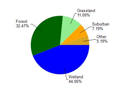
Superior Bay is located in the St. Louis and Lower Nemadji River watershed which is 159.67 mi². Land use in the watershed is primarily wetland (44.10%), forest (32.50%) and a mix of grassland (11.10%) and other uses (12.40%). This watershed has 432.66 stream miles, 8,490.75 lake acres and 26,945.85 wetland acres.
Nonpoint Source Characteristics
This watershed is ranked Not Ranked for runoff impacts on streams, Not Available for runoff impacts on lakes and Low for runoff impacts on groundwater and therefore has an overall rank of Low. This value can be used in ranking the watershed or individual waterbodies for grant funding under state and county programs.However, all waters are affected by diffuse pollutant sources regardless of initial water quality. Applications for specific runoff projects under state or county grant programs may be pursued. For more information, go to surface water program grants.