Sheboygan
No
No
No
Fish and Aquatic Life
Overview
FISHERMAN’S CREEK TRIBUTARY TO BLACK RIVER AT RM 0.3
T14N R23E Sec. 2 SESW Stream Length = 2.1 WBIC = 50400
This creek is a 2.1-mile-long tributary of the Black River, originating in the City of Sheboygan and joining the Black River three tenths of a mile upstream of Lake Michigan. Urban land use dominates the downstream half of the stream, while industry and urban development in conjunction with limited agricultural uses are in the upstream portion. Urban stormwater runoff from the City of Sheboygan discharges into the creek. In addition, the stream receives leachate from the old town of Wilson landfill site as well as runoff via a small unnamed tributary through a fly ash tailings pond operated by the Edgewater Power Plant. Other potential impacts to water quality are the thermal discharge from Thomas Industries which may be impacting aquatic organisms in the upper reaches of Fisherman’s Creek and runoff from the former Conoco Refinery property (WDNR 1988, 1995).
Wetlands at the headwaters of Fisherman’s Creek were filled for industrial development. The creek was dredged and rerouted in 1991 to abate flooding problems caused by the loss of those wetlands. Channelized reaches with impervious surfaces within the creek still contribute to flooding downstream of the industrial parks. The results are severe streambank erosion and flooding, particularly in the lower reaches. A large-scale fish kill occurred in the summer of 1992, resulting from a fire-controlled spill at E&K Hazardous Waste Services. The fish died due to high biological oxygen demand. Fisherman’s Creek is classified as a Warm Water Forage Fish community stream. Fish community assessments were conducted in Fisherman’s Creek in 1985 and during the 1994 basin monitoring (Table 19). Fourteen fish species were identified in Fisherman’s Creek during fish community assessments conducted during 1994 (Table 19). The brook trout we collected in 1994 is not a resident of Fisherman’s Creek, but it along with other species of trout and salmon resident to Lake Michigan, migrate into Fisherman’s Creek on a seasonal basis. Due to natural limiting conditions (i.e. warm water temperatures), trout and salmon are not capable of reproducing in Fisherman’s Creek.
A fish survey conducted in the headwaters of Fisherman’s Creek didn’t find any fish upstream of the Indian Meadows Trailer Park’s stormwater detention pond outlet upstream to the railroad tracks. The lack of fish in this reach is likely caused by a combination of poor habitat caused by stream modifications, riprap from the stormwater pond outlet structure washed into the stream blocking stream flow, and thermal stresses.
Habitat assessments were conducted as part of the three recent fish collections using the Fish Habitat Rating (FHR) (Simonson et al. 1994) and the Stream System Habitat Rating (SSHR) (Ball 1982) protocols. The macroinvertebrate community was sampled at four sites on Fisherman’s Creek and was comprised of taxa mainly tolerant to very tolerant of poor water quality. Poor habitat caused by flashy flows, high turbidity, and excessive sedimentation of course substrate, limits the macroinvertebrate community. Table 17 summarizes the biotic indices and habitat ratings.
Date 2001
Author Aquatic Biologist
Overview
Sediment Quality
Sediment samples were collected in 1994 at two sites in Fisherman’s Creek and one site on an unnamed tributary to Fisherman’s Creek (at river mile 0.3). Baseline sediment quality data for Fisherman’s Creek were collected to assess the potential sediment quality impacts from the fly ash landfill on an unnamed tributary to Fisherman’s Creek.
Total PCBs for all sites came back less than detect at <0.05 ug/g, and nine PAH compounds were observed in the sample collected in the headwaters of Fisherman’s Creek (WDNR 1999). The source of the PAH contamination is unknown, but is probably from the former Conoco Refinery Property upstream from this site. Heavy metals show an increase in concentration from upstream to downstream consistent with increased urban runoff. The metals concentrations in Fisherman’s Creek are consistent with urban environments and not perceived to be at levels of concern based on the toxicity information that we have for these constituents at this time. Consequently, Fisherman’s Creek does not require specific management activities at this time.
However, a number of the metals tested from the unnamed tributary to Fisherman’s Creek (at RM 0.3) from the Edgewater Power Plant fly ash landfill were higher than in Fisherman’s Creek just upstream from the confluence of the streams. The concentration of boron in the sediment sample was 150 mg/kg, which was an order of magnitude higher than the sample from Fisherman Creek. Boron is an essential trace element and is required for plant and animal growth, but is toxic when present in excessive amounts. Boron is highly mobile in soils; hence, the observation of elevated levels of boron is indicative of landfill leachate contamination (McGinley and Kmet 1984). The impact of the contaminated sediment from the tributary to Fisherman’s Creek is not known at this time.
Date 2001
Author Aquatic Biologist
Condition
Wisconsin has over 84,000 miles of streams, 15,000 lakes and milllions of acres of wetlands. Assessing the condition of this vast amount of water is challenging. The state's water monitoring program uses a media-based, cross-program approach to analyze water condition. An updated monitoring strategy (2015-2020) is now available. Compliance with Clean Water Act fishable, swimmable standards are located in the Executive Summary of Water Condition in 2018. See also the 'monitoring and projects' tab.
Reports
Management Goals
Wisconsin's Water Quality Standards provide qualitative and quantitative goals for waters that are protective of Fishable, Swimmable conditions [Learn more]. Waters that do not meet water quality standards are considered impaired and restoration actions are planned and carried out until the water is once again fishable and swimmable
Management goals can include creation or implementation of a Total Maximum Daily Load analysis, a Nine Key Element Plan, or other restoration work, education and outreach and more. If specific recommendations exist for this water, they will be displayed below online.
Monitoring
Monitoring the condition of a river, stream, or lake includes gathering physical, chemical, biological, and habitat data. Comprehensive studies often gather all these parameters in great detail, while lighter assessment events will involve sampling physical, chemical and biological data such as macroinvertebrates. Aquatic macroinvertebrates and fish communities integrate watershed or catchment condition, providing great insight into overall ecosystem health. Chemical and habitat parameters tell researchers more about human induced problems including contaminated runoff, point source dischargers, or habitat issues that foster or limit the potential of aquatic communities to thrive in a given area. Wisconsin's Water Monitoring Strategy was recenty updated.
Grants and Management Projects
| Project Name (Click for Details) | Year Started |
|---|
|
|
Monitoring Projects
| WBIC | Official Waterbody Name | Station ID | Station Name | Earliest Fieldwork Date | Latest Fieldwork Date | View Station | View Data |
|---|
| 50400 | Unnamed | 603233 | Black River at Lk Shore Dr Sdmt | 8/23/1978 | 3/19/1979 | Map | Data |
| 50400 | Unnamed | 603342 | Fisherman Creek - Upstream Of Ee | 3/30/1994 | 11/16/1994 | Map | Data |
| 50400 | Unnamed | 603229 | Black River Tributary At Sth 141 - South Fork | 11/13/1978 | 12/20/1994 | Map | Data |
| 50400 | Unnamed | 603232 | Black River at Lake Shore Dr | | | Map | Data |
| 50400 | Unnamed | 603409 | Fisherman'S Creek - 300' Upstream Of Confluence With Unnamed Trib | 12/21/1994 | 12/21/1994 | Map | Data |
| 50400 | Unnamed | 603410 | Fisherman'S Creek - Flyash SiteDownstream Of Lust Site | 12/19/1994 | 12/19/1994 | Map | Data |
| 50400 | Unnamed | 603234 | Unnamed Creek At 12th Street | 5/23/1994 | 11/1/2016 | Map | Data |
| 50400 | Unnamed | 10037505 | Fisherman's Creek US cth KK | 8/19/2013 | 1/1/2015 | Map | Data |
| 50400 | Unnamed | 10012997 | Fisherman Creek 30m Upstream Of 18th St | | | Map | Data |
|
Watershed Characteristics
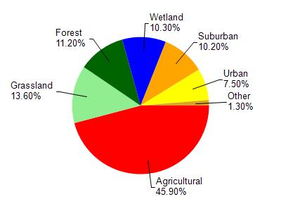
Unnamed is located in the Black River watershed which is 35.51 mi². Land use in the watershed is primarily agricultural (45.90%), grassland (13.60%) and a mix of forest (11.20%) and other uses (29.30%). This watershed has 83.77 stream miles, 6,359.43 lake acres and 2,238.69 wetland acres.
Nonpoint Source Characteristics
This watershed is ranked High for runoff impacts on streams, Not Ranked for runoff impacts on lakes and High for runoff impacts on groundwater and therefore has an overall rank of High. This value can be used in ranking the watershed or individual waterbodies for grant funding under state and county programs.However, all waters are affected by diffuse pollutant sources regardless of initial water quality. Applications for specific runoff projects under state or county grant programs may be pursued. For more information, go to surface water program grants.