La Crosse
No
No
No
Fish and Aquatic Life
Overview
Smith Valley Creek, located in central La Crosse County, flows for approximately four miles in a northerly direction before reaching the La Crosse River. It has a gradient of 46 feet per mile and drains a rural subdivision and some agricultural land. Smith Valley Creek is not a classified trout stream.
The configuration of Smith Valley, the road, stream, and development patterns have required the installation of many culverts and bridges over the creek. If these stream crossings are not designed and constructed properly, damage to the fishery, in-stream habitat, and upstream property can result. Streambank pasturing is also a problem on Smith Valley Creek. Since the most recent fishery survey of Smith Valley Creek was conducted in 1977, an updated survey should be conducted to determine the current status of the stream. Smith Valley Creek was last stocked in 1994 with brook trout. Access to the stream is from four road crossings.
Water chemistry testing of streams throughout La Crosse County was initiated by the La Crosse County Land Conservation Department in 1998. Baseflow conditions were targeted for testing as the most likely to show normal water quality conditions. Sampling takes place four times annually when no rainfall or snowmelt has occurred during the previous 72 hours. Between 1998 and 2001, Smith Valley Creek met the county phosphorus goal in 50% of the samples and the county fecal coliform bacteria goal in nearly 75% of the samples taken. The county ranks Smith Valley Creek in the bottom 25% in priority compared to other streams for efforts to reduce phosphorus and bacterial contamination. La Crosse County should continue baseflow sampling of Smith Valley Creek to determine water quality trends.
Date 2002
Author Aquatic Biologist
Condition
Wisconsin has over 84,000 miles of streams, 15,000 lakes and milllions of acres of wetlands. Assessing the condition of this vast amount of water is challenging. The state's water monitoring program uses a media-based, cross-program approach to analyze water condition. An updated monitoring strategy (2015-2020) is now available. Compliance with Clean Water Act fishable, swimmable standards are located in the Executive Summary of Water Condition in 2018. See also the 'monitoring and projects' tab.
Management Goals
Wisconsin's Water Quality Standards provide qualitative and quantitative goals for waters that are protective of Fishable, Swimmable conditions [Learn more]. Waters that do not meet water quality standards are considered impaired and restoration actions are planned and carried out until the water is once again fishable and swimmable
Management goals can include creation or implementation of a Total Maximum Daily Load analysis, a Nine Key Element Plan, or other restoration work, education and outreach and more. If specific recommendations exist for this water, they will be displayed below online.
Monitoring
Monitoring the condition of a river, stream, or lake includes gathering physical, chemical, biological, and habitat data. Comprehensive studies often gather all these parameters in great detail, while lighter assessment events will involve sampling physical, chemical and biological data such as macroinvertebrates. Aquatic macroinvertebrates and fish communities integrate watershed or catchment condition, providing great insight into overall ecosystem health. Chemical and habitat parameters tell researchers more about human induced problems including contaminated runoff, point source dischargers, or habitat issues that foster or limit the potential of aquatic communities to thrive in a given area. Wisconsin's Water Monitoring Strategy was recenty updated.
Grants and Management Projects
| Project Name (Click for Details) | Year Started |
|---|
|
|
Monitoring Projects
| WBIC | Official Waterbody Name | Station ID | Station Name | Earliest Fieldwork Date | Latest Fieldwork Date | View Station | View Data |
|---|
|
|
Watershed Characteristics
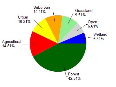
Smith Slough is located in the Lower La Crosse River watershed which is 145.46 mi². Land use in the watershed is primarily forest (42.30%), agricultural (14.80%) and a mix of urban (10.30%) and other uses (32.50%). This watershed has 295.20 stream miles, 1,187.12 lake acres and 5,641.64 wetland acres.
Nonpoint Source Characteristics
This watershed is ranked Medium for runoff impacts on streams, Not Ranked for runoff impacts on lakes and Low for runoff impacts on groundwater and therefore has an overall rank of Low. This value can be used in ranking the watershed or individual waterbodies for grant funding under state and county programs.However, all waters are affected by diffuse pollutant sources regardless of initial water quality. Applications for specific runoff projects under state or county grant programs may be pursued. For more information, go to surface water program grants.