Rock
No
No
Yes
Fish and Aquatic Life
Overview
Taylor Creek, from Swan Creek to its headwaters (miles 6.06 to 13), was evaluated in the 2016 and 2018 cycles; phosphorus, temperature, fish, and macroinvertebrates all indicated good conditions.
Date 2018
Author Ashley Beranek
Overview
Taylor Creek is a 13-mile stream that drains southward in western Rock County and empties into the Sugar River. The lower three-quarters of a mile of the stream flows through the Avon Bottoms Wildlife Area. The lower 6 miles of the stream currently support a warm water sport fishery as confirmed by a 1997 survey which found largemouth and smallmouth bass, and northern pike as well as a variety of panfish and warmwater forage species. This portion of the stream has the potential to support a cold water fishery (Bush, pers comm); however, numerous beaver dams slow and warm the water. The upper half of the stream is a warm water forage fishery.
Date 2002
Author Aquatic Biologist
Historical Description
From: Ball, Joseph R., and Ronald J. Poff, Lake and Stream Classification Project. Surface Water Resources of Rock County, Department of Natural Resources, 1970.
Surface Acres = 15.59, Miles = 13.4, Gradient = 9.85 feet per mile.
A warm water stream rising in west central Rock County and flowing south to Sugar River. The stream drains 15.6 square miles of crop and wetland and has been ditched throughout much of its length. Managed for forage species, but smallmouth bass, northern pike and catfish migrate upstream a short distance from the Sugar River. Adjoining fresh meadow wetland totals 859 acres, 15 percent of which is wooded. Approximately 3/4 mile of the stream flows through the Avon Bottoms Wildlife Area. Access is available from six county and five town roads, and two state highway crossings. In addition, navigable water access is available
from the Sugar River.
Date 1970
Author Surface Water Inventory Of Wisconsin
Impaired Waters
Taylor Creek, from its mouth to Swan Creek (miles 0 to 6.06), was placed on the impaired waters list for phosphorus in 2016. Evaluation in the 2018 cycle confirmed high phosphorus levels.
Date 2018
Author Ashley Beranek
Condition
Wisconsin has over 84,000 miles of streams, 15,000 lakes and milllions of acres of wetlands. Assessing the condition of this vast amount of water is challenging. The state's water monitoring program uses a media-based, cross-program approach to analyze water condition. An updated monitoring strategy (2015-2020) is now available. Compliance with Clean Water Act fishable, swimmable standards are located in the Executive Summary of Water Condition in 2018. See also the 'monitoring and projects' tab.
Reports
Recommendations
Citizen-Based Stream Monitoring
Collect chemical, physical, and/or biological water quality data to assess the current overall stream health. The data can inform management decisions and may be used to identify impaired waters for biennial lists.
Monitor or Propose 303(d) Listing
Taylor Creek, from Swan Creek downstream to the Sugar River and Willow Creek should be added as a watch water since total phosphorus concentrations are near the criteria for listing.
Management Goals
Wisconsin's Water Quality Standards provide qualitative and quantitative goals for waters that are protective of Fishable, Swimmable conditions [Learn more]. Waters that do not meet water quality standards are considered impaired and restoration actions are planned and carried out until the water is once again fishable and swimmable
Management goals can include creation or implementation of a Total Maximum Daily Load analysis, a Nine Key Element Plan, or other restoration work, education and outreach and more. If specific recommendations exist for this water, they will be displayed below online.
Monitoring
Monitoring the condition of a river, stream, or lake includes gathering physical, chemical, biological, and habitat data. Comprehensive studies often gather all these parameters in great detail, while lighter assessment events will involve sampling physical, chemical and biological data such as macroinvertebrates. Aquatic macroinvertebrates and fish communities integrate watershed or catchment condition, providing great insight into overall ecosystem health. Chemical and habitat parameters tell researchers more about human induced problems including contaminated runoff, point source dischargers, or habitat issues that foster or limit the potential of aquatic communities to thrive in a given area. Wisconsin's Water Monitoring Strategy was recenty updated.
Grants and Management Projects
Monitoring Projects
| WBIC | Official Waterbody Name | Station ID | Station Name | Earliest Fieldwork Date | Latest Fieldwork Date | View Station | View Data |
|---|
| 876300 | Taylor Creek | 10014326 | Taylor Creek-Upstream Of Hafeman Rd 281m To End | | | Map | Data |
| 876300 | Taylor Creek | 10021931 | Taylor Creek At Avon North Townline Rd. | 5/24/2007 | 1/1/2015 | Map | Data |
| 876300 | Taylor Creek | 10039914 | Taylor Creek at Smith Rd | 5/21/2013 | 9/5/2023 | Map | Data |
| 876300 | Taylor Creek | 10012061 | Taylor Creek - Upstream Of Sth 81 | 10/29/2004 | 10/29/2004 | Map | Data |
|
Watershed Characteristics
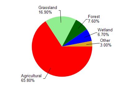
Taylor Creek is located in the Lower Sugar River watershed which is 217.85 mi². Land use in the watershed is primarily agricultural (65.80%), grassland (16.90%) and a mix of forest (7.60%) and other uses (9.70%). This watershed has 467.98 stream miles, 202.10 lake acres and 6,999.03 wetland acres.
Nonpoint Source Characteristics
This watershed is ranked Low for runoff impacts on streams, Not Ranked for runoff impacts on lakes and High for runoff impacts on groundwater and therefore has an overall rank of High. This value can be used in ranking the watershed or individual waterbodies for grant funding under state and county programs.However, all waters are affected by diffuse pollutant sources regardless of initial water quality. Applications for specific runoff projects under state or county grant programs may be pursued. For more information, go to surface water program grants.