Burnett
No
No
No
Fish and Aquatic Life
Overview
Mud Hen Lake, in the Wood River Watershed, is a 569.31 acre lake that falls in Burnett County. This lake is managed for fishing and swimming and is currently considered impaired.
Date 2011
Author Aquatic Biologist
Historical Description
Mud Hen Lake is a 563 acre, hard water, drainage lake located at the headwaters of the North
Fork Wood River. The lake community formed a lake district around this lake in 1977. A
feasibility study was conducted and the results published in 1981. Mud Hen Lake was
documented as a mesotrophic body with good water quality and relatively few trophic problems
at present.
Management alternatives suggested for this lake concentrated on water quality protection
measures but also mentioned aeration, macrophyte harvesting and water level stabilization. This
lake should be ranked high for funding implementation measures that follow through on the
management recommendations set down in the 1981 report. The lake district should be
encouraged to continue the pursuit of a long range management plan to direct and prioritize
their future lake management efforts.
Date 1992
Author Surface Water Inventory Of Wisconsin
Historical Description
Source: 1966, Surface Water Resources of Burnett County Mud Hen Lake, T38N, R17W, Sections 15, 16, 17, 21 Surface Acres = 572.7, Maximum Depth = 65 feet, M.P.A. 85 ppm, Secchi Disk 11 feet A hard water, seepage lake which is the headwaters of the North Fork Wood River. Its outlet flow is approximately 3.3 cubic feet per second. The fish population is composed of northern pike, largemouth bass, bluegill, perch, black crappie, pumpkinseed, bullhead, white sucker, bowfin and common shiner. The lakeshore is mostly upland hardwoods except for an area of tag alder, tamarack and spruce swamp in the northeast end and near the outlet. This swampy area provides habitat for nesting mallards, blue-winged teal, wood ducks and loons. Large numbers of migrant puddle ducks, diving ducks, coots and geese use the lake at times. The littoral zone has an abundant growth of bulrushes, spike rush, pickerelweed, pondweed species, water lilies and water shield. The east end of the lake has a large stand of bulrushes which extends almost one-third the length of the lake. There are five resorts, 44 cottages and dwellings and one church camp around the lake. Lindberg Park, a town park, at the southeast end of the lake, provides access and picnicking facilities. The park is the only public frontage and amounts to 0.02 miles.
Date 1966
Author Surface Water Inventory Of Wisconsin
Impaired Waters
Mud Hen Lake (2649500) was placed on the impaired waters list in 1998 for mercury in fish tissue. This water was assessed during the 2016 listing cycle; total phosphorus and chlorophyll sample data clearly met 2016 WisCALM listing thresholds for the Fish and Aquatic Life use. Chlorophyll sample data clearly met 2016 WisCALM listing thresholds for the Recreation use. This lake is considered impaired for Fish Consumption use and meeting REC and FAL uses.
Date 2015
Author Aaron Larson
Condition
Wisconsin has over 84,000 miles of streams, 15,000 lakes and milllions of acres of wetlands. Assessing the condition of this vast amount of water is challenging. The state's water monitoring program uses a media-based, cross-program approach to analyze water condition. An updated monitoring strategy (2015-2020) is now available. Compliance with Clean Water Act fishable, swimmable standards are located in the Executive Summary of Water Condition in 2018. See also the 'monitoring and projects' tab.
Reports
Recommendations
Management Goals
Wisconsin's Water Quality Standards provide qualitative and quantitative goals for waters that are protective of Fishable, Swimmable conditions [Learn more]. Waters that do not meet water quality standards are considered impaired and restoration actions are planned and carried out until the water is once again fishable and swimmable
Management goals can include creation or implementation of a Total Maximum Daily Load analysis, a Nine Key Element Plan, or other restoration work, education and outreach and more. If specific recommendations exist for this water, they will be displayed below online.
Monitoring
Monitoring the condition of a river, stream, or lake includes gathering physical, chemical, biological, and habitat data. Comprehensive studies often gather all these parameters in great detail, while lighter assessment events will involve sampling physical, chemical and biological data such as macroinvertebrates. Aquatic macroinvertebrates and fish communities integrate watershed or catchment condition, providing great insight into overall ecosystem health. Chemical and habitat parameters tell researchers more about human induced problems including contaminated runoff, point source dischargers, or habitat issues that foster or limit the potential of aquatic communities to thrive in a given area. Wisconsin's Water Monitoring Strategy was recenty updated.
Grants and Management Projects
Monitoring Projects
| WBIC | Official Waterbody Name | Station ID | Station Name | Earliest Fieldwork Date | Latest Fieldwork Date | View Station | View Data |
|---|
| 2649500 | Mud Hen Lake | 073046 | Mud Hen Lake at Deepest Point | 8/25/1987 | 8/31/2025 | Map | Data |
| 2649500 | Mud Hen Lake | 10018061 | Mud Hen Lake -- Lindberg Park Access | 5/20/2006 | 11/17/2025 | Map | Data |
| 2649500 | Mud Hen Lake | 10001888 | Mud Hen Lake | 6/30/1979 | 5/28/2024 | Map | Data |
| 2647000 | North Fork Wood River | 10045550 | Phragmites Occurrence - Mud Hen Lake | | | Map | Data |
| 2649500 | Mud Hen Lake | 10045551 | Phragmites Occurrence - Mud Hen Lake | | | Map | Data |
| 2649500 | Mud Hen Lake | 10045550 | Phragmites Occurrence - Mud Hen Lake | | | Map | Data |
| 2649500 | Mud Hen Lake | 074035 | Mudhen Lake - Mudhen Lake | 8/14/1979 | 8/14/1979 | Map | Data |
| 2647000 | North Fork Wood River | 10045551 | Phragmites Occurrence - Mud Hen Lake | | | Map | Data |
|
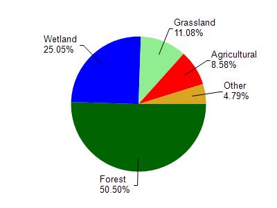
Watershed Characteristics
Mud Hen Lake is located in the Wood River watershed which is 220.24 mi². Land use in the watershed is primarily forest (50.60%), wetland (25.10%) and a mix of grassland (11.10%) and other uses (13.40%). This watershed has 197.60 stream miles, 5,461.36 lake acres and 34,321.60 wetland acres.
Nonpoint Source Characteristics
This watershed is ranked Low for runoff impacts on streams, Not Ranked for runoff impacts on lakes and Low for runoff impacts on groundwater and therefore has an overall rank of Low. This value can be used in ranking the watershed or individual waterbodies for grant funding under state and county programs.This water is ranked High Lake for individual Lakes based on runoff problems and the likelihood of success from project implementation.