Waupaca
No
No
No
Fish and Aquatic Life
Overview
Bear Lake, in the Lower Little Wolf River Watershed, is a 199.52 acre lake that falls in Waupaca County. This lake is managed for fishing and swimming and is currently not considered impaired.
Date 2011
Author Aquatic Biologist
Historical Description
Source: 1971, Surface Water Resources of Waupaca County Bear Lake, T22, 23N, R13E, Sections 4, 5, 32, 33. Surface Acres = 193.7; S.D.F. = 1.86; Maximum Depth = 67 feet.
Marl, with lesser amounts of muck and sand, is the predominant bottom material in this hard water drainage lake. Spiegleberg Creek, a small tributary to the N.Br.Little Wolf River, flows through Bear Lake. Northern pike, largemouth bass, bluegill, perch, black crappie, green sunfish, rock bass, black bullhead, white sucker, and carp constitute the fishery. A few brown or rainbow trout are also present. Aquatic vegetation is not abundant. Great blue heron and bluewing teal use the lake as a nesting area. Puddle ducks can be found during spring and fall migrations. Aquatic furbearers are scarce. Hunting is allowed with permission. Use conflicts between fishermen and pleasure boaters has led to the establishment of a water skiing and speed boating zone. Developments include one resort, one boat livery, 68 cottages, and one private campground. A public boat landing is maintained by Waupaca County on the south side of the lake. Heavy grazing causes erosion and siltation in some areas. Additional pollutants enter the lake in the form of barnyard drainage.
Date 1971
Author Surface Water Inventory Of Wisconsin
Condition
Wisconsin has over 84,000 miles of streams, 15,000 lakes and milllions of acres of wetlands. Assessing the condition of this vast amount of water is challenging. The state's water monitoring program uses a media-based, cross-program approach to analyze water condition. An updated monitoring strategy (2015-2020) is now available. Compliance with Clean Water Act fishable, swimmable standards are located in the Executive Summary of Water Condition in 2018. See also the 'monitoring and projects' tab.
Reports
Recommendations
Monitor Water Quality or Sediment
This project will evaluate water quality improvement efforts made in the Bear Lake sub-watershed of the Lower Little Wolf RIver 319 Watershed by Waupaca County LWCD and NRCS.[TWA HUC12-040302021704]. This is a Section 319 project.
Management Goals
Wisconsin's Water Quality Standards provide qualitative and quantitative goals for waters that are protective of Fishable, Swimmable conditions [Learn more]. Waters that do not meet water quality standards are considered impaired and restoration actions are planned and carried out until the water is once again fishable and swimmable
Management goals can include creation or implementation of a Total Maximum Daily Load analysis, a Nine Key Element Plan, or other restoration work, education and outreach and more. If specific recommendations exist for this water, they will be displayed below online.
Monitoring
Monitoring the condition of a river, stream, or lake includes gathering physical, chemical, biological, and habitat data. Comprehensive studies often gather all these parameters in great detail, while lighter assessment events will involve sampling physical, chemical and biological data such as macroinvertebrates. Aquatic macroinvertebrates and fish communities integrate watershed or catchment condition, providing great insight into overall ecosystem health. Chemical and habitat parameters tell researchers more about human induced problems including contaminated runoff, point source dischargers, or habitat issues that foster or limit the potential of aquatic communities to thrive in a given area. Wisconsin's Water Monitoring Strategy was recenty updated.
Grants and Management Projects
Monitoring Projects
| WBIC | Official Waterbody Name | Station ID | Station Name | Earliest Fieldwork Date | Latest Fieldwork Date | View Station | View Data |
|---|
| 279700 | Bear Lake | 10019180 | Bear Lake -- Access at S Side Of Lake Off Lake Street | 8/13/2011 | 9/1/2022 | Map | Data |
| 279700 | Bear Lake | 694009 | Bear Lake - Deepest Point | 8/1/1979 | 9/15/2022 | Map | Data |
| 279700 | Bear Lake | 693041 | Bear Lake - Deepest Point | 8/7/1980 | 9/2/2025 | Map | Data |
| 279700 | Bear Lake | 10007356 | Bear Lake | 7/27/1999 | 9/15/2022 | Map | Data |
|
Watershed Characteristics
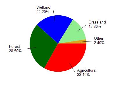
Bear Lake is located in the Lower Little Wolf River watershed which is 153.60 mi². Land use in the watershed is primarily agricultural (33.10%), forest (28.50%) and a mix of wetland (22.20%) and other uses (16.20%). This watershed has 189.20 stream miles, 1,038.51 lake acres and 21,932.16 wetland acres.
Nonpoint Source Characteristics
This watershed is ranked Medium for runoff impacts on streams, Not Ranked for runoff impacts on lakes and High for runoff impacts on groundwater and therefore has an overall rank of High. This value can be used in ranking the watershed or individual waterbodies for grant funding under state and county programs.This water is ranked High Lake for individual Lakes based on runoff problems and the likelihood of success from project implementation.