Outagamie, Shawano
No
No
Yes
Fish and Aquatic Life
Overview
Shioc River - The main stem is formed by the confluence of the West and East Branches Shioc River north of Navarino, and extends for 28 miles. The fishery of the main stem is derived from the Wolf River and is especially important during spring when walleye and bass use the river for spawning. A characteristic of the river is extreme water level fluctuations with low water and isolated pools during the summer months. The Shioc River and its tributaries flow through agricultural land with little or no buffering by vegetation. Both the Village of Bonduel and the Vlasic Foods Inc. discharge high concentrations of chlorides to the river (Masnado, 1995)
The West and East Branches of the Shioc River exhibit the same general water quality and characteristics as the main stem Shioc River.
From: Bougie, Cheryl A., Kosmond, Lisa D, and Watermolen, Dreux J. 1996. Wolf River Basin Water Quality Management Plan. Wisconsin Department of Natural Resources, Madison, WI.
Date 1996
Author Cheryl Bougie
Historical Description
Shioc River, T23N, R16E , Sec. 21(10), Area = 93.1 acres, Length = 19.2 miles, M.P.A. = 225 ppm.
The Shioc River traverses the north central portion of Outagmie County, draining into the Wolf River
just above Shiocton. The stream is characterized by extreme water level fluctuations, ranging from above an
established gauge to below the gauge in less than a month. The stream is generally slow moving
and turbid. Stream bottom materials consist mostly of silt with a few sand and gravel areas. Instream cover
is present but not overly abundant. Caddisflies, shrimp, and crayfish are common. The Shioc River is fished
heavily in the spring during the annual walleye and white bass runs. Road crossings are usually choked with
fishermen at this time. The remainder of the fishery is largely derived from the Wolf River. Two State,
two county, and three town roads provide public access.
From: Nelson, Linden M. and Ronald L. Fassbender. Surface Water Resources of Outagamie County:
Lake and Stream Classification Project. Wisconsin Department of Natural Resources, Madison, WI.
Date 1972
Author Surface Water Inventory Of Wisconsin
Impaired Waters
Shioc River (316800) was placed on the impaired waters list for total phosphorus in 2012. The 2016 assessments showed continued impairment by phosphorus; total phosphorus sample data overwhelmingly exceeded 2016 WisCALM listing thresholds for the Fish and Aquatic Life use, however, available biological data do not indicate impairment (i.e. no macroinvertebrate or fish Index of Biotic Integrity (IBI) scored in the "poor" condition category). Based on the most updated information, no change in existing impaired waters listing is needed.
Date 2015
Author Aaron Larson
Condition
Wisconsin has over 84,000 miles of streams, 15,000 lakes and milllions of acres of wetlands. Assessing the condition of this vast amount of water is challenging. The state's water monitoring program uses a media-based, cross-program approach to analyze water condition. An updated monitoring strategy (2015-2020) is now available. Compliance with Clean Water Act fishable, swimmable standards are located in the Executive Summary of Water Condition in 2018. See also the 'monitoring and projects' tab.
Reports
Recommendations
Restore Wetlands
Restore Wetlands
Restore Wetlands
Restore Wetlands
Restore Wetlands
Restore Wetlands
Restore Wetlands
Restore Wetlands
Navigability Determination
; Shiocton River; Extension of previous determination
Management Goals
Wisconsin's Water Quality Standards provide qualitative and quantitative goals for waters that are protective of Fishable, Swimmable conditions [Learn more]. Waters that do not meet water quality standards are considered impaired and restoration actions are planned and carried out until the water is once again fishable and swimmable
Management goals can include creation or implementation of a Total Maximum Daily Load analysis, a Nine Key Element Plan, or other restoration work, education and outreach and more. If specific recommendations exist for this water, they will be displayed below online.
Monitoring
Monitoring the condition of a river, stream, or lake includes gathering physical, chemical, biological, and habitat data. Comprehensive studies often gather all these parameters in great detail, while lighter assessment events will involve sampling physical, chemical and biological data such as macroinvertebrates. Aquatic macroinvertebrates and fish communities integrate watershed or catchment condition, providing great insight into overall ecosystem health. Chemical and habitat parameters tell researchers more about human induced problems including contaminated runoff, point source dischargers, or habitat issues that foster or limit the potential of aquatic communities to thrive in a given area. Wisconsin's Water Monitoring Strategy was recenty updated.
Grants and Management Projects
Monitoring Projects
| WBIC | Official Waterbody Name | Station ID | Station Name | Earliest Fieldwork Date | Latest Fieldwork Date | View Station | View Data |
|---|
| 316800 | Shioc River | 453030 | Shioc River at Sth 187 Bridge | 1/14/1975 | 10/20/2025 | Map | Data |
| 316800 | Shioc River | 10032723 | Shioc River below Black Creek mouth | | | Map | Data |
| 316800 | Shioc River | 453280 | Shioc River at Sth 168 (Cth F) | 5/24/1979 | 11/7/1979 | Map | Data |
| 316800 | Shioc River | 10037809 | Shioc River Upstream of Nichols WWTF | 7/17/2012 | 10/18/2012 | Map | Data |
| 316800 | Shioc River | 10020743 | Shioc River-Along Scott Rd Below Nichols | | | Map | Data |
| 316800 | Shioc River | 453257 | Shioc River - County Highway P | 6/5/1979 | 10/30/1997 | Map | Data |
| 316800 | Shioc River | 10055971 | Shioc River DS Newland Rd | | | Map | Data |
|
Watershed Characteristics
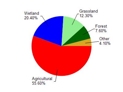
Shioc River is located in the Shioc River watershed which is 189.76 mi². Land use in the watershed is primarily agricultural (55.60%), wetland (20.40%) and a mix of grassland (12.30%) and other uses (11.70%). This watershed has 375.85 stream miles, 323.09 lake acres and 23,354.20 wetland acres.
Nonpoint Source Characteristics
This watershed is ranked High for runoff impacts on streams, Not Ranked for runoff impacts on lakes and High for runoff impacts on groundwater and therefore has an overall rank of High. This value can be used in ranking the watershed or individual waterbodies for grant funding under state and county programs.However, all waters are affected by diffuse pollutant sources regardless of initial water quality. Applications for specific runoff projects under state or county grant programs may be pursued. For more information, go to surface water program grants.