Rock
No
Yes
No
Fish and Aquatic Life
Overview
The Raccoon Creek sub-watershed covers the Town of Newark and the western portion of the Town of Beloit in the Lower Sugar River Watershed of the Sugar-Pecatonica River Basin in southwestern Rock County, Wisconsin. Raccoon Creek is roughly 15 miles long and is comprised of two main spring-fed branches. East Fork Raccoon Creek begins in the Town of Beloit while the western fork, known only as Raccoon Creek, begins in the Town of Newark. For the purposes of this report, East Fork and West Fork will be used. These two forks of Raccoon Creek flow south into Winnebago County, Illinois where they join and then flow to the Pecatonica River .
The two major soil types in the Wisconsin portion of the watershed are the Edmund-Rockton-Whalan associations, located in the headwaters of Raccoon Creek, and the Colwood-Sebewa association, found near the state line. The Edmund-Rockton-Whalan soils are moderately deep and well-drained while the Colwood-Sebewa association is a moderately deep or deep, poorly drained soil with a clay loam subsoil over stratified silt and fine sand and gravel outwash deposits. Weathered and eroded sand, blown over from the Sugar River flood plain has added a noticeable sand content to the soils in the towns of Newark and Beloit. The surface topography of the area consists of differentially eroded bedrock in the Town of Newark and outwash plain in the Town of Beloit and is mostly characterized by deep valleys cut into sandstone (USDA, 1974).
Raccoon Creek is located in the Southeastern Ridges and Lowlands Ecoregion of Wisconsin (Sample and Mossman, 1997). (I’m not sure which ecoregion designations you used in the remainder of the report - but perhaps we need to make them consistent between the different sections.) Prior to settlement in this small watershed, vegetative communities contained a diverse mix ranging from deciduous forest and oak savanna to prairies, oak openings, sedge meadows and marshes, with a mosaic of prairies and wetlands. Although Raccoon Creek is located close to the City of Beloit, limited development has occurred in the watershed. The total population of Beloit and Newark Townships, based upon Census 2000 data, are 7,038 and 1,571 respectively (DOA, 2001). Today, most of the land in this watershed has been converted for agricultural land use. Therefore, the main source of stream degradation results from agricultural nonpoint source pollution and not traditional urban land uses. The Wisconsin DNR and the Rock County Land Conservation Department have identified the Raccoon Creek Watershed as a high priority for nonpoint source pollution abatement through the reduction of the volume of runoff that enters the creek (Rock County LCD, 1998).
Despite problems with nonpoint source pollution, the East Fork and West Fork of Raccoon Creek are 2 of the 8 creeks in Rock County designated as Exceptional Resource Waters (ERW). This designation is reserved for surface waters that are not significantly impacted by human activities, and that also provide valuable fisheries, contain unique environmental features or provide an outstanding recreational opportunity. Raccoon Creek and its watershed provide habitat for a variety of rare aquatic and terrestrial plants and animals. In addition, there are several unique environmental features in the watershed including some good quality wetlands and prairies.
Date 2002
Author Aquatic Biologist
Historical Description
From: Ball, Joseph R., and Ronald J. Poff, Lake and Stream Classification Project. Surface Water Resources of Rock County, Department of Natural Resources, 1970.
Surface Acres = 14.67, Miles 9.1, Gradient = 11 feet per mile.
A spring fed stream flowing through the Town of Newark into Illinois. Raccoon Creek was managed for trout up to 1955 when high water temperatures and considerable posting made it impractical to continue stocking. The present fish population consists of carp, suckers and forage species. The stream is impounded near the Illinois border to form a shallow Mill Pond. There are 746 acres of adjoining wetland, 20 percent of which is tamarack swamp. About one-third mile of the stream borders a 75.2 acre public hunting grounds which is stocked with pheasants. The stream's adjoining wetland does receive some use by migrating waterfowl and hunting is allowed. Access is available from six town roads and one state highway.
Date 1970
Author Surface Water Inventory Of Wisconsin
General Condition
Raccoon Creek was assessed during the 2018 listing cycle; new biological (macroinvertebrate and fish Index of Biotic Integrity (IBI) scores) and temperature sample data were clearly below the 2018 WisCALM listing thresholds for the Fish and Aquatic Life use. This water was meeting this designated use and was not considered impaired.
Date 2017
Author Ashley Beranek
Condition
Wisconsin has over 84,000 miles of streams, 15,000 lakes and milllions of acres of wetlands. Assessing the condition of this vast amount of water is challenging. The state's water monitoring program uses a media-based, cross-program approach to analyze water condition. An updated monitoring strategy (2015-2020) is now available. Compliance with Clean Water Act fishable, swimmable standards are located in the Executive Summary of Water Condition in 2018. See also the 'monitoring and projects' tab.
Reports
Recommendations
Citizen-Based Stream Monitoring
Collect chemical, physical, and/or biological water quality data to assess the current overall stream health. The data can inform management decisions and may be used to identify impaired waters for biennial lists.
Fish Management, Access
The Friends of Beckman Mill, Inc. will construct a natural looking fish passageway that will protect the threatened and endangered species found in the stream. The fish passageway will also increase public awarenes about fish behavior and solutions to fish migration around obstructions.
Conduct Survey of Residents
The Rock County Land Conservation Department will create a Citizen's Advisory Committee, develop a plan of action for water quality issues and begin its implementation, and disseminate information to the general citizenry of the watershed.
Fish Management, Access
The Friends of Beckman Mill- Inc. will construct a natural looking fish passageway that will protect the threatened and endangered species found in the stream. The fish passageway will also increase public awarenes about fish behavior and solutions to fish migration around obstructions. A full description of project scope and deliverables is available in the grant application- which is part of this agreement. The DNR will be provided with both a paper copy and an electronic copy of the final report. Information will be disseminated to the public as described in the grant application.
Management Goals
Wisconsin's Water Quality Standards provide qualitative and quantitative goals for waters that are protective of Fishable, Swimmable conditions [Learn more]. Waters that do not meet water quality standards are considered impaired and restoration actions are planned and carried out until the water is once again fishable and swimmable
Management goals can include creation or implementation of a Total Maximum Daily Load analysis, a Nine Key Element Plan, or other restoration work, education and outreach and more. If specific recommendations exist for this water, they will be displayed below online.
Monitoring
Monitoring the condition of a river, stream, or lake includes gathering physical, chemical, biological, and habitat data. Comprehensive studies often gather all these parameters in great detail, while lighter assessment events will involve sampling physical, chemical and biological data such as macroinvertebrates. Aquatic macroinvertebrates and fish communities integrate watershed or catchment condition, providing great insight into overall ecosystem health. Chemical and habitat parameters tell researchers more about human induced problems including contaminated runoff, point source dischargers, or habitat issues that foster or limit the potential of aquatic communities to thrive in a given area. Wisconsin's Water Monitoring Strategy was recenty updated.
Grants and Management Projects
Monitoring Projects
| WBIC | Official Waterbody Name | Station ID | Station Name | Earliest Fieldwork Date | Latest Fieldwork Date | View Station | View Data |
|---|
| 874000 | Raccoon Creek | 10031035 | Beckman Mill Pond (Raccoon Creek) County Park Canoe Launch | 5/25/2010 | 6/22/2026 | Map | Data |
| 874000 | Raccoon Creek | 10016301 | Raccoon Creek - Skinner Rd Crossing | 5/23/1994 | 5/23/1994 | Map | Data |
| 874000 | Raccoon Creek | 10012056 | Raccoon Cr - US of Cleophas Rd | 10/28/1987 | 5/23/1994 | Map | Data |
| 874000 | Raccoon Creek | 10013075 | Raccoon Creek - Hwy 81 Bridge | 10/28/1987 | 9/15/2025 | Map | Data |
| 874000 | Raccoon Creek | 10013074 | Raccoon Creek - Upstream Of Cth 'H' Bridge | 10/28/1987 | 9/29/2011 | Map | Data |
| 874000 | Raccoon Creek | 10012055 | Raccoon Creek at Beloit Newark Rd | 10/29/2004 | 1/1/2015 | Map | Data |
| 874720 | Beckmans Millpond | 10037647 | Beckman Millpond | | | Map | Data |
| 874000 | Raccoon Creek | 10039503 | West Fork Raccoon Creek at Beckman Mill 50yds downstream of dam | | | Map | Data |
| 874000 | Raccoon Creek | 10053382 | Raccoon Creek at Luther Valley Rd | | | Map | Data |
| 874000 | Raccoon Creek | 10016373 | Raccoon Creek - St Lawrence Rd | 5/23/1994 | 9/28/2015 | Map | Data |
|
Watershed Characteristics
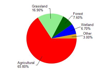
Raccoon Creek is located in the Lower Sugar River watershed which is 217.85 mi². Land use in the watershed is primarily agricultural (65.80%), grassland (16.90%) and a mix of forest (7.60%) and other uses (9.70%). This watershed has 467.98 stream miles, 202.10 lake acres and 6,999.03 wetland acres.
Nonpoint Source Characteristics
This watershed is ranked Low for runoff impacts on streams, Not Ranked for runoff impacts on lakes and High for runoff impacts on groundwater and therefore has an overall rank of High. This value can be used in ranking the watershed or individual waterbodies for grant funding under state and county programs.This water is ranked High Stream for individual Rivers based on runoff problems and the likelihood of success from project implementation.