Iowa, Lafayette
Yes
No
No
Fish and Aquatic Life
Overview
Cannon Creek, in the Yellowstone River Watershed, is a 7.67 mile river that falls in Iowa and Lafayette Counties. This river is a Class II Trout Water under the Fisheries Program. This river is managed for fishing and swimming and is currently not considered impaired.
Date 2011
Author Aquatic Biologist
Historical Description
Canon Creek - Outlet location T4N R4E Section 17 -15, Gradient = 38.9 feet per mile, Surface acres = 1.9, Length = 1.9 miles, Total alkalinity = 302 mg/l, Volume of flow = 0.6 cfs.
Cannon Creek is one of the Yellowstone Lake's major tributaries and enters it about 1.5 miles above Yellowstone Lake in Lafayette County. It is spring fed and is managed for trout and smallmouth bass for about the upper two-thirds of its length. The principal land use in the watershed is beef cattle grazing and agricultural crops. Only about 18 percent is in
woodlands.
Waterfowl and marshland furbearers can be considered scarce due to the well drained nature of the watershed. The sport fishery consists of brown trout which are stocked annually.
A seining survey showed that a variety of forage fishes also exist in this stream. Species found to be present include hornyhead and creek chubs, stoneroller and bluntnose minnows, common shiners, johnny and fantail darters and redbelly dace. There is no public frontage on the stream and it is accessible from only one town road bridge.
From: Piening, Ronald and Threinen, C.W., Lake and Stream Classification Project. Surface Water Resources of Iowa County, Department of Natural Resources, 1968.
Date 1968
Author Surface Water Inventory Of Wisconsin
Historical Description
Canon Creek (Canon Branch), T4N, R4E, Sections 26-11, Surface acres = 4.3, Miles = 4.3, Gradient = 28.6 feet per mile, Total alkalinity = 254 ppm., Volume of flow = 1.9 cfs.
Canon Creek is a spring-fed tributary of the Yellowstone River. It enters the Yellowstone River about 1.5 miles above Yellowstone Lake. Although it is spring-fed, it is considered a marginal trout stream. Smallmouth bass are also present. It is stocked with brown trout annually and stocking is restricted tothe upper two-thirds of its length. The stream banks exhibit light to moderate erosion. The stream bed is gravel in the upper portions and silt in the lower portions. Areas in the vicinity of the Yellowstone River provide good habitatfor muskrats and waterfowl while the watershed in general contains deer, squirrels, rabbits, pheasants, ruffed grouse, and Hungarian partridge. Most of the land in the watershed is under cultivation. Public ownership is nonexistent along this stream. Accessibility is possible from one county and three town road bridges.
From: Piening, Ronald; Poff, Ronald; Threinen, C.W., 1967. Lake and Stream Classification Project. Surface Water Resources of Lafayette County, Wisconsin Department of Natural Resources, Madison, WI.
Date 1967
Author Surface Water Inventory Of Wisconsin
General Condition
Cannon Creek (WBIC 904500) was assessed during the 2018 listing cycle; new biological (fish Index of Biotic Integrity (IBI) scores) sample data were clearly below the 2018 WisCALM listing thresholds for the Fish and Aquatic Life use. This water was meeting this designated use and was not considered impaired.
Date 2017
Author Ashley Beranek
Condition
Wisconsin has over 84,000 miles of streams, 15,000 lakes and milllions of acres of wetlands. Assessing the condition of this vast amount of water is challenging. The state's water monitoring program uses a media-based, cross-program approach to analyze water condition. An updated monitoring strategy (2015-2020) is now available. Compliance with Clean Water Act fishable, swimmable standards are located in the Executive Summary of Water Condition in 2018. See also the 'monitoring and projects' tab.
Reports
Management Goals
Wisconsin's Water Quality Standards provide qualitative and quantitative goals for waters that are protective of Fishable, Swimmable conditions [Learn more]. Waters that do not meet water quality standards are considered impaired and restoration actions are planned and carried out until the water is once again fishable and swimmable
Management goals can include creation or implementation of a Total Maximum Daily Load analysis, a Nine Key Element Plan, or other restoration work, education and outreach and more. If specific recommendations exist for this water, they will be displayed below online.
Monitoring
Monitoring the condition of a river, stream, or lake includes gathering physical, chemical, biological, and habitat data. Comprehensive studies often gather all these parameters in great detail, while lighter assessment events will involve sampling physical, chemical and biological data such as macroinvertebrates. Aquatic macroinvertebrates and fish communities integrate watershed or catchment condition, providing great insight into overall ecosystem health. Chemical and habitat parameters tell researchers more about human induced problems including contaminated runoff, point source dischargers, or habitat issues that foster or limit the potential of aquatic communities to thrive in a given area. Wisconsin's Water Monitoring Strategy was recenty updated.
Grants and Management Projects
Monitoring Projects
| WBIC | Official Waterbody Name | Station ID | Station Name | Earliest Fieldwork Date | Latest Fieldwork Date | View Station | View Data |
|---|
| 904500 | Canon Creek | 10009270 | Canon Creek Station 1 | 11/15/2002 | 7/10/2012 | Map | Data |
| 904500 | Canon Creek | 10012829 | Canon Branch Easement | | | Map | Data |
| 904500 | Canon Creek | 10037525 | Canon Creek at English Hollow Rd (upper crossing) | 1/1/2015 | 1/1/2015 | Map | Data |
| 904500 | Canon Creek | 10044969 | Canon Creek at Rock Branch Rd | 6/2/2016 | 6/2/2016 | Map | Data |
| 904500 | Canon Creek | 10037527 | Canon Creek at CTY S | 7/10/2016 | 7/10/2016 | Map | Data |
| 904500 | Canon Creek | 10012841 | Canon Creek Gilberston Road | 1/1/2015 | 10/10/2016 | Map | Data |
|
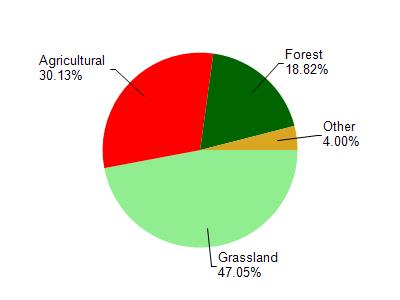
Watershed Characteristics
Canon Creek is located in the Yellowstone River watershed which is 57.46 mi². Land use in the watershed is primarily grassland (47%), agricultural (30.10%) and a mix of forest (18.80%) and other uses (4.00%). This watershed has 158.93 stream miles, 9.53 lake acres and 636.16 wetland acres.
Nonpoint Source Characteristics
This watershed is ranked High for runoff impacts on streams, Medium for runoff impacts on lakes and High for runoff impacts on groundwater and therefore has an overall rank of High. This value can be used in ranking the watershed or individual waterbodies for grant funding under state and county programs.However, all waters are affected by diffuse pollutant sources regardless of initial water quality. Applications for specific runoff projects under state or county grant programs may be pursued. For more information, go to surface water program grants.