Ozaukee
No
No
Yes
Fish and Aquatic Life
Overview
Fredonia Creek, in the Milwaukee River South Watershed, is a 4.11 mile river that falls in Ozaukee County. This river is managed for fishing and swimming and is currently considered impaired.
Date 2022
Author Ashley Beranek
Historical Description
The Fredonia subwatershed is comprised of one perennial and three intermittent streams in the
northeastern portion of the watershed.
Water Resources - The only perennial surface water in this subwatershed, referred to
here as Fredonia Creek, is approximately 4.2 miles long from its headwaters to its mouth at the
Milwaukee River in the village of Fredonia in Waubedonia Park. Most of the stream length
has been channelized to accommodate agricultural and urban drainage. All three intermittent
tributaries, which combined stretch approximately 3.0 miles, have been channelized for drainage
purposes.
Observed in-stream habitat and water quality of Fredonia Creek is generally considered "fair" to
"poor", that of the three tributaries "poor". The existing status of the fishery source supports
this conclusion. The fish community is dominated by species tolerant to very tolerant of
degraded habitat and water quality. Sedimentation from upland and streambank erosion,
channelization, draining of wetlands, and urban runoff from the village of Fredonia negatively
alter water quality and habitat in Fredonia Creek and its tributaries. Reducing sedimentation
rates, prohibiting draining of wetlands and channelization of streams, and reducing runoff rates
from urban and rural land uses would enhance designated fish and wildlife habitat, and improve
water quality. The presence of a limited population of northern pike and juvenile smallmouth
bass suggest that these species may utilize Fredonia Creek as spawning and nursery habitat.
Wetlands and native-vegetated corridors along the tributaries of Fredonia Creek provide
valuable habitat for wildlife and fish communities.
Adjacent to the Peterson Company in the village of Fredonia is one of the three small
tributaries and a wetland area not located on a USGS topographic map (T12N R21E9Sec.35, SE
of NW quarter). This wetland parcel appears to have been filled with unknown fill material.
Industrial "dust" and slag-like material have been observed next to the tributary and a mixture of
cloudy gray and orange-stained leachate discharges were detected in the stream. No chemical
data for this stream reach are available at this time.
Because of its limited size and depth, Fredonia Creek and the three tributaries are classified as
supporting only "partial-body contact" forms of recreation.
Fisheries - This subwatershed consists of two intermittent tributaries to the mainstem of the
Milwaukee River. Both enter the river in the vicinity of Waubedonia Park, the larger flowing
south and east through the village of Fredonia. Neither of these streams is actively managed as
a sport fishery, but do provide nursery areas for juvenile smallmouth bass and northern pike.
Upper reaches of the larger tributary may also provide important spawning areas for northern
pike, but have been dredged to facilitate agricultural drainage. Other factors limiting the fishery
potential of these two small streams include dredging and vegetation removal to facilitate
residential development, siltation, unstable flows, impounding, and small size.
Wildlife - In general, wildlife habitat associated with stream corridors is good-- 50 percent is
forested and 21 percent is composed of shrub and emergent wetland cover types. However, in
the case of terrestrial wildlife, habitat is limited since 21 percent of the riparian area is cropped.
Scattered wetlands and swamp hardwoods occur throughout the watershed. State or federal
wildlife properties exist within the watershed. Farmed wetlands and highly erodible lands may
qualify for ently into the ansewation R e m e Program (CRP). Restorable wetlands exist,
though currently drained by ditches or tile. Approximately 13 acres of cropped riparian areas
are also eligible as GRP filter strips. Greater attention must be directed at protecting remaining
wetlands,
Date 1992
Author Surface Water Inventory Of Wisconsin
Historical Description
Parks - There are no county, state, or privately-owned park and recreation sites located in this
subwatershed. There are, however, four community-owned sites in the village of Frdonia
encompassing a tdtal of 12 acres. In addition, there are small segments of environmental
corridor lands, identified by the Southeastern Wisconsin Regional Planning Commission,
PC) located along the mainstem of the Milwaukee River in this subwatershed. All of
the recreational lands are located in the southern portion of the subwatershed.
- The primary timber types are Northern Har on the uplands and Swamp
s (silver maple, elm, ash) on the lowlands adjacent to many of the waterways. There
is a small percentage of planted conifer on scattered areas of farmland.
Two parcels of woods totaling 93 acres are enrolled in the Forest Tax laws. Logging is
prevalent in the upland timber types and is primarily selective. Harvesting of the lowland type
in many cases is heavier than harvesting of the upland
At present, there are no CRP enrollees (tree planting only) in this watershed. Timber stand
improvement within the watershed is minimal. However, some individual landowners cut
firewood and privately make improvement cuts on their own. Indiscriminate and generally heavy
harvesting of sawlogs by logging companies is common.
Many acres of erodible land need to be removed from permanent production and instead
seeded with either trees or grass.
- mis watenhd baa;: Wo b o w abandoned landfills-- Peterson
Industries, Inc. and the town of Fredonia. Potential problems associated with the Peterson
Company are discussed in the Water Resources narrative. The town of Fredonia's abandoned
landfill may pose a threat to future water quality but little information is available at this time.
Long-range solid waste planning will safeguard surface and groundwater resources within this
subwatershed.
The village of Fredonia plans to implement a mandatory curbside recycling program.
- The village of Fredonia is served by a municipal water system. The Village
has adopted a private well abandonment ordinance to prevent unused or improperly constructed
wells from conveying contaminated surface or near-surface waters to the usable groundwater.
Currently this subwatershed has no community wells. The remainder of the area is served by
private wells.
Date 1992
Author Surface Water Inventory Of Wisconsin
Historical Description
- Regular program activities ur on a case-by-case basis and
are in response to actions or requesb from individuals. These activities include protection of
wetlands through oversight of county wetland/shoreland ordinances and incorporation of
watershed objectives into projects requiring water regulation permits. Additional program
responsibilities include review and response to the Federal Clean Water Act, Section 404
applications to fill small wetlands.
Wastewater - The village of Fredonia is served by a municipal wastewater treatment plant,
regulated by the Department Wastewater Program and described in detail with recommendations
in Section C, the Point Source Report. Information on industrial wastewater discharges is also '
found in Section C. Although physically located in the Fredonia subwatershed, this facility
directly discharges to the Milwaukee River in the Waubeka subwatershed. Refer to the
Waubeka subwatershed narrative for discussion of management recommendations for this facility.
The Ozaukee County Sanitarian is responsible for on-site private wastewater management in this
drainage way.
Nonwint Source - The lower reach of Fredonia Creek, within the village of Frdonia, receives
63 percent of its sediment load from rural upland erosion, 24 percent from rural streambank
erosion, and 12 percent from existing urban areas. It is anticipated that the urban area in the
subwatershed will double, primarily because of urbanization within the Fredonia Village limits.
The village of Fredonia has no construction erosion control ordinance or program to limit this
pollution potential. Although information concerning toxic impacts on the Creek has not been
collected, it is known that Fredonia Creek has an annual lead load of 135 pounds in addition to
other urban toxicants. Sources of animal waste pollution occur in the subwatershed, but are not
widespread.
Date 1992
Author Surface Water Inventory Of Wisconsin
Impaired Waters
Fredonia Creek was evaluated for phosphorus every two-year cycle from 2014 to 2022 and levels were too high for healthy aquatic communities like plants, bugs, and fish. A phosphorus listing was added to the Impaired Waters List in 2014 and was confirmed in subsequent cycles.
Date 2022
Author Ashley Beranek
Condition
Wisconsin has over 84,000 miles of streams, 15,000 lakes and milllions of acres of wetlands. Assessing the condition of this vast amount of water is challenging. The state's water monitoring program uses a media-based, cross-program approach to analyze water condition. An updated monitoring strategy (2015-2020) is now available. Compliance with Clean Water Act fishable, swimmable standards are located in the Executive Summary of Water Condition in 2018. See also the 'monitoring and projects' tab.
Reports
Recommendations
Citizen-Based Stream Monitoring
Collect chemical, physical, and/or biological water quality data to assess the current overall stream health. The data can inform management decisions and may be used to identify impaired waters for biennial lists.
Restore Wetlands
Restore Wetlands
Management Goals
Wisconsin's Water Quality Standards provide qualitative and quantitative goals for waters that are protective of Fishable, Swimmable conditions [Learn more]. Waters that do not meet water quality standards are considered impaired and restoration actions are planned and carried out until the water is once again fishable and swimmable
Management goals can include creation or implementation of a Total Maximum Daily Load analysis, a Nine Key Element Plan, or other restoration work, education and outreach and more. If specific recommendations exist for this water, they will be displayed below online.
Monitoring
Monitoring the condition of a river, stream, or lake includes gathering physical, chemical, biological, and habitat data. Comprehensive studies often gather all these parameters in great detail, while lighter assessment events will involve sampling physical, chemical and biological data such as macroinvertebrates. Aquatic macroinvertebrates and fish communities integrate watershed or catchment condition, providing great insight into overall ecosystem health. Chemical and habitat parameters tell researchers more about human induced problems including contaminated runoff, point source dischargers, or habitat issues that foster or limit the potential of aquatic communities to thrive in a given area. Wisconsin's Water Monitoring Strategy was recenty updated.
Grants and Management Projects
Monitoring Projects
| WBIC | Official Waterbody Name | Station ID | Station Name | Earliest Fieldwork Date | Latest Fieldwork Date | View Station | View Data |
|---|
| 26600 | Unnamed | 10016208 | Fredonia #41 - 120 M Ds Cth A | 9/30/1999 | 9/30/1999 | Map | Data |
| 15000 | Milwaukee River | 463005 | Milwaukee River - Fredonia Stp | 2/28/1978 | 4/6/1978 | Map | Data |
| 26600 | Unnamed | 10031395 | Fredonia Creek near intersection with Milwaukee River | 5/13/2010 | 5/31/2021 | Map | Data |
| 26600 | Unnamed | 10039638 | Unnamed Trib (Fredonia Creek) at Wenzel Ave | 6/4/2011 | 10/25/2025 | Map | Data |
| 26600 | Unnamed | 10016256 | Fredonia Cr - Downstream Cth A | 9/23/1998 | 9/23/1998 | Map | Data |
| 26600 | Unnamed | 10016207 | Fredonia #41 - 120 M Ds Cth A | 9/30/1999 | 9/30/1999 | Map | Data |
| 26600 | Unnamed | 10016592 | Stoney Creek - Downstream Of 1st Railroad Xingemmer Road Extended Fd 005do Sat = 94% | 5/14/1992 | 5/14/1992 | Map | Data |
|
Watershed Characteristics
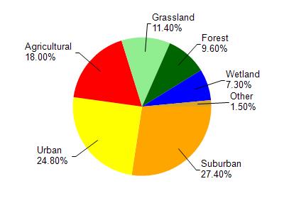
Unnamed is located in the Milwaukee River South watershed which is 167.90 mi². Land use in the watershed is primarily suburban (27.40%), urban (24.80%) and a mix of agricultural (18%) and other uses (29.80%). This watershed has 203.63 stream miles, 13,038.94 lake acres and 5,996.03 wetland acres.
Nonpoint Source Characteristics
This watershed is ranked High for runoff impacts on streams, High for runoff impacts on lakes and High for runoff impacts on groundwater and therefore has an overall rank of High. This value can be used in ranking the watershed or individual waterbodies for grant funding under state and county programs.However, all waters are affected by diffuse pollutant sources regardless of initial water quality. Applications for specific runoff projects under state or county grant programs may be pursued. For more information, go to surface water program grants.