Walworth
No
No
No
Fish and Aquatic Life
Overview
White River flows from the outlet of Lake Geneva for 23 miles before discharging to the Fox River north of Burlington. The general condition of the stream is known to exceed total phosphorus standards (clearly exceeds), and the water has the attainable use of a Warm Water Sport Fishery. Biological data collected may indicate micro-system conditions of "good". However, the timing, location and habitat collected influence the aquatic community found. This stream is part of a larger system with excess total phosphorus. Based on site specific information, this segment is on DNR's impaired waters list.
Date 2015
Author Lisa Helmuth
General Condition
The White River was evaluated for phosphorus and biology in 2020. Phosphorus values were clearly below criteria (did not exceed WQ standards), indicating this water can be delisted from the impaired waters list in the 2020 cycle.
Previous condition assessments of the White River (mile 3 to headwaters) indicated that biological resources (macroinvertebrates and fish Index of Biotic Integrity (IBI) values were NOT "poor", but instead indicated good or fair. (LDK)
Date 2019
Author Ashley Beranek
General Condition
White River flows from the outlet of Lake Geneva for 23 miles before discharging to the Fox River north of Burlington. The general condition of the stream is known to exceed total phosphorus standards (clearly exceeds), and the water has the attainable use of a Warm Water Sport Fishery. At station 653111, White River at Sth 36 (Bi Sur), there were six exceedances of the water quality threshold of 75 mg/L. The median value was 136.0 mg/L with a range of 90.0 mg/l to 280.0 mg/L in the six samples over a 10 year period.
Date 2011
Author Aquatic Biologist
Impaired Waters
White River (751200) from just west of Bloomfield Creek to Fox River was placed on the impaired waters list for total phosphorus in 2012. The 2016 assessments showed continued impairment by phosphorus; total phosphorus sample data exceeded 2016 WisCALM listing criteria for the Fish and Aquatic Life use, however, available biological data did not indicate impairment (i.e. no macroinvertebrate or fish Index of Biotic Integrity (IBI) scored in the "poor" condition category). Based on the most updated information, no change in existing impaired waters listing is needed.
Date 2015
Author Aaron Larson
Impaired Waters
This water was assessed during the 2012 listing cycle, and total phosphorus sample data exceed 2012 WisCALM listing criteria for the fish and aquatic life use; however, available biological data do not indicate impairment (i.e. no macroinvertebrate or fish Index of Biotic Integrity (IBI) scored in the "poor" condition category). This stream segment was reassessed during the 2012 assessment cycle using data from 2001-2010 and revised assessment methodology (draft 2014 WisCALM). Using this methodology, total phosphorus data exceed criteria for the Fish and Aquatic Life use; however, available biological data do not indicate impairment. This water was assessed during the 2014 listing cycle; total phosphorus sample data exceed 2014 WisCALM listing criteria for the Fish and Aquatic Life use, however, available biological data do not indicate impairment (i.e. no macroinvertebrate or fish Index of Biotic Integrity (IBI) scored in the "poor" condition category).
Date 2014
Author Lisa Helmuth
Aquatic Invasives
Biological results (mIBI) from the last 10 years indicate macroinvertebrate communities sampled up to 2012 did not show biological impairment. This does not indicate that the water quality standards are met for all parameters, however.
Date 2014
Author Lisa Helmuth
Condition
Wisconsin has over 84,000 miles of streams, 15,000 lakes and milllions of acres of wetlands. Assessing the condition of this vast amount of water is challenging. The state's water monitoring program uses a media-based, cross-program approach to analyze water condition. An updated monitoring strategy (2015-2020) is now available. Compliance with Clean Water Act fishable, swimmable standards are located in the Executive Summary of Water Condition in 2018. See also the 'monitoring and projects' tab.
Reports
Recommendations
Runoff Grant - Targeted Runoff Urban
CITY OF BURLINGTON: White River Streambank Stabilization
Restore Wetlands
Restore Wetlands
Restore Wetlands
Restore Wetlands
Monitor Water Quality or Sediment
extensive flooding near Burlington in 2017, took many months for floodwaters to receded. Need data during a normal water year.
Rivers Planning Grant
LPL-792 Town of Linn 2020 Comprehensive Plan
Management Goals
Wisconsin's Water Quality Standards provide qualitative and quantitative goals for waters that are protective of Fishable, Swimmable conditions [Learn more]. Waters that do not meet water quality standards are considered impaired and restoration actions are planned and carried out until the water is once again fishable and swimmable
Management goals can include creation or implementation of a Total Maximum Daily Load analysis, a Nine Key Element Plan, or other restoration work, education and outreach and more. If specific recommendations exist for this water, they will be displayed below online.
Monitoring
Monitoring the condition of a river, stream, or lake includes gathering physical, chemical, biological, and habitat data. Comprehensive studies often gather all these parameters in great detail, while lighter assessment events will involve sampling physical, chemical and biological data such as macroinvertebrates. Aquatic macroinvertebrates and fish communities integrate watershed or catchment condition, providing great insight into overall ecosystem health. Chemical and habitat parameters tell researchers more about human induced problems including contaminated runoff, point source dischargers, or habitat issues that foster or limit the potential of aquatic communities to thrive in a given area. Wisconsin's Water Monitoring Strategy was recenty updated.
Grants and Management Projects
Monitoring Projects
| WBIC | Official Waterbody Name | Station ID | Station Name | Earliest Fieldwork Date | Latest Fieldwork Date | View Station | View Data |
|---|
| 751200 | White River | 653267 | White River - Center St 055451345 | 11/18/1998 | 3/5/2024 | Map | Data |
| 751200 | White River | 10043884 | White River Downstream of Grand Geneva Way | 1/1/2015 | 1/1/2015 | Map | Data |
| 751200 | White River | 10051692 | White River 250 m DS STH 50 | 10/15/2018 | 3/12/2021 | Map | Data |
| 751200 | White River | 10032449 | White River at Lake Geneva | | | Map | Data |
|
Projects
White River had a NPS grant implemented directly downstream of the Echo Lake dam and relatively flat from bank to bank. During more rare flooding events, much of the general area could be under water. Challenges occurred in design and construction to define the ordinary high water mark and effectively install fabric and rip rap to protect the eroding area. A typical riverbank cross section did not apply in this situation. Through field supervision and working in conjunction with WDNR representatives, the project managers successfully completed the project to reduce the potential erosion in the river.
The grant was designed to design and install stream bank protection practices along Echo Lake and the White River to remediate erosion and sedimentation, provide a runoff buffer, and improve habitat.
Date 2014
Author Runoff Program
Watershed Characteristics
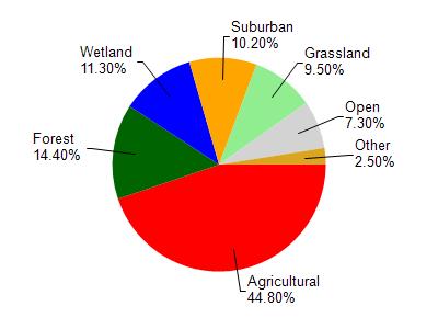
White River is located in the White River and Nippersink Creek watershed which is 168.35 mi². Land use in the watershed is primarily agricultural (44.80%), forest (14.40%) and a mix of wetland (11.30%) and other uses (29.50%). This watershed has 239.00 stream miles, 8,603.24 lake acres and 10,838.84 wetland acres.
Nonpoint Source Characteristics
This watershed is ranked High for runoff impacts on streams, Medium for runoff impacts on lakes and High for runoff impacts on groundwater and therefore has an overall rank of High. This value can be used in ranking the watershed or individual waterbodies for grant funding under state and county programs.However, all waters are affected by diffuse pollutant sources regardless of initial water quality. Applications for specific runoff projects under state or county grant programs may be pursued. For more information, go to surface water program grants.