")
3.79 Miles
0 - 3.79
Warm Mainstem, Coldwater
2025
Poor
Acute Aquatic Toxicity, Degraded Habitat
Total Phosphorus, Ammonia (Unionized) - Toxin, Sediment/Total Suspended Solids
Dodge
Yes
No
Yes
Fish and Aquatic Life
Overview
Irish Creek is about 3 miles in length with a drainage area of approximately 3 miles. The stream originates from a set of springs in the Town of LeRoy and serves as a tributary to the East Branch of the Rock River located in Dodge County. It also has groundwater seeps and surface runoff as secondary sources. Irish Creek has a steep gradient in sections 26,27, and 35 in the Town of LeRoy, then flattens considerably before it enters the East Branch as it flows through the Town of Williamstown. Irish Creek was at one time the best trout stream in Dodge County (Kernen, et.al, 1965). Irish Creek is listed as a cold water class II trout stream in the 1995 Upper Rock River Basin water quality management plan, however, it currently does not support a class II trout population.
Land use in the watershed consists mainly of agriculture (cash cropping and dairy farming) with some urban and rural development. Development in the rural areas is increasing and has become more of a factor in the watershed in recent years. This trend is likely to continue.
Goals of the department are to reduce and eliminate agricultural and urban nonpoint source pollution, improve habitat, and restore the creeks to a cold water fishery.
Date 2006
Author Aquatic Biologist
Historical Description
Irish Creek was at one time the best trout stream in Dodge County (Kernen, et.al., 1965). However, pond construction on the headwater springs coupled with streambank grazing and bank erosion have affected water quality and instream habitat to such an extent the stream was not listed as trout stream in Wisconsin Trout Streams (WDNR, 1980). The stream is presently managed as a trout stream and has the potential to be a Class II trout stream (Eagan, 1988).
Date 2002
Author Aquatic Biologist
Condition
Wisconsin has over 84,000 miles of streams, 15,000 lakes and milllions of acres of wetlands. Assessing the condition of this vast amount of water is challenging. The state's water monitoring program uses a media-based, cross-program approach to analyze water condition. An updated monitoring strategy (2015-2020) is now available. Compliance with Clean Water Act fishable, swimmable standards are located in the Executive Summary of Water Condition in 2018. See also the 'monitoring and projects' tab.
Reports
Recommendations
Monitor Water Quality or Sediment
This system would be more likely a transitional water . Would like to survey it myself and see it first hand. AU: 11569; Station ID: 143353
Monitor Water Quality or Sediment
No change to Category 5A. fIBI average score was poor. Would like to survey it myself and see it first hand. 2018 TP Results: May Exceed: Station: 10031885. AU: 12191.
TMDL Monitoring
2-year Irish Creek TMDL Monitoring
Management Goals
Wisconsin's Water Quality Standards provide qualitative and quantitative goals for waters that are protective of Fishable, Swimmable conditions [Learn more]. Waters that do not meet water quality standards are considered impaired and restoration actions are planned and carried out until the water is once again fishable and swimmable
Management goals can include creation or implementation of a Total Maximum Daily Load analysis, a Nine Key Element Plan, or other restoration work, education and outreach and more. If specific recommendations exist for this water, they will be displayed below online.
Monitoring
Monitoring the condition of a river, stream, or lake includes gathering physical, chemical, biological, and habitat data. Comprehensive studies often gather all these parameters in great detail, while lighter assessment events will involve sampling physical, chemical and biological data such as macroinvertebrates. Aquatic macroinvertebrates and fish communities integrate watershed or catchment condition, providing great insight into overall ecosystem health. Chemical and habitat parameters tell researchers more about human induced problems including contaminated runoff, point source dischargers, or habitat issues that foster or limit the potential of aquatic communities to thrive in a given area. Wisconsin's Water Monitoring Strategy was recenty updated.
Grants and Management Projects
Monitoring Projects
| WBIC | Official Waterbody Name | Station ID | Station Name | Earliest Fieldwork Date | Latest Fieldwork Date | View Station | View Data |
|---|
| 861600 | Irish Creek | 10012909 | Irish Creek At Hwy Y | | | Map | Data |
| 861600 | Irish Creek | 10012905 | Irish Creek At Kekoskee Wwtp | 1/1/2015 | 1/1/2015 | Map | Data |
| 861600 | Irish Creek | 143316 | Irish Creek - Farmersville Rd | 4/4/2005 | 10/4/2005 | Map | Data |
| 861600 | Irish Creek | 10030685 | Irish creek - upstream of trib | 10/8/2009 | 8/6/2025 | Map | Data |
| 861600 | Irish Creek | 10012222 | Irish Creek - County Highway Y North | 7/1/2004 | 10/4/2005 | Map | Data |
| 861600 | Irish Creek | 143253 | Irish Creek at Farmersville Rd | 11/18/1975 | 10/4/2005 | Map | Data |
| 861600 | Irish Creek | 143353 | Irish Creek at Cth Z | 4/22/1997 | 10/11/2016 | Map | Data |
| 861600 | Irish Creek | 143313 | Irish Creek - Cth Y | 6/24/2004 | 10/4/2005 | Map | Data |
| 5567230 | Unnamed | 10042609 | Schultz field runoff-Hwy Z | 8/25/2014 | 8/6/2025 | Map | Data |
| 861600 | Irish Creek | 10011244 | Irish (Leroy) Creek at Farmersville Road | 4/22/1997 | 10/7/2004 | Map | Data |
| 861600 | Irish Creek | 10030686 | Irish Creek - downstream of trib | | | Map | Data |
| 861600 | Irish Creek | 143335 | Irish Creek - Kekoskee Wwtp | 8/3/2004 | 10/4/2005 | Map | Data |
| 861600 | Irish Creek | 10012916 | Irish Creek At (South Of) Farmersville Road | | | Map | Data |
|
Watershed Characteristics
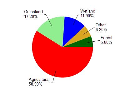
Irish Creek is located in the East Branch Rock River watershed which is 198.99 mi². Land use in the watershed is primarily agricultural (58.90%), grassland (17.20%) and a mix of wetland (11.90%) and other uses (12.00%). This watershed has 306.48 stream miles, 292.02 lake acres and 16,059.62 wetland acres.
Nonpoint Source Characteristics
This watershed is ranked High for runoff impacts on streams, High for runoff impacts on lakes and High for runoff impacts on groundwater and therefore has an overall rank of High. This value can be used in ranking the watershed or individual waterbodies for grant funding under state and county programs.However, all waters are affected by diffuse pollutant sources regardless of initial water quality. Applications for specific runoff projects under state or county grant programs may be pursued. For more information, go to surface water program grants.
Irish Creek is considered a Warm Mainstem, Coldwater under the state's Natural Community Determinations.
Natural communities (stream and lake natural communities) represent model results and DNR staff valiation processes that confirm or update predicted conditions based on flow and temperature modeling from historic and current landscape features and related variables. Predicated flow and temperatures for waters are associated predicated fish assemblages (communities). Biologists evaluate the model results against current survey data to determine if the modeled results are corect and whether biological indicators show water quaity degradation. This analysis is a core component of the state's resource management framework. Wisconsin's Riverine Natural Communities.
Warm Mainstem waters are moderate-to-large but still wadeable perennial streams with relatively warm summer temperatures. Coldwater fishes are absent, transitional fishes are common to uncommon, and warm water fishes are abundant to common. Headwater species are common to absent, mainstem species are abundant to common, and river species are common to absent.